Cumberland Township near Gettysburg in Adams County, Pennsylvania — The American Northeast (Mid-Atlantic)
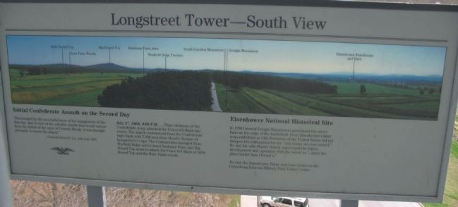
Longstreet Tower - South View
"Encouraged by the successful issue of the engagement of the first day, and in view of the valuable results that would ensure from the defeat of the army of General Meade, it was thought advisable to renew the attack."
-General Robert E. Lee, July 2nd, 1863
July 2nd, 1863, 4:00 P.M....Three divisions of the Confederate Army attacked the Union left flank and center. The attack commenced from the Confederate right flank with 7,300 men from Hood's division of Longstreet's Corps. The Confederates emerged from Warfield Ridge and crossed Bushman Farm and Big Round Top areas to attack the Union left flank at Little Round Top and the Rose Farm woods.
Eisenhower National Historic Site
In 1950 General Dwight Eisenhower purchased the above farm on the edge of the battlefield. Even Eisenhower's later responsibilities as 34th President of the United States did not dampen his enthusiasm for the "only home we ever owned." He and his wife Mamie closely supervised the farm's development and operation with the intent to "...leave the place better than I found it."
To visit the Eisenhower Farm, purchase tickets at the Gettysburg National Military Park Visitor Center.
Topics and series. This historical marker is listed in these topic lists: Agriculture • Settlements & Settlers • War, US Civil. In addition, it is included in the Former U.S. Presidents: #34 Dwight D. Eisenhower series list. A significant historical date for this entry is July 2, 1863.
Location. 39° 47.994′ N, 77° 15.356′ W. Marker is near Gettysburg, Pennsylvania, in Adams County. It is in Cumberland Township. Marker is at the intersection of West Confederate Avenue and Millerstown Road, on the left when traveling south on West Confederate Avenue. Located at the viewing level of the Longstreet Tower, near stop six of the driving tour of Gettysburg National Military Park. Touch for map. Marker is in this post office area: Gettysburg PA 17325, United States of America. Touch for directions.
Other nearby markers. At least 8 other markers are within walking distance of this marker. Longstreet Tower - East View (here, next to this marker); The Ashland Virginia Artillery (a few steps from this marker); Freedom Threatened (a few steps from this marker); Lieut. General James Longstreet (within shouting distance of this marker); McLaws's Division (within shouting distance of this marker); The Bedford Virginia Artillery (within shouting distance of this marker); Carlton's Battery - Cabell's Battalion (about 300 feet away, measured in a direct line); Parker's Battery - Alexander's Battalion (about 300 feet away). Touch for a list and map of all markers in Gettysburg.
More about this marker. Key points indicated in the panoramic view include Little Round Top, Rose Farm Woods, Big Round Top, Bushman Farm, Warfield Ridge, South Carolina Monument, Georgia Monument, and the Eisenhower Farm.
Related markers. Click here for a list of markers that are related to this marker. Gettysburg Markers and Monuments near the Longstreet Observation Tower.
Credits. This page was last revised on February 7, 2023. It was originally submitted on August 6, 2008, by Craig Swain of Leesburg, Virginia. This page has been viewed 1,857 times since then and 64 times this year. Photos: 1, 2, 3. submitted on August 6, 2008, by Craig Swain of Leesburg, Virginia.


