Rogersville in Lauderdale County, Alabama — The American South (East South Central)
Springfield Community 1810/Springfield Church and School
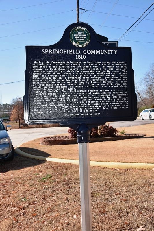
Springfield Community 1810
Springfield Community is believed to have been among the earliest settlements in Lauderdale County. It was laid out as a town and considered as the location for the county seat. As early as 1810, tenants on Doublehead Reserve were attracted to this area by numerous springs from which the community derived its name. The springs were located along a creek that ran southward and, at one time, had enough water flow to power a gristmill and gin. After 1825, George Butler, a physician from Georgia, purchased about 1100 acres of land in this area from the government and built the first house. Dr. Butler sold his land to Stephen Herman, a tenant plantation was acquired by Moses Crittenden who worked slaves under his overseer, Kit Stein.
Early in the Civil War, Confederate soldiers trained near one of the largest springs. There are reports of Union soldiers camping on the ridge to the east of this location and engaging in skirmishes with Confederate soldiers. The plantation was sold in 1901 to F. E. Jackson for one dollar an acre. The first roads in the area were trails. In 1919, Obadiah Brown was appointed overseer of a section of a road from Lamb's Ferry through Springfield into Tennessee. In 1933, Captain John West supervised the construction of a road from the mouth of Blue Water Creek to Springfield. John White was in charge of this road from here to Lexington.
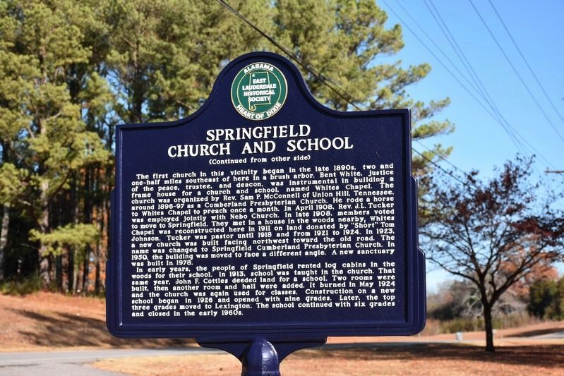
Springfield Church and School
The first church in this vicinity began inn the late 1890s, two and on-half miles southeast of here in a brush arbor. Bent White, justice of the peace, trustee, and deacon, was instrumental in building a frame house for a church and school, named Whites Chapel. The church was organized by Rev. Sam Pl. McConnell of Union Hill, Tennessee, around 1896-97 as a Cumberland Presbyterian Church. He rode a horse to Whites Chapel to preach once a month. In April 1908, Rev. J.L. Tucker was employed jointly with Nebo Church. In late 1908, members voted to move to Springfield. They met in a house in the woods, nearby, White Chapel was reconstructed here in 1911 on land donated by "Short" Tom Johnson. Tucker was pastor until 1918 and from 1921 to 1924 In 1923, a new church was built facing northwest toward the old road. The name was changed to Springfield Cumberland Presbyterian Church. In 1950, the building was moved to face a different angle. A new sanctuary was built in 1978.
In early years, the people of Springfield rented log cabins in the woods for their school. In 1913, school was taught in the church. That same year, John F. Cottles deeded land for a school. Two rooms were built, then another room and hall were added. It burned in May 1924, and the church was again used for classes. Construction on a new school began in 1926 and opened with nine grades. Later the top three grades moved to Lexington. The school with six grades and closed in the early 1960s.
Erected by East Lauderdale Hisorical Society.
Topics. This historical marker is listed in these topic lists: Churches & Religion • Education • Roads & Vehicles • Settlements & Settlers • War, US Civil.
Location. 34° 53.292′ N, 87° 23.287′ W. Marker is in Rogersville, Alabama, in Lauderdale County. Marker is at the intersection of Alabama Route 101 and County Route 646, on the right when traveling north on State Route 101. Touch for map. Marker is at or near this postal address: 5400 Highway 101, Rogersville AL 35652, United States of America. Touch for directions.
Other nearby markers. At least 8 other markers are within 5 miles of this marker, measured as the crow flies. Gabriel “Old Gabe” Butler (approx. 2 miles away); Elgin/Elgin Crossroads (approx. 2.6 miles away); Cherokee Chief Doublehead's Village Around 1800 (approx. 2.6 miles away); Daniel White (approx. 2.7 miles away); Covington/Second Creek / Wheeler Dam/Lake
(approx. 3.2 miles away); Jesse James Gang Canal Payroll Robbery/Trial of Frank James (approx. 3.3 miles away); Mitchell Town Community (approx. 3˝ miles away); Center (Centre) Star (approx. 4.2 miles away). Touch for a list and map of all markers in Rogersville.
Credits. This page was last revised on December 30, 2016. It was originally submitted on December 22, 2016, by Sandra Hughes Tidwell of Killen, Alabama, USA. This page has been viewed 736 times since then and 27 times this year. Photos: 1, 2, 3. submitted on December 22, 2016, by Sandra Hughes Tidwell of Killen, Alabama, USA. • Bernard Fisher was the editor who published this page.


