Apalachicola in Franklin County, Florida — The American South (South Atlantic)
When the River Was King!
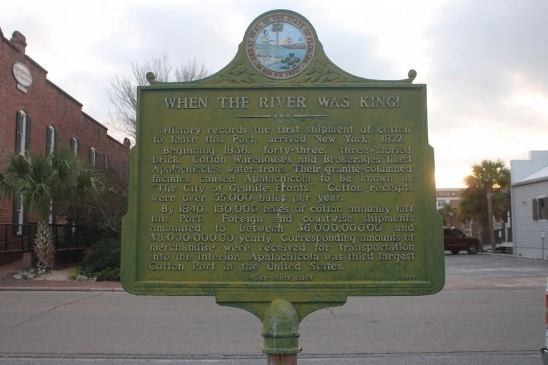
History records the first shipment of cotton to leave this Port, arrived New York, 1822. Beginning 1836, forty-three, three-storied brick, Cotton Warehouses and Brokerages lined Apalachicola's water front. Their granite-columned facades caused Apalachicola to be known as "The City of Granite Fronts." Cotton receipts were over 55,000 bales per year.
By 1840, 130,000 bales of cotton annually left this Port. Foreign and coastwise shipments amounted to between $6,000,000.00 and $8,000,000.00 yearly. Corresponding amounts of merchandise were received for transportation into the interior. Apalachicola was the third largest Cotton Port in the United States.
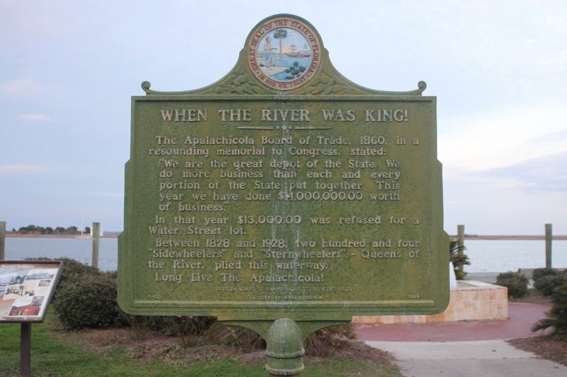
The Apalachicola Board of Trade, 1860, in a resounding memorial to Congress, stated:
"We are the great depot of the State. We do more business than each and every portion of the State put together. This year we have done $14,000,000.00 worth of business."
In that year $13,000.00 was refused for a Water Street lot.
Between 1828 and 1928 two hundred and four "Sidewheelers" and "Sternwheelers"- Queens of the River, plied this waterway.
Long Live The Apalachicola!
Erected 1964 by Florida Board of Parks and Historic Memorials In Cooperation With The City of Apalachicola. (Marker Number F-121.)
Topics. This historical marker is listed in these topic lists: Agriculture • Industry & Commerce • Settlements & Settlers • Waterways & Vessels. A significant historical year for this entry is 1822.
Location. 29° 43.707′ N, 84° 58.997′ W. Marker is in Apalachicola, Florida, in Franklin County. Marker is on Water Street, 0.1 miles north of Avenue D, on the right when traveling north. Marker is in Riverside Park. Touch for map. Marker is in this post office area: Apalachicola FL 32320, United States of America. Touch for directions.
Other nearby markers. At least 8 other markers are within walking distance of this marker. The Raney House (about 700 feet away, measured in a direct line); Fort Coombs - Franklin Guards (approx. 0.2 miles away); Franklin County (approx. 0.2 miles away); Methodist Episcopal Church South (approx. 0.2 miles away); The Hanserd-Fry House (approx. ¼ mile away); Dr. John Gorrie (approx. ¼ mile away); Trinity Episcopal Church (approx. ¼ mile away); The Dr. Alvan W. Chapman House (approx. 0.3 miles away). Touch for a list and map of all markers in Apalachicola.
Credits. This page was last revised on January 31, 2017. It was originally submitted on January 30, 2017, by Tim Fillmon of Webster, Florida. This page has been viewed 290 times since then and 25 times this year. Photos: 1, 2. submitted on January 30, 2017, by Tim Fillmon of Webster, Florida. 3. submitted on January 31, 2017, by Tim Fillmon of Webster, Florida. • Bernard Fisher was the editor who published this page.


