Near Columbia in Brown County, South Dakota — The American Midwest (Upper Plains)
Sand Lake National Wildlife Refuge
Welcome to
Photographed by Ruth VanSteenwyk, April 16, 2017
1. Sand Lake National Wildlife Refuge Marker
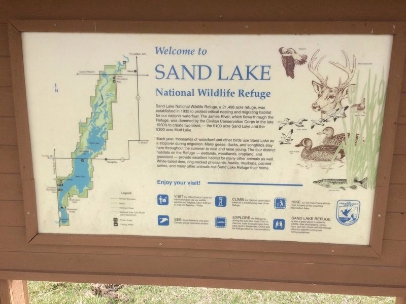
Sand Lake National Wildlife refuge, a 2,498 acre refuge, was established in 1935 to protect critical nesting and migrating habitat for our nation's waterfowl. The James River, which flows through the refuge, was dammed by the Civilian Conservation in the late 1930's to create two lakes - the 6100 acre Sand Lake and the 5300 acre Mud Lake.
Each year, thousands of waterfowl and other birds use Sand Lake as a stop over during migration. Many geese, ducks, and songbirds stay here throughout the summer to nest and raise young. The four distinct habitats on the Refuge - wetlands, woodlands, cropland and grassland - provide excellent habitat for many other animals as well. White-tailed deer, ring-necked pheasants, hawks, muskrats, painted turtles, and many other animals call Sand Lake Refuge their home.
Topics. This historical marker is listed in these topic lists: Animals • Environment • Waterways & Vessels. A significant historical year for this entry is 1935.
Location. 45° 43.577′ N, 98° 18.361′ W. Marker is near Columbia, South Dakota, in Brown County. It is on Sand Lake Dr. ¼ mile County Highway 16. Touch for map.
this page online

Regionally, this marker is in East River and specifically in the James River Valley. It is also in the American Midwest, in the Lewis & Clark Corridor, in the Corn Belt, on the prairies, and on the Northern Plains. Globally, it is in North America, the Western Hemisphere, the Western World, and the Anglosphere. Historically, it finds itself in what was once Rupert’s Land and also the Louisiana Purchase.
Other nearby markers. At least 8 other markers are within 5 miles of this marker, measured as the crow flies: Waterfowl (here, next to this marker); Songbirds (here, next to this marker); The View from the Top (approx. ¼ mile away); Sand Lake's Observation Tower (approx. ¼ mile away); Father Alexandra Ravoux (approx. 1.1 miles away); a different marker also named Sand Lake National Wildlife Refuge (approx. 3½ miles away); Civilian Conservation Corps Camp (approx. 3½ miles away); Columbia Marsh (approx. 4.7 miles away). Touch for a list and map of all markers in Columbia.
Photographed by Ruth VanSteenwyk, April 16, 2017
2. Sand Lake National Wildlife Refuge Marker
Photographed by Ruth VanSteenwyk, April 16, 2017
3. Sand Lake National Wildlife Refuge Sign
Credits. This page was last revised on April 21, 2017. It was originally submitted on April 19, 2017, by Ruth VanSteenwyk of Aberdeen, South Dakota. This page has been viewed 560 times since then and 33 times this year. Photos: 1, 2, 3. submitted on April 19, 2017, by Ruth VanSteenwyk of Aberdeen, South Dakota. • Bill Pfingsten was the editor who published this page.
