Santiago de Querétaro in Querétaro, Mexico — The Central Highlands (North America)
History of Querétaro
Photographed by J. Makali Bruton
1. History of Querétaro Marker
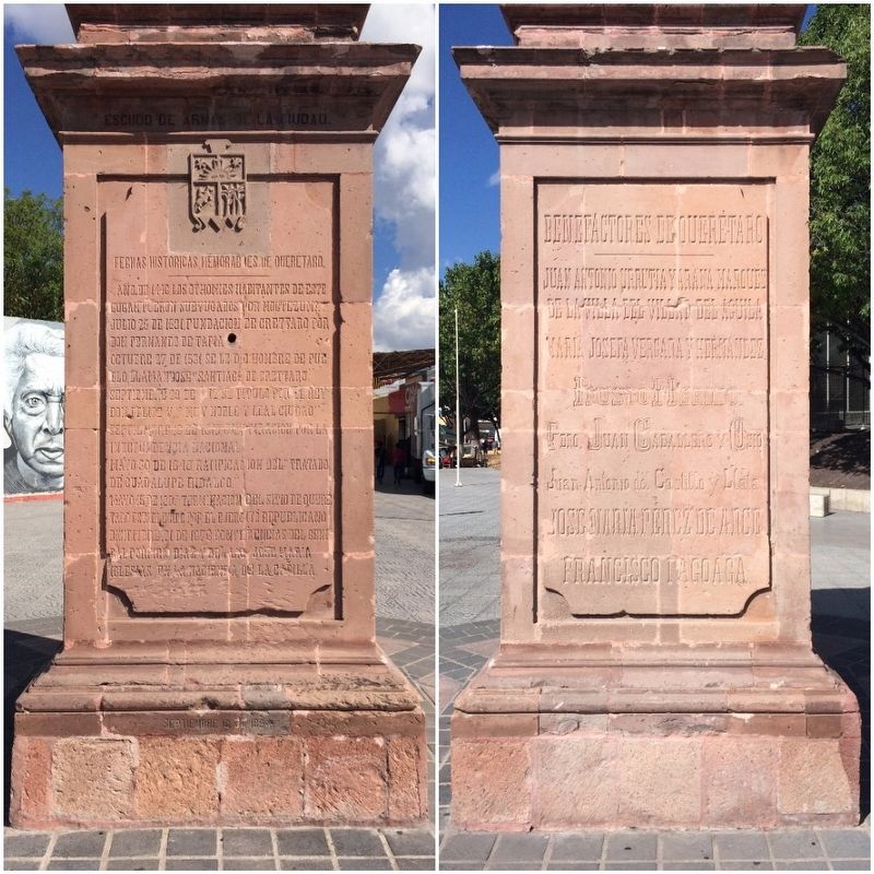
The north and west faces of the four-sided monument.
Julio 25 de 1531, fundación de Crettaro por Don Fernando de Tapia
Octubre 27 de 1531, se le dio nombre de pueblo, llamándose “Santiago de Crettaro.”
Septiembre 29 de 1712, se titulo por el Rey Don Felipe V, “Muy Noble y Leal Ciudad.”
Septiembre 13 de 1810, Conspiracion por la Independencia Nacional.
Mayo 30 de 1848, Ratificacion del “Tratado de Guadalupe Hidalgo.”
Mayo 15 de 1867, Terminacion del sitio de Queretaro establecido por el Ejercito Republicano.
Diciembre 21 de 1876, Conferencias del General Porfirio Diaz y del Lic. Jose Maria Iglesias en la Hacienda de la Capilla
Juan Antonio Urrutia y Arana Marques de la Villa del Villar del Aguila
Maria Josefa Vergara y Hernandez
Fausto Merino
Pbro. Juan Caballero y Osio
Juan Antonio del Castillo y Llala
Jose Maria Perez de Arce
Francisco Fagoaga
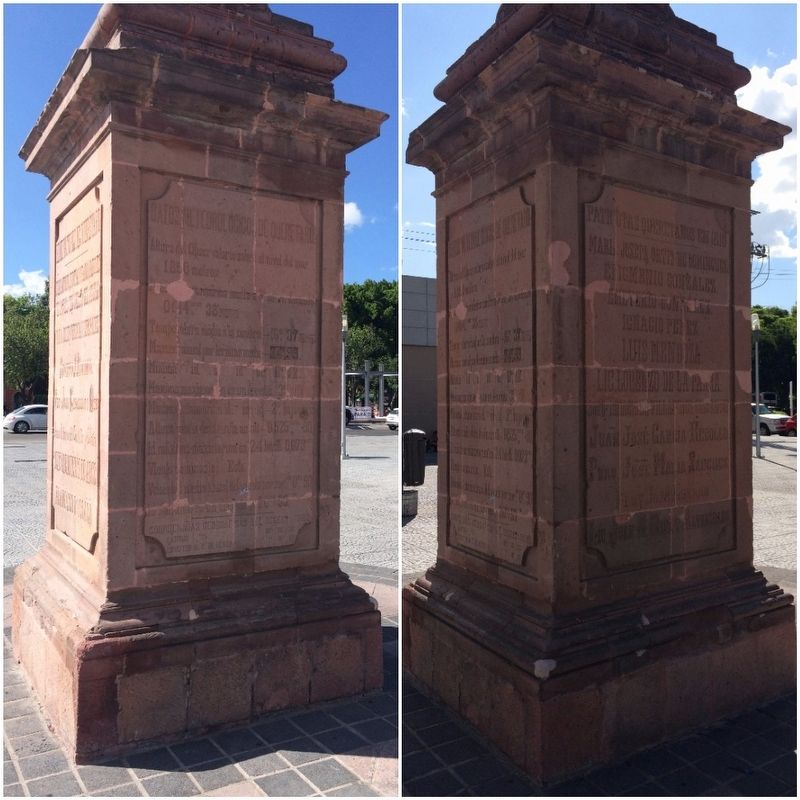
Datos Meteorologicos de Queretaro
Altura del Observatorio sobre el nivel del mar
1,850 metros
Illegible hidrica media a o en un decenio
0614.mm
this page online
Temperatura media a la sombra – 16o, 37
Maxima anual por termino medio – 24,o 99.
Minima/ id. id. id. id. 11o, 12.
Maxima maximorum en un decenio 35o, 10.
Minima minimorum id. id. id. – 2o, bajo cero
Altura media de la lluvia anual – 0525.mm 90
Id. máxima maximorum en 24 horas 0,073mm
Viento dominante, Este.
Velocidad media anual del viento por segde de 0.m 90
Id. maxima en un decenio 20.m 93.
Coordenadas geográficas del Observatorio.
Latitud 20o 35” 33’
Longitud al D. de Mexico 1o 1” 27’
Maria Josefa Ortiz de Dominguez
Epigmenio Gonzalez
Emeterio Gonzalez
Ignacio Perez
Luis Mendoza
Lic. Lorenzo de la Parra.
Jose Ignacio de Villaseñor Cervantes
Juan Jose Garcia Rebollo
Pbro. Jose Maria Sanchez
Fray Jose Lozano
Lic. Juan N. Mier y Altamirano
English translation:
July 25, 1531 - Foundation of “Crettaro” by Fernando de Tapia
October 27, 1531 – Named as a town, calling itself "Santiago de Crettaro"
September 29, 1712 – Given the
Photographed by J. Makali Bruton
2. History of Querétaro Marker
The south and east faces of the four-sided monument.
September 13, 1810 - Conspiracy of National Independence
May 30, 1848 - Ratification of the "Treaty of Guadalupe Hidalgo"
May 15, 1867 – End of the siege of Querétaro by the Republican Army
December 21, 1876 - Conferences of General Porfirio Díaz and José María Iglesias in the “Hacienda de la Capilla”
Juan Antonio Urrutia y Arana Marques de la Villa del Villar del Aguila
María Josefa Vergara y Hernández
Fausto Merino
Juan Caballero y Osio
Juan Antonio del Castillo and Llala
José María Pérez de Arce
Francisco Fagoaga
Querétaro Weather Data
Altitude of the Observatory from Sea Level
1850 meters
Illegible average in a decade
0614.mm 38
Average temperature in the shade - 16o, 37
Average annual - 24,o 99.
Minimum id. Id. Id. Id. 11o, 12.
Maximum in a decade 35o, 10.
Minima minimorum id. Id. Id. - 2or, below zero
Average annual rain - 0525.mm 90
Maximum maximorum id. in 24 hours 0.073mm
Dominant winds from the East.
Average annual wind speed per sec. 0.m 90
Maximum id. in a decade 20.m 93.
Geographical coordinates of the Observatory.
Latitude
Photographed by J. Makali Bruton, June 14, 2017
3. History of Querétaro Marker
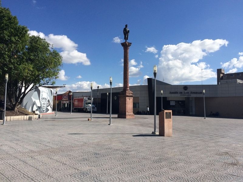
The marker and monument can be seen in the center in this view. To the right is the marker "Christopher Columbus Plaza".
Longitude D. of Mexico 1o 1" 27 '
María Josefa Ortíz de Domínguez
Epigmenio Gonzalez
Emeterio Gonzalez
Ignacio Pérez
Luis Mendoza
Lorenzo de la Parra
José Ignacio de Villaseñor Cervantes
Juan José Garcia Rebollo
José María Sánchez
José Lozano
Juan N. Mier y Altamirano
Erected 1894.
Topics. This historical marker is listed in these topic lists: Exploration • Man-Made Features • Patriots & Patriotism • Wars, Non-US. A significant historical year for this entry is 1446.
Location. 20° 35.165′ N, 100° 23.236′ W. Marker is in Santiago de Querétaro, Querétaro. It is on Avenida Constituyentes just east of Calle Corregidora, on the right when traveling east. Touch for map. Marker is in this post office area: Santiago de Querétaro QUE 76000, Mexico. Touch for directions.

Regionally, this marker is in Central Mexico and in the Bajío. Globally, it is in North America, specifically in Mesoamerica, on the Ring of Fire, and in the Western Hemisphere. Historically, it finds itself in what was once New Spain, a Spanish colony, and the Aztec Empire.
Other nearby markers. At least 8 other
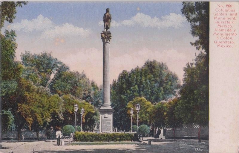
4. A postcard of the monument to Columbus in its previous location
The monument was previously in the nearby Alameda park and was probably replaced by the current statue of Miguel Hidalgo.
No. 266 Columbus Garden and Monument, Querétaro, Mexico, Alameda y Monumento a Colón, Querétaro, México.
No. 266 Columbus Garden and Monument, Querétaro, Mexico, Alameda y Monumento a Colón, Querétaro, México.
Credits. This page was last revised on November 30, 2018. It was originally submitted on July 8, 2017, by J. Makali Bruton of Washington, District of Columbia. This page has been viewed 636 times since then and 20 times this year. Photos: 1, 2, 3. submitted on July 8, 2017, by J. Makali Bruton of Washington, District of Columbia. 4. submitted on December 16, 2017, by J. Makali Bruton of Washington, District of Columbia.
