
The Tusket Islands
The Tusket Islands
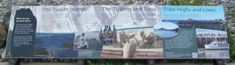
Located south of Yarmouth, the Tusket Islands extend mainly along the coast, from Pinkney's Point to Wedgeport. The Tusket Island chain was once a great asset to the fishing economy of Nova Scotia's Southwestern shore.
Duirng [sic - During] the late nineteenth century, fishermen and their families built thriving communities on the various islands, where they lived year-round, fished and operated businesses including stores, shops, and lobster canneries, well into the twentieth century. However, as it became increasingly difficult for inhabitants to weather the storms and harsh winters on the Tusket Islands, they eventually left for the mainland.
[Photo captions read]
• Aerial view showing part of the Tusket Island chain.
• Laurie Dane, wife of Fred Dane, fisherman, and their son, Gerald Dane at 15 months of age, May 1930, Ellenwood Island.
The Tuskets and Tuna
Throughout the 1930s and 1940s, sport fisherman [sic - fishermen] from all over the world came to the Tusket Islands and Wedgeport to fish the numerous Bluefin tuna that migrated through the island chain. By the 1950s, the seemingly endless
this page online
To find out more about tuna fishing in this region, visit the Wedgeport Sport Tuna Fishing Museum.
[Photo captions read]
• Annual Wedgeport Tuna Tournament
• Tuna sport fishing between Wedgeport and Green Island, c.1950s.
Tidal Highs and Lows
Located just below the Bay of Fundy, home of the World's highest tides, Yarmouth experiences its own amazing tidal highs and lows. There is a 4.5-metre (15-foot) rise and fall of tides daily - that means two high tides and two low tides in a 24-hour period.
To witness the powerful effect of the tides in our region, visit any of the various fishing ports and wharves throughout Yarmouth County. At low tides, you may see some of the fishing boats stranded in their inner harbours. When the next high tide fills the harbours, once again, the boats can leave to fish. In the summer and early
A Note to Visitors
For your safety, be sure to check the tidal schedule before planning any paddling or sailing activities in the region at: www.tides.gc.ca/eng/find/zone/31
[Photo captions read]
• [Photos showing] Low tide - High tide
• Fishing boat stranded at low tide, Port Maitland, Yarmouth County.
What can you see from here?
The strip of land, straight ahead, is Chebogue Point. On a clear day, the little sliver of land at its very tip is Owls Head Island, one of the famous Tusket Islands.
Just to your right, is another of the Tusket Islands, called Green Island, which you can also see on a clear day. It has a small lighthouse at its center.
Erected by Municipality of the District of Yarmouth.
Topics. This historical marker is listed in these topic lists: Environment • Industry & Commerce • Settlements & Settlers • Waterways & Vessels. A significant historical month for this entry is May 1930.
Location. 43° 47.492′ N, 66° 9.306′ W.

Regionally, this marker is in Nova Scotia’s Yarmouth and the Acadian Shores. It is also in the Maritimes and in Atlantic Canada. Globally, it is in the North Atlantic Region, North America, the Western Hemisphere, the Western World, and the Anglosphere. Historically, it finds itself in what was once a British colony, the Viceroyalty of New France, and Acadia.
Other nearby markers. At least 8 other markers are within walking distance of this marker: Harbour of Deception (within shouting distance of this marker); Cheboque (within shouting distance of this marker); A Footstep into the Harbour (about 90 meters away, measured in a direct line); Explosive Geology (about 150 meters away); Pieces of the Past (about 150 meters away); Welcome to the Leif Ericson Trail (approx. 0.2 kilometers away); A Diverse Fishery (approx. 0.3 kilometers away); Cape Forchu's Guiding Light (approx. 0.3 kilometers away). Touch for a list and map of all markers in Cape Forchu.
Also see . . .
1. The Tusket Islands. Coastal Adventures Website entry (Submitted on August 29, 2017, by William Fischer, Jr. of Reynoldsburg, Ohio.)
2. Tusket Islands Map. Mapcarta Website entry (Submitted on August 29, 2017, by William Fischer, Jr. of Reynoldsburg, Ohio.)
3. Tide Times for Yarmouth, Nova Scotia. Time & Forecast Website entry (Submitted on August 29, 2017, by William Fischer, Jr. of Reynoldsburg, Ohio.)
4. Cape Forchu: A Light Like No Other. Cape Forchu Lighthouse website homepage (Submitted on August 29, 2017, by William Fischer, Jr. of Reynoldsburg, Ohio.)
Credits. This page was last revised on May 4, 2021. It was originally submitted on August 29, 2017, by William Fischer, Jr. of Reynoldsburg, Ohio. This page has been viewed 483 times since then and 30 times this year. Photos: 1, 2. submitted on August 29, 2017, by William Fischer, Jr. of Reynoldsburg, Ohio.
