Klamath Falls in Klamath County, Oregon — The American West (Northwest)
Upper Klamath Lake
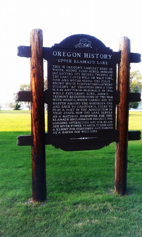
Photographed by Douglass Halvorsen, August 18, 2013
1. Upper Klamath Lake Marker
Erected by Oregon Travel Experience.
Topics and series. This historical marker is listed in these topic lists: Exploration • Indigenous Peoples and Communities • Waterways & Vessels. In addition, it is included in the Oregon Beaver Boards series list.
Location. 42° 14.044′ N, 121° 48.75′ W. Marker is in Klamath Falls, Oregon, in Klamath County. It is on Lakeshore Drive, on the right when traveling west. Touch for map. Marker is in this post office area: Klamath Falls OR 97601, United States of America. Touch for directions.

Regionally, this marker is in the High Desert and in Southern Oregon. It is also in the American Mountain West and in the Lewis & Clark Corridor. Globally, it is in North America, in the Cascade Range, on the Ring of Fire, on the Pacific Rim, in the Western Hemisphere, in the Western World, and in the Anglosphere.
Other nearby markers. At least 8 other markers are within 2 miles of this marker, measured as the crow flies: Oregon History - Upper Klamath Lake (here, next to this marker); The Legacy Link (approx. 0.4 miles away); Eulalona
this page online
Also see . . . Oregon Travel Experience - Upper Klamath Lake. (Submitted on January 11, 2018, by Douglass Halvorsen of Klamath Falls, Oregon.)
Credits. This page was last revised on January 15, 2018. It was originally submitted on January 11, 2018, by Douglass Halvorsen of Klamath Falls, Oregon. This page has been viewed 376 times since then and 39 times this year. Photo 1. submitted on January 11, 2018, by Douglass Halvorsen of Klamath Falls, Oregon. • Bill Pfingsten was the editor who published this page.
