Greer in Greenville County, South Carolina — The American South (South Atlantic)
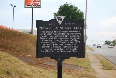
Indian Boundary Line
Erected 1952 by Joyce Scott Chapter, Daughters of the American Revolution. (Marker Number 23-4.)
Topics and series. This historical marker is listed in these topic lists: Colonial Era • Native Americans • Settlements & Settlers. In addition, it is included in the Daughters of the American Revolution series list. A significant historical year for this entry is 1777.
Location. 34° 56.882′ N, 82° 13.294′ W. Marker is in Greer, South Carolina, in Greenville County. Marker is on Wade Hampton Blvd. (U.S. 29) near Baileyview Street, on the right when traveling east. Marker is located on the Greenville/Spartanburg County line. Touch for map. Marker is in this post office area: Taylors SC 29687, United States of America. Touch for directions.
Other nearby markers. At least 10 other markers are within 2 miles of this marker, measured as the crow flies. A different marker also named Indian Boundary Line (approx. 0.6 miles away); 101 Trade Street (approx. 0.7 miles away); Tribute to Greer Firefighters (approx. ¾ mile away); National Highway (approx. ¾ mile away); Spring-Wood Park (approx. 0.8 miles away); Stone Mortar (approx. 0.8 miles away); AH-1 Cobra Helicopter (approx. 1.1 miles away); Worth Barnett Overpass (approx. 1.1 miles away); All Wars Memorial (approx. 1.1 miles away); Ronnie Eugene Norris Remembrance Fountain (approx. 1.1 miles away). Touch for a list and map of all markers in Greer.
Related markers. Click here for a list of markers that are related to this marker. Markes dedicated to the DeWitt Treaty and other Cherokee boundary lines.
Also see . . .
1. South Carolina Backcountry Election Districts of 1778 Map. During the Revolutionary War, in 1778, the new Whig Government of South Carolina passed legislation to establish new election districts. (Submitted on February 10, 2009, by Brian Scott of Anderson, South Carolina.)
2. Anglo-Cherokee War. The Anglo-Cherokee War (1758–1761) (Cherokee:"war with those in the red coats" or "war with the english"), also known (from the Anglo-European perspective) as the Cherokee War, the Cherokee Uprising, the Cherokee Rebellion, was a conflict between British forces in North America and Cherokee Indians during the French and Indian War. (Submitted on September 13, 2009, by Brian Scott of Anderson, South Carolina.)
Additional commentary.
1. The Treaty of DeWitt's Corner
Hostilities between the Cherokee Nation and the English settlers were ended with the signing of two treaties. The first, signed on May 20, 1777, was the treaty of DeWitt's Corner. Representatives from Georgia, South Carolina, and the Lower Cherokee met at DeWitt's Corner and signed a treaty that the territory now known as Anderson, Greenville, Oconee, and Pickens to South Carolina. The treaty forced the Cherokee to admit that South Carolina troops "did effect and maintain the conquest of all the Cherokee lands, eastward of Unacay Mountain." The treaty opened the region to an influx of Scotch-Irish Presbyterians and French Huguenot. The DeWitt Treaty was the first treaty between two American states (Georgia and South Carolina) and the Cherokee nation.
The second treaty was signed on July 20, 1777 at Long Island on the Holston River by headmen of Virginia, North Carolina, and the Upper Cherokee. Under the terms of this treaty, the Cherokee ceded all land east of the Blue Ridge to the settlers. With the signing of the second treaty, South Carolina took on its familiar triangle shape that is known today.
DeWitt's Corner was located on Corner Creek, at the present-day Abbeville/Anderson County line. To reach the creek, travel north on Highway 20 from Due West. The bridge crossing the creek is located about 1/5 of a mile from the county line.
— Submitted September 13, 2009, by Brian Scott of Anderson, South Carolina.
Credits. This page was last revised on January 25, 2021. It was originally submitted on June 20, 2008, by Brian Scott of Anderson, South Carolina. This page has been viewed 2,605 times since then and 71 times this year. Last updated on September 8, 2008, by Mike Stroud of Bluffton, South Carolina. Photo 1. submitted on June 20, 2008, by Brian Scott of Anderson, South Carolina. • Craig Swain was the editor who published this page.
