
Memphis in Shelby County, Tennessee — The American South (East South Central)
Cairo, Illinois
Mississippi River Walk
| — | Mile 954.0 AHP | — |

Photographed by Jason Voigt, August 2, 2024
1. Cairo, Illinois Marker
Marker was replaced with one put up by Mud Island Park
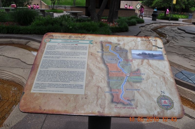
Cairo's position at the confluence of the Upper Mississippi and Ohio made it an important river and rail junction in the steamboat era. Changes in America's shipping patterns reduced its role in the 20th Century but it remains an active port and industrial area.
This area’s importance was recognized by the French explorer LaSalle in the late 17th Century. He foresaw Illinois’ future as the link between the Mississippi River and the Great Lakes-St. Lawrence system, but flooded lowlands long discouraged settlers.
Named for the venerable Egyptian City on the Nile, the first settlement failed in 1818.
Another attempt at town-building was more successful in 1837. Levees were built to keep the land dry, but the British company backing the project went bankrupt after three years. A group of eastern investors involved in the Illinois Central Railroad bought the town in 1846, and its luck changed. The 705-mile rail line between Cairo and Chicago was the world's longest when it opened in 1855, and the town prospered as the rail and river link for north-south trade.
The Civil War was a period of growth and prosperity
this page online
Today, Cairo is a shipping center for Southern Illinois and bridges over both rivers connect the town with Kentucky and Missouri. Lumber, woodworking and agricultural processing have become major industries.
Photo of confluence of Upper Mississippi and Ohio Rivers
Erected by Mississippi Riverwalk. (Marker Number 65.)
Topics. This historical marker is listed in these topic lists: Exploration • Settlements & Settlers • War, US Civil • Waterways & Vessels. A significant historical year for this entry is 1818.
Location. 35° 8.996′ N, 90° 3.504′ W. Marker is in Memphis, Tennessee, in Shelby County. It can be reached from
Photographed by Sandra Hughes, May 18, 2010
2. Cairo, Illinois Panel # 65 Marker

Regionally, this marker is in West Tennessee. It is also in the American South, specifically in the Deep South, in the Upper South, in the Mississippi Delta, and in the Great River Road Region. Globally, it is in North America, the Western Hemisphere, the Western World, and the Anglosphere. Historically, it finds itself in what was once the territory of the Mississippian Culture, one of the Confederate States of America, and the Antebellum South.
Other nearby markers. At least 8 other markers are within walking distance of this marker: Islands No. 2, 3, and 4 / Fort Jefferson, Kentucky / Bird’s Point, Missouri (a few steps from this marker); Island No. 5 (Wolf Island)/Belmont, Missouri/Columbus, Kentucky (a few steps from this marker); Donaldson Point, Missouri/Island No. 8/Hickman, Kentucky/Dorena Crevasse (a few steps from this marker); New Madrid, Missouri/Cates Casting Field/Island No. 10 (within shouting distance

Photographed by Sandra Hughes, August 12, 2012
3. Crossing the Ohio River at Cairo, Illinois
Also see . . . The sad story of Cairo, Illinois' abandoned downtown. If you head to their historic downtown district, you'll find a veritable ghost town-- abandoned storefronts, boarded up buildings, rusted street signs, and a lack of any sign of human life marks the once-busy street. (Submitted on March 8, 2018, by Sandra Hughes Tidwell of Killen, Alabama, USA.)

Photographed by Jason Voigt, August 2, 2024
4. Cairo, Illinois Marker
Credits. This page was last revised on August 30, 2024. It was originally submitted on March 8, 2018, by Sandra Hughes Tidwell of Killen, Alabama, USA. This page has been viewed 837 times since then and 38 times this year. Photos: 1. submitted on August 30, 2024, by Jason Voigt of Glen Carbon, Illinois. 2, 3. submitted on March 8, 2018, by Sandra Hughes Tidwell of Killen, Alabama, USA. 4. submitted on August 30, 2024, by Jason Voigt of Glen Carbon, Illinois. • Bernard Fisher was the editor who published this page.
