Crumpton in Queen Anne's County, Maryland — The American Northeast (Mid-Atlantic)
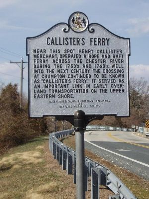
Callisterís Ferry
Erected by Queen Anneís County Bicentennial Commission and Maryland Historical Society.
Topics. This historical marker is listed in these topic lists: Colonial Era • Waterways & Vessels.
Location. 39° 14.622′ N, 75° 55.464′ W. Marker is in Crumpton, Maryland, in Queen Anne's County. Marker is on Crumpton Road (Maryland Route 290), on the left when traveling north. Touch for map. Marker is in this post office area: Crumpton MD 21628, United States of America. Touch for directions.
Other nearby markers. At least 8 other markers are within 6 miles of this marker, measured as the crow flies. Henry Highland Garnet (approx. 1.3 miles away); Veterans Memorial (approx. 4Ĺ miles away); Dudley's Chapel (approx. 4.6 miles away); a different marker also named Dudley's Chapel (approx. 4.6 miles away); Sudlersville Memorial Library (approx. 5.3 miles away); Sudlersville (approx. 5.3 miles away); James Emory Foxx (approx. 5.3 miles away); Sudlersville Train Station (approx. 5.3 miles away).
Credits. This page was last revised on March 13, 2018. It was originally submitted on October 16, 2007, by Kevin W. of Stafford, Virginia. This page has been viewed 1,556 times since then and 31 times this year. Last updated on March 11, 2018, by Devry Becker Jones of Washington, District of Columbia. Photos: 1. submitted on October 16, 2007, by Kevin W. of Stafford, Virginia. 2. submitted on October 27, 2007, by Bill Pfingsten of Bel Air, Maryland. • Bill Pfingsten was the editor who published this page.

