Memphis in Shelby County, Tennessee — The American South (East South Central)
Kenner, Louisiana/Davis Crevasse/Ormand Landing, Louisiana
Panel #9 Mississippi Riverwalk
Inscription.
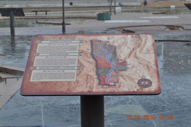
A) Kenner, Louisiana
Mile 113.0 AHP
This community grew up on a sugar plantation owned by the Kenner family and became a railroad stop in the antebellum years. During the U.S. Civil War, Union troops were sent to Kenner to destroy the rail line in 1892. Charges of pillaging and plundering by the Union soldiers were all confirmed by a military investigation, and the commanding general of New Orleans vowed to punish the offenders. In 1862, the second year of the war, the idea of “Civilized warfare” was still held by both sides.
B) Davis Crevasse
Mile 119.0 AHP
Rice was an early Louisiana export corp, and some of the first rice plantations were located in this area. Planters sometimes dug flumes in the levees to divert water into their rice fields, a dangerous practice which could weaken levees. Strict laws clamped down on rice flumes during the 1800’s and many were filled in. On March 8, 1884, a poorly closed rice flume on the Davis Plantation, gave way. The river opened a 1,000-foot wide crevasse in the level and water poured over the countryside for two weeks.
C) Ormand Landing, Louisiana
Mile 122.7 AHP
The Ormand Plantation house is one of the oldest still standing in Louisiana. Its cypress frame is filled with “bouzillage," a mixture of mud, Spanish moss a brick that hardens into a stone-like substance. This style of construction indicates that the house was built before 1790. German settlers built a small red-painted church just below the Ormand Plantation in 1806. River pilots used “Red Church“ as a navigation landmark unit it was torn down in 1930.
Erected by Mississippi Riverwalk. (Marker Number 9.)
Topics. This historical marker is listed in these topic lists: Disasters • Settlements & Settlers • War, US Civil • Waterways & Vessels. A significant historical date for this entry is March 8, 1884.
Location. 35° 8.968′ N, 90° 3.507′ W. Marker is in Memphis, Tennessee, in Shelby County. Marker can be reached from Island Drive, 0.8 miles south of West A.W. Willis Avenue when traveling south. Located in Mud Island River Park. Touch for map. Marker is at or near this postal address: 125 N Front St, Memphis TN 38103, United States of America. Touch for directions.
Other nearby markers. At least 8 other markers are within walking distance of this marker. The Mississippi Riverwalk (here, next to this marker); Ohio River (here, next to this marker); Cairo, Illinois (here, next to this marker); Islands No. 2, 3, and 4 / Fort Jefferson, Kentucky / Bird’s Point, Missouri (here, next to this marker); Island No. 5 (Wolf Island)/Belmont, Missouri/Columbus, Kentucky (here, next to this marker); Donaldson Point, Missouri/Island No. 8/Hickman, Kentucky/Dorena Crevasse (here, next to this marker); New Madrid, Missouri/Cates Casting Field/Island No. 10 (here, next to this marker); Tiptonville, Tennessee/Bixby Towhead (here, next to this marker). Touch for a list and map of all markers in Memphis.
Also see . . .
1. Kenner, Louisiana. Kenner (historically French: Cannes-Brûlées)[4] is the sixth-largest city in the U.S. State of Louisiana. It is the largest city in Jefferson Parish, United States and a suburb of New Orleans. The population was 66,702 at the 2010 census. (Submitted on March 12, 2018, by Sandra Hughes Tidwell of Killen, Alabama, USA.)
2. Ormand Plantation. Ormond Plantation has survived into the early 21st Century with its unique character and sometimes tragic history. In the early 1780's, Pierre D'Trepagnier was awarded a tract of land by the Spanish Governor Don Bernanrdo deGalvez. The Main building was completed shortly before 1790, the plantation home to indigo and then to sugar cane. (Submitted on March 12, 2018, by Sandra Hughes Tidwell of Killen, Alabama, USA.)
Credits. This page was last revised on March 13, 2018. It was originally submitted on March 12, 2018, by Sandra Hughes Tidwell of Killen, Alabama, USA. This page has been viewed 174 times since then and 11 times this year. Photo 1. submitted on March 12, 2018, by Sandra Hughes Tidwell of Killen, Alabama, USA. • Bernard Fisher was the editor who published this page.
Editor’s want-list for this marker. Wide shot of marker and its surroundings. • Can you help?
