Memphis in Shelby County, Tennessee — The American South (East South Central)
Hog Point, Louisiana/Raccourci Cutoff/Caernarvon Crevasse
Mississippi River Walk
Photographed by Jason Voigt, August 2, 2024
1. Hog Point, Louisiana/Raccourci Cutoff/Caernarvon Crevasse Marker
Marker was replaced by one put up by Mud Island Park.
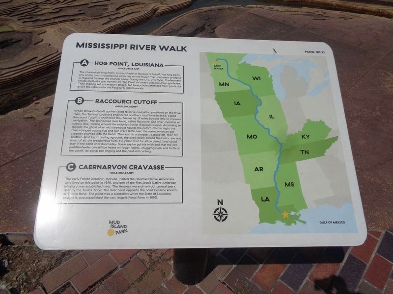
A) Hog Point, Louisiana
Mile 298.2 AHP
The channel off Hog Point, in the middle of Raccourci Cutoff, has long been one of the most troublesome stretches on the lower river. Constant dredging is required to keep the channel open. During the U.S. Civil War, Confederate forces erected a gun battery on Hog Point to harass passing Union gunboats. Their shelling set a transport ablaze, but heavy bombardment from gunboats drove the rebels into the Raccourci Island woods.
B) Raccourci Cutoff
Mile 288.4 AHP
When Shreve’s Cutoff upriver failed to solve navigation problems on the lower river, the State of Louisiana engineered another cutoff here in 1848. Called Raccourci Cutoff, it shortened the channel by 19 miles but did little to improve navigation. The abandoned river bend, called Raccourci Old River, became an oxbow lake, curling around the roughly circular Raccourci Island. According to legend, the ghost of an old steamboat haunts the cutoff. On the night the river changed course fog and rain were thick over the water when an old steamer churned into the bend. The boat hit a sandbar, backed off, then hit another.
this page online
C) Caernarvon Crevasse
Mile 302.8 AHP
The early French explorer, Iberville, visited the Houmas Indians who lived on this point in 1699, and one of the first Jesuit Indian Mission was established here. The Houmas Indians were driven out several years later by the Tunic Tribe. The river bend opposite the point became known as Tunica Bend. The point was a plantation when the State of Louisiana bought it, established the vast Penal Farm in 1890.
Erected by Mississippi River Walk. (Marker Number 21.)
Topics. This historical marker is listed in these topic lists: Indigenous Peoples and Communities • War, US Civil • Waterways & Vessels.
Location. 35° 8.813′ N, 90° 3.579′ W. Marker is in Memphis, Tennessee,

Photographed by Sandra Hughes, May 18, 2010
2. Hog Point, Louisiana/Raccourci Cutoff/Caernarvon Crevasse Marker

Regionally, this marker is in West Tennessee. It is also in the American South, specifically in the Deep South, in the Upper South, in the Mississippi Delta, and in the Great River Road Region. Globally, it is in North America, the Western Hemisphere, the Western World, and the Anglosphere. Historically, it finds itself in what was once the territory of the Mississippian Culture, one of the Confederate States of America, and the Antebellum South.
Other nearby markers. At least 8 other markers are within walking distance of this marker: The Atchafalaya Problem (a few steps from this marker); Fort Adams, Mississippi/Old River Control Structure/Homochitto Cutoff (a few steps from this marker); St. Maurice, Louisiana/Morganza Floodway (a few steps from this marker); Port Hudson, Louisiana/Fausse River Cutoff (a few steps from this marker); Palmetto Bend/Jackson Point/St. Catherine’s Creek/Ellis Cliffs (a
Photographed by Jason Voigt, August 2, 2024
3. Hog Point, Louisiana/Raccourci Cutoff/Caernarvon Crevasse Marker
Marker is on the left
Also see . . . The First French Settlements, 1699–1713. 64 Parishes website entry:
French Crown officials paid little attention to the needs of Lower Louisiana during the early 1700s because of their involvement in the War of Spanish Succession (1701–1714). Lacking official support, Iberville and his elite associates were unable to implement the conventional French mercantilist practice of exploiting natural resources (furs, minerals, cash crops) from colonial territories. To compensate for supply shortages, French colonists relied heavily on the slave labor and agricultural acumen of neighboring Native American groups. To protect against the slave raids and military advances of British-allied tribes such as the Creek, Native American villages in the vicinity of Mobile developed close working relationships with the French. The Choctaw and Chickasaw were especially influential in how the French developed strategies to defend against British encroachment throughout frontier areas east of the Mississippi River. The close interconnectedness of Native Americans and Europeans during this early colonization phase convinced historian Daniel Usner to describe French colonial Louisiana as a “frontier exchange economy” influenced by local and regional networks as well as transatlantic and global movements. (Submitted on March 14, 2018, by Sandra Hughes Tidwell of Killen, Alabama, USA.)
Credits. This page was last revised on September 10, 2024. It was originally submitted on March 14, 2018, by Sandra Hughes Tidwell of Killen, Alabama, USA. This page has been viewed 1,089 times since then and 100 times this year. Photos: 1. submitted on September 10, 2024, by Jason Voigt of Glen Carbon, Illinois. 2. submitted on March 14, 2018, by Sandra Hughes Tidwell of Killen, Alabama, USA. 3. submitted on September 10, 2024, by Jason Voigt of Glen Carbon, Illinois. • Bernard Fisher was the editor who published this page.
