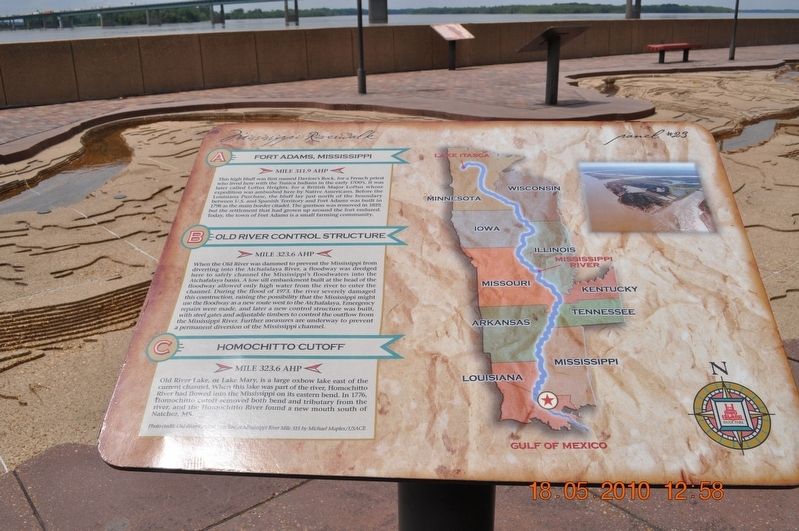
Fort Adams, Mississippi/Old River Control Structure/Homochitto Cutoff
Panel # 23
A. Fort Adams, Mississippi
Mile 311.9 AHP
This high bluff was first named Davionís Rock, for a French priest who lived here with the Tunica Indians in the early 1700ís. It was later called Loftus Heights, for a British Major Loftus whose expedition was ambushed here by Native Americans. Before the Louisiana Purchase, the bluff lay just north of the boundary between U. S. And Spanish Territory and Fort Adams was built in 1798 as the main border citadel. The garrison was removed in 1819, but the settlement that had grown up around the fort endured. Today, the town of Fort Adams is a small farming community.
B. Old River Control Structure
Mile 323.6 AHP
When the Old River was dammed to prevent the Mississippi from diverting into the Atchafalaya River, a floodway was dredged here to safely channel the Mississippiís floodwaters into the Atchafalaya basin. A low till embankment built at the head of the floodway allowed only high water for the river to enter the channel. During the flood of 1973, the river severely damaged this construction raising the possibility that the Mississippi might use the floodway as a new route west to the Atchafalaya. Emergency repairs were made and later a new control structure was built, with steel gates and adjustable timbers to control the outflow from the Mississippi
River. Further measures are underway to prevent permanent diversion of the Mississippi channel.
C. Homochitto Cutoff
Mile 323.6 AHP
Old River Lake, or Lake Mary, is a large oxbow lake east of the current channel. When this lake was part of the river, Homochitto River flowed into the Mississippi on its eastern bend. In 1776, Homochitto cutoff removed both bend and tributary from the river and the Homochitto River found a new mouth south of Natchez, MS.
Photo credit: Old River structure at Mississippi River Mile 315 by Michael Maples/USACE (Marker Number 23.)
Topics. This historical marker is listed in these topic lists: Native Americans • Waterways & Vessels. A significant historical year for this entry is 1776.
Location. 35° 8.851′ N, 90° 3.328′ W. Marker is in Memphis, Tennessee, in Shelby County. It is in Downtown Memphis. Marker is on Riverside Drive. Mud Island Mississippi Riverwalk. Touch for map. Marker is at or near this postal address: 125 N Front St, Memphis TN 38103, United States of America. Touch for directions.
Other nearby markers. At least 8 other markers are within walking distance of this marker. Mud Island (a few steps from this marker); Mississippi River Park (within shouting distance of this marker); The Sultana Disaster (within shouting distance of this marker); Cobblestone Landing (within shouting distance of this marker); Confederate Park
Also see . . .
1. Fort Adams, Mississippi. Fort Adams is a small, river port community in Wilkinson County, Mississippi, United States,[1] about 40 miles south of Natchez. It is notable for having been the U.S. port of entry on the Mississippi River, before the acquisition of New Orleans; it was the site of an early fort by that name. The town was called Wilkinburg and was incorporated in 1798. Prior to that time, the community was known as Loftus Heights and formerly had been a Jesuit mission called the Rock of Davion, first settled as such circa 1689-1700. This is also the site where the Choctaw Treaty of Fort Adams was signed in 1801. (Submitted on March 14, 2018, by Sandra Hughes Tidwell of Killen, Alabama, USA.)
2. Homochitto River. In 1938 the United States Army Corps of Engineers began channelizing the river by building the Abernathy Channel, a cutoff running from the Homochitto River near Doloroso to the Mississippi River about 15 miles (24 km) upstream from where the Homochitto originally emptied into the Mississippi. This reduced the river's length below Doloroso from about 20 miles (32 km) of meandering distributaries to a 9 miles (14 km) relatively straight outlet. Additional cutoffs between Doloroso and Rosetta were constructed in 1940, reducing the river's channel by about 4 miles (6 km). (Submitted on March 14, 2018, by Sandra Hughes Tidwell of Killen, Alabama, USA.)
Credits. This page was last revised on February 7, 2023. It was originally submitted on March 14, 2018, by Sandra Hughes Tidwell of Killen, Alabama, USA. This page has been viewed 603 times since then and 52 times this year. Photo 1. submitted on March 14, 2018, by Sandra Hughes Tidwell of Killen, Alabama, USA. • Bill Pfingsten was the editor who published this page.
