Inner Harbor in Baltimore, Maryland — The American Northeast (Mid-Atlantic)
The Great Baltimore Oyster Partnership
Photographed by Devry Becker Jones (CC0), March 20, 2018
1. The Great Baltimore Oyster Partnership Marker
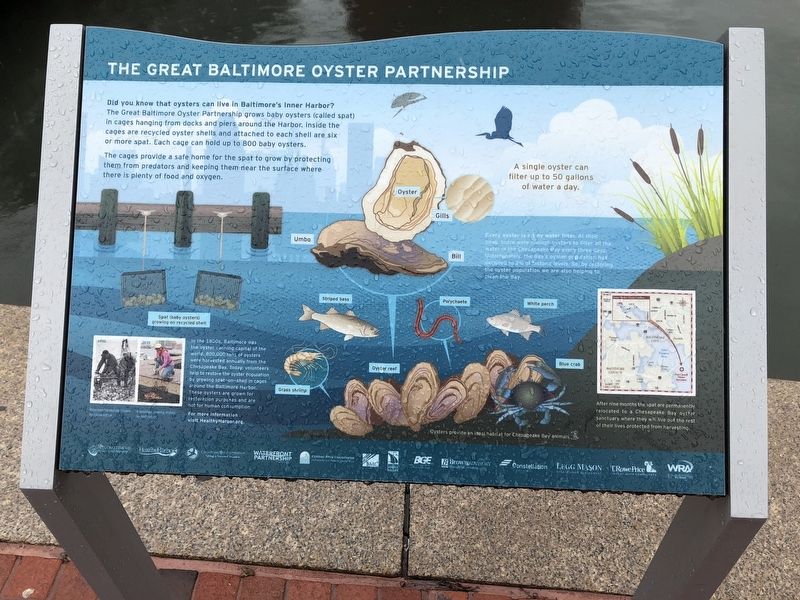
The Great Baltimore Oyster Partnership grows baby oysters (called spat) in cages hanging from docks and piers around the Harbor, inside the cages are recycled oyster shells and attached to each shell are six or more spat. Each cage can hold up to 800 baby oysters.
The cages provide a safe home fro the spat to grow by protecting them from predators and keeping them near the surface where there is plenty of food and oxygen.
Image captions:
1950 - Watermen harvesting oysters for consumption.
2015 - A volunteer growing oysters for restoration.
In the 1800s, Baltimore was the oyster canning capital of the world. 800,000 tons of oysters were harvested annually from the Chesapeake Bay. Today, volunteers help to restore the oyster population by growing spat-on-shell in cages around the Baltimore Harbor. These oysters are grown fro restoration purposes are not for human consumption.
For more information visit HealthyHarbor.org.
Every oyster is a tiny water filter. At their peak, there were
this page online
After nine months the spat are permanently relocated to a Chesapeake Bay oyster sanctuary where they will live out the rest of their lives protected from harvesting.
Oysters provide an ideal habitat for Chesapeake Bay animals.
Topics. This historical marker is listed in these topic lists: Animals • Environment • Industry & Commerce • Waterways & Vessels. A significant historical year for this entry is 1950.
Location. 39° 17.162′ N, 76° 36.532′ W. Marker is in Baltimore, Maryland. It is in the Inner Harbor. It is on East Pratt Street west of South Gay Street, on the right when traveling east. Touch for map. Marker is at or near this postal address: Pier 3, Baltimore MD 21202, United States of America. Touch for directions.

Regionally, this marker is in Central Maryland. It is also in the American Mid-Atlantic, in the Chesapeake Bay Region, and on the Eastern Seaboard. Globally,
Photographed by Devry Becker Jones (CC0), March 20, 2018
2. The Great Baltimore Oyster Partnership Marker
Other nearby markers. At least 8 other markers are within walking distance of this marker: Lightship Chesapeake (a few steps from this marker); Living Classrooms (a few steps from this marker); Piedmont Plateau (within shouting distance of this marker); Atlantic Coastal Plain (within shouting distance of this marker); Living with Wildlife (within shouting distance of this marker); Historic Ships in Baltimore (within shouting distance of this marker); "Yuai" (within shouting distance of this marker); a different marker also named Baltimore Riot Trail (within shouting distance of this marker). Touch for a list and map of all markers in Baltimore.
Another marker is no longer nearby. Baltimore Riot Trail (was within shouting distance of this marker but has been replaced with another marker now near it).
Credits. This page was last revised on April 17, 2020. It was originally submitted on March 20, 2018, by Devry Becker Jones of Washington, District of Columbia. This page has been viewed 448 times since then and 25 times this year. Photos: 1, 2. submitted on March 20, 2018, by Devry Becker Jones of Washington, District of Columbia. • Andrew Ruppenstein was the editor who published this page.
