
Memphis in Shelby County, Tennessee — The American South (East South Central)
Willow Cutoff/Salem Crevasse/Goodrich Landing,Louisiana
Mississippi River Walk

Photographed by Jason Voigt, August 2, 2024
1. Willow Cutoff/Salem Crevasse/Goodrich Landing,Louisiana Marker
Marker was replaced by one put up by Mud Island Park.
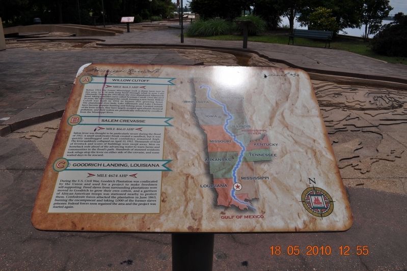
A) Willow Cutoff
Mile 464.3 AHP
Before 1913, the lower Mississippi took a sharp turn east in this area, in a 14-mile long bend through what is now Lake Albemarle. During the 1913 flood, the river abandoned Albermarle Bend, taking a smaller curve called Newman Cutoff. Over the next 20 years, the river enlarged the cutoff, forming a new bend. Willow Cutoff was built in 1934 to bypass this growing bend. The abandoned river beds, Lake Albemarle and Lake Chotard, have been popular hunting and fishing areas. Located outside of the levee system, they have largely avoided agricultural chemical pollution, and their waters are periodically refreshed by overflowing from the Mississippi River.
B) Salem Crevasse
Mile 466.0 AHP
Salem levee was thought to be particularly secure during the flood of 1912. A small underwater break created a sand boil, but it was quickly sandbagged and local confidence remained high. The levee suddenly collapsed on April 13, 1912. Thousands of head of livestock and scores of the building were swept away. Men on horseback rode ahead of the advancing water to warn farmers and communities in the flood’s
this page online
C) Goodrich Landing, Louisiana
Mile 467.4 AHP
During the U. S. Civil War, Goodrich Plantation was confiscated by the Union and used for a project to make freedmen self-supporting. Freed slaves from surrounding plantations were moved to Goodrich to grow their own cotton, and a garrison of African-American troops was stationed nearby to protect them. Confederate forces attacked the plantation in June 1863, burning the encampment and taking 1,000 of the former slaves prisoner. Federal forces soon regained the area and the project was started again.
Erected by Mississippi Riverwalk. (Marker Number 34.)
Topics. This historical marker is listed in these topic lists: Disasters • War, US Civil • Waterways & Vessels. A significant historical date for this entry is April 13, 1912.
Location. 35° 8.864′ N, 90° 3.561′ W. Marker is in Memphis, Tennessee, in Shelby County. It can be reached from Island Drive. Marker is located at Mud Island Park. Touch for map. Marker is at or near this postal address: 125 N
Photographed by Sandra Hughes, May 18, 2010
2. Willow Cutoff/Salem Crevasse/Goodrich Landing,Louisiana Marker

Regionally, this marker is in West Tennessee. It is also in the American South, specifically in the Deep South, in the Upper South, in the Mississippi Delta, and in the Great River Road Region. Globally, it is in North America, the Western Hemisphere, the Western World, and the Anglosphere. Historically, it finds itself in what was once the territory of the Mississippian Culture, one of the Confederate States of America, and the Antebellum South.
Other nearby markers. At least 8 other markers are within walking distance of this marker: Lake Providence, Louisiana/Stack Island (a few steps from this marker); Young’s Point / Milliken’s Bend / Omega Landing (a few steps from this marker); Yazoo River/Centennial Cutoff (a few steps from this marker); Vicksburg, Mississippi (a few steps from this marker); Skipwith Crevasse/Sara Cutoff/Island No. 89 (a few steps from this marker); Davis Island, Mississippi/Kents Island (a few steps from this marker); Grand Lake Cutoff/Worthington Cutoff/Kentucky Bend (within shouting distance of this marker); Grand Gulf, Mississippi / Yucatan Cutoff / Big Black River

Photographed by Jason Voigt, August 2, 2024
3. Willow Cutoff/Salem Crevasse/Goodrich Landing,Louisiana Marker
Also see . . . Battle of Goodrich's Landing. Goodrich's Landing was a cotton plantation owned by Henry Goodrich of East Carroll Parish, Louisiana. Situated on the west bank of the Mississippi River, the landing served as a shipping point for area cotton planters. When Union forces invaded the region in early 1862, they seized the plantation and established it as a base of operations in their advance against Vicksburg. As hundreds of escaped slaves flocked to the Union camp, neighboring plantation owners abandoned their properties and evacuated to the west, into Confederate held territory. (Submitted on March 27, 2018, by Sandra Hughes Tidwell of Killen, Alabama, USA.)
Credits. This page was last revised on September 13, 2024. It was originally submitted on March 27, 2018, by Sandra Hughes Tidwell of Killen, Alabama, USA. This page has been viewed 937 times since then and 62 times this year. Photos: 1. submitted on September 13, 2024, by Jason Voigt of Glen Carbon, Illinois. 2. submitted on March 27, 2018, by Sandra Hughes Tidwell of Killen, Alabama, USA. 3. submitted on September 13, 2024, by Jason Voigt of Glen Carbon, Illinois. • Bernard Fisher was the editor who published this page.
