Memphis in Shelby County, Tennessee — The American South (East South Central)
Ashbrook Cutoff/Eunice Landing, Arkansas/Arkansas City, Arkansas
Mississippi River Walk
Photographed by Jason Voigt, August 2, 2024
1. Ashbrook Cutoff/Eunice Landing, Arkansas/Arkansas City, Arkansas Marker
Marker was replaced with one put up by Mud Island Park
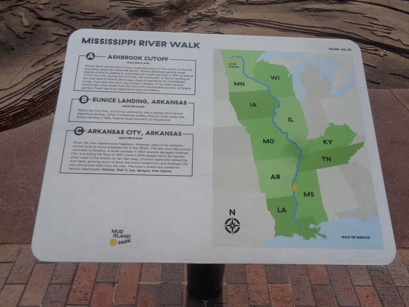
A) Ashbrook Cutoff
Mile 549.0 AHP
Rowdy Bend was the first of four consecutive loops, in this stretch of the river that pilots called the “Greenville Bends.” Rowdy Bend kept getting longer despite efforts to stabilize it, and Ashbrook Cutoff was built in 1935 to remove it from the river. During the Civil War, the community of Gaines Landing on the west bank of rowdy Bend was a bee of operations for Confederate troops. Even after the town was burned, a battery of ten rebel cannons bombarded Union boats from the ruins with considerable success. A Federal garrison finally had to be stationed to stop the shelling.
B) Eunice Landing, Arkansas
Mile 553.5 AHP
Before the Civil War, the Eunice community was a railroad terminal and steamboat landing. When Confederate artillery fired on Union boats near Eunice Landing in 1863, Federal troops burned it to the ground.
C) Arkansas City, Arkansas
Mile 558.0 AHP
When the river washed away Napoleon, Arkansas, many of its residents moved south to found Arkansas City in the 1870’s. The new town also proved vulnerable to flooding. A levee crevasse in 1903 serenely damaged Arkansas
this page online
Photo Credit: Greenville, Mississippi on April 27, 1927-by Steve Nicklas, NOS, NGS, Historic NWS Collection
Erected by Mississippi Riverwalk. (Marker Number 39.)
Topics. This historical marker is listed in these topic lists: Settlements & Settlers • War, US Civil • Waterways & Vessels.
Location. 35° 8.891′ N, 90° 3.568′ W. Marker is in Memphis, Tennessee, in Shelby County. It can be reached from Island Drive when traveling south. Located in Mud Island Park. Touch for map. Marker is at or near this postal address: 125 N Front St, Memphis TN 38103, United States of America. Touch for directions.

Regionally, this marker is in West Tennessee. It is also in the American South, specifically in the Deep South, in the

Photographed by Sandra Hughes, May 18, 2010
2. Ashbrook Cutoff/Eunice Landing, Arkansas/Arkansas City, Arkansas Marker
Other nearby markers. At least 8 other markers are within walking distance of this marker: Mounds Landing Crevasse/Cypress Bend/Caulk Neck Cutoff (a few steps from this marker); Gauges and Navigation Lights (a few steps from this marker); American Cutoff Mile/Greenville, Mississippi/Tarpley Cutoff (a few steps from this marker); Ozark Island No. 75 / Napoleon, Arkansas / Rosedale, Mississippi (a few steps from this marker); Grand Lake Cutoff/Worthington Cutoff/Kentucky Bend (a few steps from this marker); a different marker also named Arkansas & White Rivers (a few steps from this marker); Skipwith Crevasse/Sara Cutoff/Island No. 89 (within shouting distance of this marker); Victoria Bend/Montgomery Post, Arkansas/Arkansas Post/Concordia Bend (within shouting distance of this marker). Touch for a list and map
Photographed by Jason Voigt, August 2, 2024
3. Ashbrook Cutoff/Eunice Landing, Arkansas/Arkansas City, Arkansas Marker
Marker is on the left
Another marker is no longer nearby. Arkansas & White Rivers (was a few steps from this marker but has been replaced with another marker now near it).
Also see . . . Napoleon, Arkansas. Napoleon is a "drowned town" in Desha County, Arkansas, United States, near the confluence of the Arkansas and Mississippi rivers. Once the county seat, Napoleon was doomed when in 1863, a channel was cut through the soft land that inadvertently directed the river waters toward the town. It was finally submerged in 1874 when the banks of the Mississippi River burst through and destroyed the last of the once-thriving river port town.[1] (Submitted on March 27, 2018, by Sandra Hughes Tidwell of Killen, Alabama, USA.)
Credits. This page was last revised on August 24, 2024. It was originally submitted on March 27, 2018, by Sandra Hughes Tidwell of Killen, Alabama, USA. This page has been viewed 748 times since then and 62 times this year. Photos: 1. submitted on August 24, 2024, by Jason Voigt of Glen Carbon, Illinois. 2. submitted on March 27, 2018, by Sandra Hughes Tidwell of Killen, Alabama, USA. 3. submitted on August 24, 2024, by Jason Voigt of Glen Carbon, Illinois. • Bernard Fisher was the editor who published this page.
