Old Town in Alexandria, Virginia — The American South (Mid-Atlantic)
The Port City
City of Alexandria Est. 1749
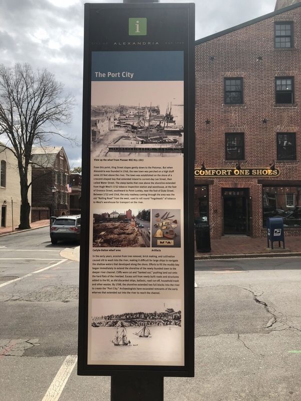
From this point, King Street slopes gently down to the Potomac. But when Alexandria was founded in 1749, the new town was perched on a high bluff some 20 feet above the river. The town was established on a shore of a crescent-shaped bay that extended inland to current day Lee Street, then called Water Street. The steep banks that rose above the shoreline extended from Hugh West's 1732 tobacco inspection station and warehouse, at the foot of Oronoco Street, southward to Point Lumley, near the foot of Duke Street. Between 1732 and 1749, the only roadway coming through the area was the old "Rolling Road" from the west, used to roll round "hogsheads" of tobacco to West's warehouse for transport on the river.
In the early years, erosion from tree removal, brick making, and cultivation caused silt to wash into the river, making it difficult for large ships to navigate the shallow waters that developed along the shore. Efforts to fill the muddy bay began immediately to extend the shoreline of the newly founded town to the deeper river channel. Cliffs were cut and "banked out," pushing land out onto the hard flats of the riverbed.
this page online
Erected by City of Alexandria.
Topics and series. This historical marker is listed in these topic lists: Colonial Era • Industry & Commerce • Settlements & Settlers • Waterways & Vessels. In addition, it is included in the Virginia, The City of Alexandria series list. A significant historical year for this entry is 1749.
Location. 38° 48.267′ N, 77° 2.493′ W. Marker is in Alexandria, Virginia. It is in Old Town. It is at the intersection of King Street and North Lee Street, on the left when traveling east on King Street. Touch for map. Marker is at or near this postal address: 207 King Street, Alexandria VA 22314, United States of America. Touch for directions.

Regionally, this marker is in the Washington Metropolitan Area and in Northern Virginia. It is also in
Other nearby markers. At least 8 other markers are within walking distance of this marker: The Athenaeum (a few steps from this marker); Home of George Gilpin 1740-1813 (within shouting distance of this marker); Stabler-Leadbeater Apothecary Museum (within shouting distance of this marker); Historic Alexandria (within shouting distance of this marker); The Ramsay House (within shouting distance of this marker); Col. John Fitzgerald (within shouting distance of this marker); a different marker also named The Ramsay House (within shouting distance of this marker); Stabler-Leadbeater Apothecary (about 300 feet away). Touch for a list and map of all markers in Alexandria.
Another marker is no longer
Credits. This page was last revised on January 28, 2023. It was originally submitted on April 1, 2018, by Devry Becker Jones of Washington, District of Columbia. This page has been viewed 462 times since then and 29 times this year. Photos: 1, 2, 3, 4. submitted on April 1, 2018, by Devry Becker Jones of Washington, District of Columbia. • Bernard Fisher was the editor who published this page.
