Welcome to Blackstone River and Canal Heritage State Park
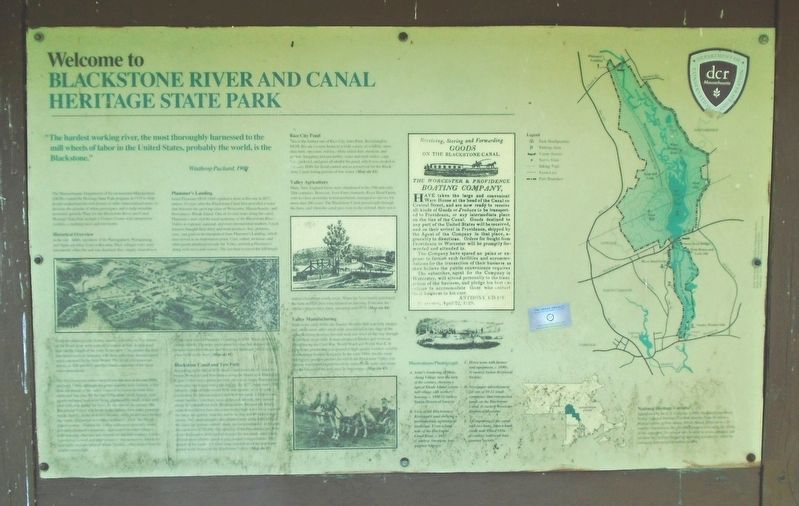
"The hardest working river, the most thoroughly harnessed to the mill wheels of labor in the United States, probably the world, is the Blackstone."
Winthrop Packard, 1909
The Massachusetts Department of Environmental Management (DEM) created the Heritage State Park program in 1978 to help people understand the rich history of older industrialized areas, to increase the amount of urban greenspace and to help stimulate economic growth. Plans for the Blackstone River and Canal Heritage State Park include a Visitor Center with interpretive exhibits, a meeting room and rest rooms.
Historical Overview
In the early 1600s, members of the Narragansett, Wampanoag, and Nipmuck tribes lived in this area. Their villages were semi-permanent; when the soil was depleted, they simply cleared new fields for planting corn, beans, squash, and tobacco. The waters of the Blackstone were a plentiful source of fish. A well-used trail ran the length of the river. In the early 17th century the first Europeans arrived, bringing with them infectious diseases previously unknown in the New World. The result was major epidemics in 1616 and 1633
this page online
The first European settlers moved into the area in the late 1600s and early 1700s; although the great majority were farmers, a few took advantage of the valley's natural resources to mine limestone and bog iron. By the late 1700s, flour, meal, boards, iron goods and hand tools were being produced by small, water-powered mills that dotted the river. By the turn of the century, the Blackstone Valley was home to the nation's first water-powered textile factory. In the next few decades, mills proliferated through the valley. Organized according to what is called "the Rhode Island system," Blackstone Valley mills were generally small, privately financed enterprises, surrounded by entire villages, with housing, churches and schools for the mill workers. Unlike factories in Lowell and other towns in Massachusetts, Rhode Island mills used the labor of whole families, often drawn from the nearby countryside.
Plummer's Landing
Israel Plummer (1810-1888) opened a store at this site in 1837, almost 10 years after the Blackstone Canal first provided a water link between the growing cities
Blackstone Canal and Tow Path
Beginning in the fall of 1828, boats could travel the 45 miles between Worcester and Providence along the brand new Blackstone Canal. Tolls were a penny per mile per ton of cargo. Planning and surveying had begun four years before. By 1827, more than 1,000 laborers, most of them recent Irish immigrants, were at work excavating the Massachusetts
Rice City Pond
This is the former site of Rice City Auto Parts. Reclaimed by DEM, this area is now home to a wide variety of wildlife; snowshoe hare, opossum, red fox, white-tailed deer, muskrat, and raccoon. Snapping and sun turtles, water and mud snakes, carp, bass, pickerel, and pout all inhabit the pond, which was created in the early 1800s for flood control and as a reservoir for the
Valley Agriculture
Many New England farms were abandoned in the 19th and early 20th centuries. However, Voss Farm (formerly River Bend Farm), with its close proximity to transportation, managed to survive for more than 200 years. The Blackstone Canal passed right through the farm, and when the canal gave way to the railroad, there was a station closer than a mile away. When the Voss family purchased the farm in 1920, they concentrated on dairying. It became the region's largest dairy farm, operating until 1974. (Map site #4)
Valley Manufacturing
Built in the early 1850s, the Stanley Woolen Mill was fully integrated; while most other small mills specialized in one stage of the manufacturing process, this mill took raw wool all the way through to finished, dyed cloth. It mass-produced blanket and overcoat fabric during the Civil War, World War I and World War II. In peacetime, production was geared to high-quality woolen used by international fashion designers. In the early 1900s, locally made machinery—another product for which the Blackstone Valley was known—was
Illustration/Photograph
A. Artist's rendering of Manchaug Village near the turn of the century, showing a typical Rhode Island system mill village with workers' housing. c. 1890. (Courtesy Sutton Historical Society)
B. View of the Blackstone River and Canal showing a pre-industrial, agricultural landscape. From a bank note of the Blackstone Canal Bank, c. 1833. (Courtesy American Antiquarian Society)
C. Horse team with farmer and equipment, c. 1890s. (Courtesy Sutton Historical Society)
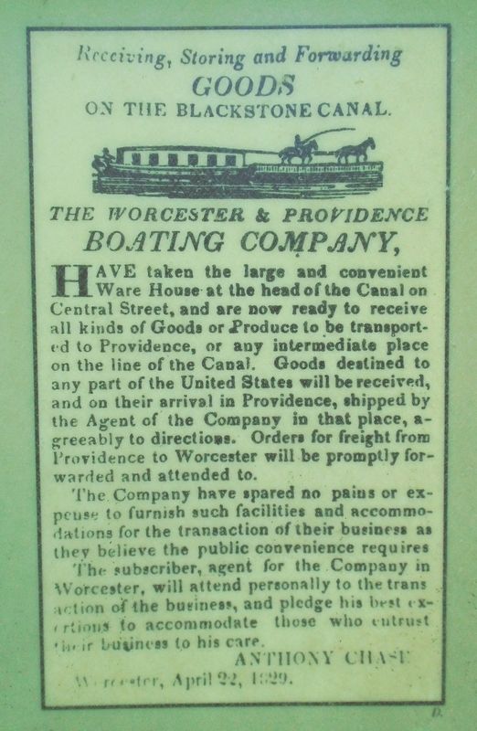
D. Newspaper advertisement for one of 10-12 small companies that transported goods on the Blackstone Canal. (Courtesy Worcester Historical Museum)
E. An engraving of the canal with two boats, from a bank credit note. Dated 1836. (Courtesy American Antiquarian Society)
National Heritage Corridor
Established by the U.S. Congress in 1986, the Blackstone River Valley National Heritage Corridor stretches from Worcester, Massachusetts, to Providence, Rhode Island. Directed by a 19-member commission, the corridor's purpose is to unify the efforts of two states and 20 communities in order to retain, enhance, and interpret the corridor's historical and natural resources, while encouraging appropriate economic growth.
Erected by Massachusetts Department of Conservation and Recreation.
Topics. This historical marker is listed in these topic lists: Industry & Commerce • Parks & Recreational Areas • Railroads & Streetcars • Waterways & Vessels. A significant historical year for this entry is 1909.
Location. 42° 7.679′ N, 71° 38.327′ W. Marker is in Whitinsville, Massachusetts, in Worcester County. It is on Church Street Extension half a mile east of Providence Road (Massachusetts Route 122), on the right when traveling east. Touch for map. Marker is at or near this postal address: Larkin Memorial Recreation Area Parking Lot, Whitinsville MA 01588, United States of America. Touch for directions.
Regionally, this marker is in Massachusetts’ Quiet Corner, in Greater Worcester, and in the Blackstone Valley. It is also in the American Northeast and in New England. Globally, it is in North America, the Western Hemisphere, the Western World, and the Anglosphere. Historically, it finds itself in what was once one of the original Thirteen Colonies.
Other nearby markers. At least 8 other markers are within 2 miles of this marker, measured as the crow flies: Blackstone Canal (within shouting distance of this marker); Plummer's Landing (within shouting distance of this marker); Thomas J. Melia, Jr. (approx. 1.7 miles away); Whitinsville Social Library (approx. 1.7 miles away); David P. Casey (approx. 1.8 miles away); Civil War Memorial (approx. 1.8 miles away); Veterans Memorial (approx. 1.8 miles away); Vietnam War Memorial (approx. 1.8 miles away). Touch for a list and map of all markers in Whitinsville.
Also see . . .
1. Blackstone River and Canal Heritage State Park. (Submitted on May 19, 2018, by William Fischer, Jr. of Reynoldsburg, Ohio.)
2. Blackstone River and Canal Heritage State Park at Wikipedia. (Submitted on May 19, 2018, by William Fischer, Jr. of Reynoldsburg, Ohio.)
Credits. This page was last revised on May 19, 2018. It was originally submitted on May 19, 2018, by William Fischer, Jr. of Reynoldsburg, Ohio. This page has been viewed 838 times since then and 39 times this year. Photos: 1, 2, 3, 4. submitted on May 19, 2018, by William Fischer, Jr. of Reynoldsburg, Ohio.
