Harnessing Waterpower
Boott Dam
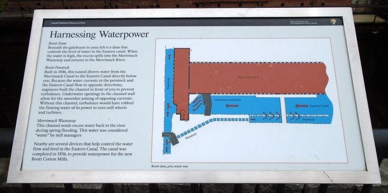
Beneath the gatehouse to your left is a dam that controls the level of water in the Eastern canal. When the water is high, the excess spills into the Merrimack Wasteway and returns to the Merrimack River.
Booth Penstock
Built in 1846, this tunnel diverts water from the Merrimack Canal to the Eastern Canal directly below you. Because the water currents in the penstock and the Eastern Canal flow in opposite directions, engineers built the channel in front of you to prevent turbulence. Underwater openings in the channel wall allow for the smoother joining of opposite currents. Without this channel, turbulence would have robbed the flowing water of its power to turn mill wheels and turbines.
Merrimack Wasteway
This channel sends excess water back to the river during spring flooding. This was was considered "waste" by mill managers.
Nearby are several devices that help control the water flow and level in the Eastern Canal. The canal was completed in 1836, to provide waterpower for the new Boott Cotton Mills.
[Illustration caption reads]
Boott dam, pen, waste way
Erected by National Park Service.
Topics. This historical marker is listed in these topic lists: Industry & Commerce • Waterways & Vessels. A significant historical year for this entry is 1846.
Location.
Other nearby markers. At least 8 other markers are within walking distance of this marker. In the Shadow of the Mills (within shouting distance of this marker); The Lowell Sculptures: One, Two, and Three (within shouting distance of this marker); The Rule of the Bell (within shouting distance of this marker); Florence Patti Marion (about 300 feet away, measured in a direct line); Evolution of a Millyard (about 300 feet away); The Birth of an Industrial City (about 400 feet away); W.H. Parker Building (about 500 feet away); Brown, Fay, and Watson Houses (about 500 feet away). Touch for a list and map of all markers in Lowell.
Also see . . . Water Power (Lowell National Historical Park). (Submitted on May 26, 2018, by William Fischer, Jr. of Scranton, Pennsylvania.)
Credits. This page was last revised on October 8, 2020. It was originally submitted on May 26, 2018, by William Fischer, Jr. of Scranton, Pennsylvania. This page has been viewed 169 times since then and 10 times this year. Photos: 1, 2. submitted on May 26, 2018, by William Fischer, Jr. of Scranton, Pennsylvania.

