Near Pocahontas in Hinds County, Mississippi — The American South (East South Central)
Landscape Modification in Prehistoric Times
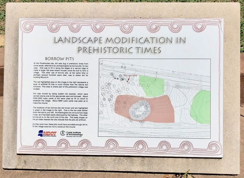
The red highlighted area on the image to the right represents a layer of artificial fill that is much thicker than the natural soil horizons. This area is where part of the prehistoric village was located.
Dirt was moved by being loaded into baskets, which were carried one-by-one to the appropriate spot and dumped. About 2000-3000 cubic yards of dirt were used as fill on which to establish the village. About 9000 cubic yards was piled up to make the mound.
The locations of two borrow pits are known and are highlighted in green in the image to the right. One is the low area farther down the trail to your left. Archaeologists are not sure how large it was, as it has been partly destroyed by the highway. The other borrow pit is on the north end of the site. The steep slopes on the pit sides nearest the site indicate that the pits are artificial.
As they exist now, these pits could have provided enough dirt to fill the village area but not to construct the mound.
Erected by Mississippi Department of Transportation, Cobb Institute of Archaeology-Mississippi State University.
Topics. This historical marker is listed in these topic lists: Anthropology & Archaeology • Native Americans.
Location. 32° 28.129′ N, 90° 17.341′ W. Marker is near Pocahontas, Mississippi, in Hinds County. Marker can be reached from U.S. 49, 0.8 miles south of Kennebrew Road, in the median. Located at Pocahontas Mounds Roadside Park. Touch for map. Marker is in this post office area: Jackson MS 39209, United States of America. Touch for directions.
Other nearby markers. At least 8 other markers are within 6 miles of this marker, measured as the crow flies. Ceremonial Mounds Of The Southeast (a few steps from this marker); Midden: Sifting Through the Trash (about 300 feet away, measured in a direct line); Pocahontas Mounds (about 400 feet away); The Evolution of the Pocahontas Site (about 500 feet away); Environmental Archaeology (about 700 feet away); a different marker also named Pocahontas Mounds (about 700 feet away); Stone Fence Posts Mid-Western Kansas 1880’s (approx. 3.7 miles away); Osburn Stand (approx. 5.9 miles away). Touch for a list and map of all markers in Pocahontas.
Also see . . . Wikipedia article on the Pocahontas Mounds. (Submitted on August 10, 2018, by Mark Hilton of Montgomery, Alabama.)
Credits. This page was last revised on December 16, 2020. It was originally submitted on August 10, 2018, by Mark Hilton of Montgomery, Alabama. This page has been viewed 139 times since then and 12 times this year. Photos: 1, 2, 3, 4. submitted on August 10, 2018, by Mark Hilton of Montgomery, Alabama.


