Clarksville in Montgomery County, Tennessee — The American South (East South Central)
Town of Cumberland
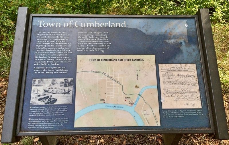
A major road ran up the hill and between what is now Fort Defiance and Trice's Landing. Another road paralleled the Red River to a ford, and later, a bridge connecting to Clarksville. By the early 1840s, the towns of Meachamsville and New Providence developed along these routes and their connecting roads at the top of New Providence Hill. The area was a flourishing commercial center prior to the Civil War.
Photo captions:
A Keelboats, designed to travel upstream, measured about 60 feet long by 8 feet wide. Although equipped with a sail, they often had to be rowed, poled or hand winched upstream. Travel from New Orleans to Clarksville by keelboat took three to four months.
B Flatboats, designed to travel downstream, measured about 50 feet long and 12 feet wide. They were navigated by a huge stern oar and three outer steering oars. After reaching their destination, flatboats were usually dismantled and sold as scrap lumber.
Far right:Receipt dated October 12, 1859 from New Fireproof Tobacco Warehouse at Red River Landing assures shipment of 250 barrels of flour to New Orleans aboard the steamboat Ella at the cost of sixty cents per barrel.
Erected 2008 by the City of Clarksville.
Topics. This historical marker is listed in these topic lists: Roads & Vehicles • Settlements & Settlers • Waterways & Vessels. A significant historical date for this entry is October 12, 1859.
Location. 36° 32.403′ N, 87° 22.351′ W. Marker is in Clarksville, Tennessee, in Montgomery County. Marker can be reached from Duncan Street, 0.2 miles south of Walker Street. Touch for map. Marker is at or near this postal address: 120 Duncan Street, Clarksville TN 37042, United States of America. Touch for directions.
Other nearby markers. At least 8 other markers are within walking distance of this marker. Tobacco Trade and the Rivers (within shouting distance of this marker); Freedmen's Camp and the USCT (about 400 feet away, measured in a direct line); Life as a Garrisoned Union Soldier (about 400 feet away); Bringing the War to Clarksville (about 500 feet away); Building Fort Sevier (Defiance) (about 500 feet away); Forts Versus Ironclads (about 600 feet away); Fort Defiance Interpretive Center (about 600 feet away); Fort Defiance (about 700 feet away). Touch for a list and map of all markers in Clarksville.
Credits. This page was last revised on February 26, 2022. It was originally submitted on September 4, 2018, by Mark Hilton of Montgomery, Alabama. This page has been viewed 314 times since then and 15 times this year. Photos: 1. submitted on September 4, 2018, by Mark Hilton of Montgomery, Alabama. 2. submitted on February 26, 2022, by Darren Jefferson Clay of Duluth, Georgia. 3. submitted on September 4, 2018, by Mark Hilton of Montgomery, Alabama.


