Aberdeen in Harford County, Maryland — The American Northeast (Mid-Atlantic)
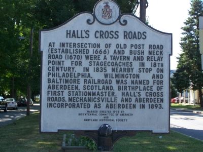
Hall’s Cross Roads
Erected 1976 by Bicentennial Committee of Aberdeen & Maryland Historical Society.
Topics. This historical marker is listed in these topic lists: Colonial Era • Political Subdivisions • Railroads & Streetcars • Roads & Vehicles. A significant historical year for this entry is 1835.
Location. 39° 30.459′ N, 76° 9.581′ W. Marker is in Aberdeen, Maryland, in Harford County. Marker is at the intersection of East Bel Air Ave and Post Road, on the left when traveling east on East Bel Air Ave. Touch for map. Marker is in this post office area: Aberdeen MD 21001, United States of America. Touch for directions.
Other nearby markers. At least 8 other markers are within walking distance of this marker. This is a Section of “The General’s Highway” (approx. ¼ mile away); Aberdeen Proving Ground (approx. ¼ mile away); Aberdeen 9/11 Memorial (approx. 0.3 miles away); Aberdeen Proving Ground Memorial (approx. 0.3 miles away); 2008 Restoration of P.B. & W. Railroad Crossing and Later Pennsylvania Railroad Watchman's Shed (approx. 0.4 miles away); ENIAC (approx. 0.4 miles away); Aberdeen Veterans Memorial (approx. 0.4 miles away); James B. Baker House (approx. ¾ mile away). Touch for a list and map of all markers in Aberdeen.
Additional commentary.
1. Railroads in Aberdeen
The tracks of the Philadelphia, Wilmington and Baltimore Railroad mentioned on the marker became part of the Pennsylvania Railroad and now form part of Amtrak’s Northeast Corridor between Washington and Boston. Aberdeen was also served by the Baltimore and Ohio Railroad, now part of CSX. In the first half of the 20th century, dozens of passenger trains a day stopped at Aberdeen en route between Washington and New York. Even today twelve Amtrak trains stop at Aberdeen daily.
— Submitted June 24, 2007, by J. J. Prats of Powell, Ohio.
Credits. This page was last revised on June 16, 2016. It was originally submitted on June 24, 2007, by Bill Pfingsten of Bel Air, Maryland. This page has been viewed 4,175 times since then and 95 times this year. Photos: 1, 2. submitted on June 24, 2007, by Bill Pfingsten of Bel Air, Maryland. • J. J. Prats was the editor who published this page.

