Alster Tower & Peristyle

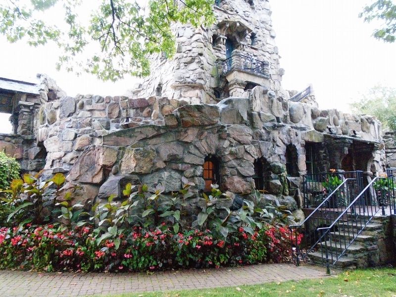
In 1895 George Boldt acquired Heart Island for the reputed sum of $20,000.00 and work on the Island began shortly thereafter. The first three projects undertaken were the design and construction of Alster Tower, the construction of a boat lagoon and Peristyle and the reconstruction of the original Hart House. On July 15, 1899 Mr. Boldt formally opened what he called "Alster Tower" which is said to be a replica of a castle on the Rhine River in Germany. As the first project completed on the Island, Alster Tower's success provided the inspiration for the monumental projects subsequently initiated by Mr. Boldt. It was intended for recreational purposes and as guest quarters. On the first floor is the "Shell Room" so-called because of its shell shaped ceiling. It was used for musicals and dancing while in the basement below is a two lane bowling alley. The upper floors contained a billiard room, library, cafe and kitchen. The tower was the only new structure on Heart Island that was completed and it is said the Boldts lived here while construction of the castle was underway. At the foot of the tower was located a dock for
this page online
By 1899 Mr. Boldt hired the Philadelphia, Pennsylvania architects, G. W. and W. D. Hewitt to assist him in the design of several major projects on the island. The Architects were told that expense was a minor consideration and many of the ideas and inspirations came from the Boldts. It is not known if the Hewitts participated in the design of Alster Tower, however, it is known that the Peristyle is attributable to them. The Peristyle, built of huge masses of granite, was built out into the water in such a way as to make the heart shape of the Island more pronounced. In the middle of the Peristyle a large arch resembling the Arch of Triumph was built which was to be capped with a number of carved stone male deer known as "harts." The "hart" is a symbol of George Boldt's European lineage and part of the family's coat of arms. It is symbolized in the architecture throughout Heart Island. The arch served as a water gate which was to be the formal entrance for launches delivering guests. The lagoon is over 500 feet in length and 100 feet at its widest

Erected by Thousand Islands Bridge Authority.
Topics. This historical marker is listed in these topic lists: Architecture • Entertainment • Man-Made Features • Waterways & Vessels. A significant historical date for this entry is July 15, 1899.
Location. 44° 20.64′ N, 75° 55.383′ W. Marker is on Heart Island, New York, in Jefferson County. It can be reached from Heart Island. Marker is on the Boldt Castle grounds, only accessible by boat as it sits on Heart Island in the Saint Lawrence River. Touch for map. Marker is in this post office area: Alexandria Bay NY 13607, United States of America. Touch for directions.

Regionally, this marker is in Upstate New York and in the Adirondacks & North Country. It is also in the American Northeast and in the Mid-Atlantic. Globally, it is in North America, on the Great Lakes, in the Western Hemisphere,

Other nearby markers. At least 8 other markers are within walking distance of this marker: Swan Pond (within shouting distance of this marker); Grand Entrance (within shouting distance of this marker); The Seaway (within shouting distance of this marker); Yacht House & Wellesley Island (about 300 feet away, measured in a direct line); Dovecote & Garden (about 400 feet away); Boldt Castle (about 400 feet away); Power House (about 600 feet away); Cornwall Brothers Store (approx. 0.4 miles away). Touch for a list and map of all markers in Heart Island.
Also see . . . Boldt Castle History. (Submitted on November 23, 2018, by William Fischer, Jr. of Reynoldsburg, Ohio.)


Credits. This page was last revised on November 23, 2018. It was originally submitted on November 23, 2018, by William Fischer, Jr. of Reynoldsburg, Ohio. This page has been viewed 749 times since then and 50 times this year. Photos: 1, 2, 3, 4, 5, 6. submitted on November 23, 2018, by William Fischer, Jr. of Reynoldsburg, Ohio.
