
Near Conowingo in Cecil County, Maryland — The American Northeast (Mid-Atlantic)
Bald Friar Ford & Ferry
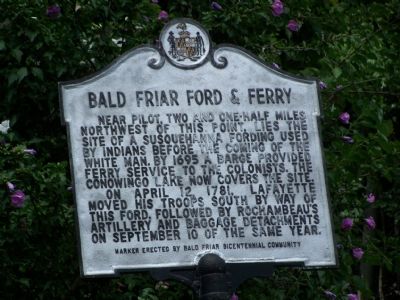
Photographed by Beverly Pfingsten, July 21, 2007
1. Bald Friar Ford & Ferry Marker
The ford is now at the bottom of Conowingo Lake following the construction of Conowingo Dam in the 1920's.
On April 12, 1781, Lafayette moved his troops south by way of this ford, followed by Rochambeau’s Artillery and baggage detachments on September 10 of the same year.
Erected by Bald Friar Bicentennial Community.
Topics and series. This historical marker is listed in these topic lists: Colonial Era • Indigenous Peoples and Communities • War, US Revolutionary • Waterways & Vessels. In addition, it is included in the The Washington-Rochambeau Route series list. A significant historical month for this entry is April 1900.
Location. 39° 41.949′ N, 76° 10.442′ W. Marker is near Conowingo, Maryland, in Cecil County. It is at the intersection of Rock Springs Road (U.S. 222) and Old Conowingo Road, on the left when traveling north on Rock Springs Road. Touch for map. Marker is in this post office area: Conowingo MD 21918, United States of America. Touch for directions.

Regionally,
this page online
Other nearby markers. At least 8 other markers are within 4 miles of this marker, measured as the crow flies: St. Patrick's Chapel (approx. 1.9 miles away); A Susquehannock Indian Fort (approx. 2.7 miles away); Conowingo (approx. 3.1 miles away); Berkley Crossroads (approx. 3.2 miles away); Susquehanna River fishing (approx. 3.3 miles away); Lafayette at Colonel Rigbie’s House (approx. 3.3 miles away); Richards Oak (approx. 3½ miles away); The Proprietors of the Susquehanna Canal (approx. 3.8 miles away). Touch for a list and map of all markers in Conowingo.
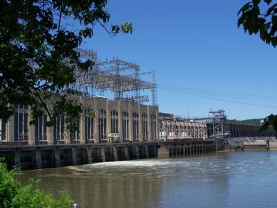
Photographed by Beverly Pfingsten, July 1, 2007
2. Conowingo Dam
Credits. This page was last revised on January 1, 2019. It was originally submitted on July 21, 2007, by Bill Pfingsten of Bel Air, Maryland. This page has been viewed 4,454 times since then and 133 times this year. Last updated on December 29, 2018, by Carl Gordon Moore Jr. of North East, Maryland. Photos: 1, 2. submitted on July 21, 2007, by Bill Pfingsten of Bel Air, Maryland. • Andrew Ruppenstein was the editor who published this page.
