Clarkston in Asotin County, Washington — The American West (Northwest)
Granite Lake Park
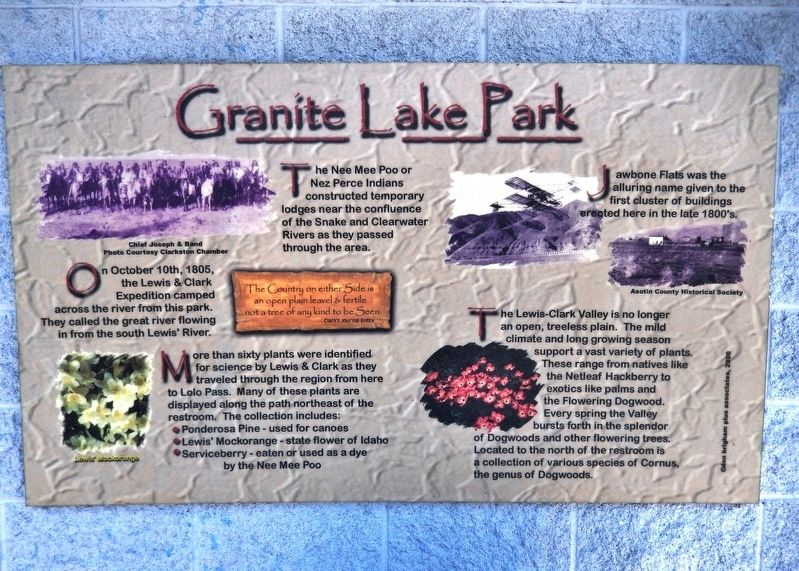
”The Country on either Side is an open plain leavel & Fertile …not a tree of any kind to be seen.”
Clark’s Journal Entry
More than sixty plants were identified for science by Lewis & Clark as they traveled through the region from here to Lolo Pass. Many of these plants are displayed along the path northeast of the restroom. The collection includes:
• Ponderosa Pine - used for canoes
• Lewis’ Mockorange - state flower of Idaho
• Serviceberry - eaten or used as a dye by the Nee Mee Poo
The Nee Mee Poo or Nez Perce Indians constructed temporary lodges near the confluence of the Snake and Clearwater Rivers as they passed through the area.
Jawbone Flats was the alluring name given to the first cluster of buildings erected here in the late 1800’s.
The Lewis-Clark Valley is no longer an open, treeless plain. The mild climate and long growing season support a vast variety of plants. These range from natives like the Netleaf Hackberry to exotics like palms and the Flowering Dogwood. Every spring the Valley bursts forth in the splendor of Dogwoods and other flowering trees. Located to the north of the restroom is a collection of various species of Cornus, the genus of Dogwoods.
marker picture captions:
• Chief Joseph & Band - Photo Courtesy Clarkston Chamber
• Lewis’ Mockorange
• Asotin County Historical Society
Topics and series. This historical marker is listed in these topic lists: Exploration • Native Americans • Waterways & Vessels. In addition, it is included in the Lewis & Clark Expedition series list. A significant historical date for this entry is October 10, 1805.
Location. 46° 25.565′ N, 117° 2.934′ W. Marker is in Clarkston, Washington, in Asotin County. Marker can be reached from the intersection of Port Way and 9th Street, on the left when traveling east. Marker is located in Granite Lake Park, on the south side of the park restroom building. Touch for map. Marker is at or near this postal address: 845 Port Way, Clarkston WA 99403, United States of America. Touch for directions.
Other nearby markers. At least 8 other markers are within walking distance of this marker. Lewis & Clark Almost Slept Here (a few steps from this marker); Lewis and Clark (within shouting distance of this marker); Nimiipuu Homelands (approx. half a mile away); a different marker also named Lewis and Clark (approx. 0.7 miles away in Idaho); Lewiston's Chinese Community (approx. 0.8 miles away in Idaho); Tsceminicum (approx. 0.9 miles away in Idaho); Firsts in Lewiston (approx. 0.9 miles away in Idaho); Kettenbach Building (approx. 0.9 miles away in Idaho). Touch for a list and map of all markers in Clarkston.
More about this marker. Marker is a large composite plaque, mounted at eye-level on the south side of the park restroom building.
Also see . . .
1. Journals of the Lewis & Clark Expedition: October 10, 1805. Clark: "We halted a Short time above the Point and Smoked with the Indians, & examined the Point and best place for our Camp, we Camped on the Columbia River a little above the point... I Saw about 200 men Comeing down from their villages & were turned back by the Chief, after we built our fires of what wood we Could Collect, & get from the Indians, the Chief brought down all his men Singing and dancing as they Came, formed a ring and danced for Some time around us... we gave them a Smoke... bought 7 dogs & they gave us Several fresh Salmon..." (Submitted on January 24, 2019, by Cosmos Mariner of Cape Canaveral, Florida.)
2. Asotin County Thumbnail History: Jawbone Flat. Asotin County's growth was assured in 1896 by the construction of an 18-mile-long irrigation canal running from Asotin Creek above Asotin to Jawbone Flat, an area of potentially fertile - but at that time barren - land along the Snake River in and to the west of present-day Clarkston. On July 18, 1896, the canal began providing water to Jawbone Flat, and the effect it had on the area was remarkable: Population of the area that would soon become Clarkston boomed from perhaps 15 people in 1896 to approximately 2,200 in 1903. (Submitted on January 24, 2019, by Cosmos Mariner of Cape Canaveral, Florida.)
Credits. This page was last revised on January 29, 2019. It was originally submitted on January 24, 2019, by Cosmos Mariner of Cape Canaveral, Florida. This page has been viewed 330 times since then and 31 times this year. Photo 1. submitted on January 24, 2019, by Cosmos Mariner of Cape Canaveral, Florida. • Andrew Ruppenstein was the editor who published this page.
