Homestead in Miami-Dade County, Florida — The American South (South Atlantic)
The Edge of Discovery
⎯⎯⎯
Margen del Descubrimiento
Photographed by Cosmos Mariner, January 15, 2015
1. The Edge of Discovery / Margen del Descubrimiento Marker
The Edge of Discovery (English)
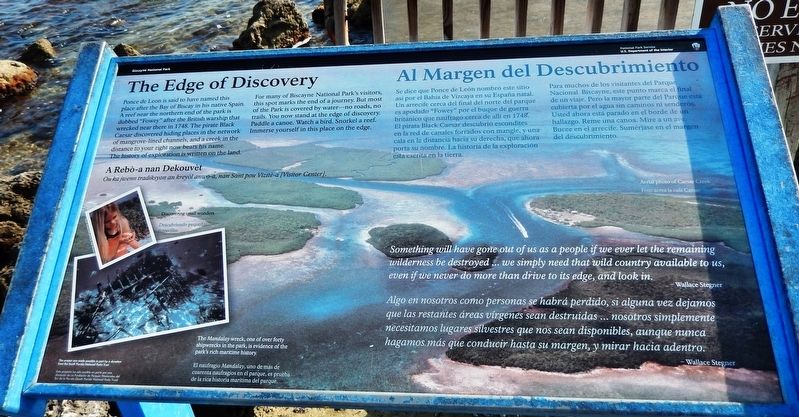
Ponce de Leon is said to have named this place after the Bay of Biscay in his native Spain. A reef near the northern end of the park is dubbed “Fowey” after the British warship that wrecked near there in 1748. The pirate Black Caesar discovered hiding places in the network of mangrove-lined channels, and a creek in the distance to your right now bears his name. The history of exploration is written on the land.
For many of Biscayne National Park's visitors, this spot marks the end of a journey. But most of the Park is covered by water — no roads, no trails. You now stand at the edge of discovery. Paddle a canoe. Watch a bird. Snorkel a reef. Immerse yourself in this place on the edge.
Al Margen del Descubrimiento (Spanish)
Se dice que Ponce de León nombró este sitio así por el Bahia de Vizcaya en su España natal. Un arrecife cerca del final del norte del parque es apodado "Fowey" por el buque de guerra británico que naufragó cerca de allí en 1748. El pirata Black Caesar descubrió escondites en la red de canales forrados con mangle, y una cala en la distancia hacia su
this page online
Para muchos de los visitantes del Parque Nacional Biscayne, este punto marca el final de un viaje. Pero la mayor parte del Parque está cubierta por el agua sin caminos ni senderos. Usted ahora está parado en el borde de hallazgo. Reme una canoa. Mire a un ave. Bucee en el arrecife. Sumérjase en el margen del descubrimiento.
A Rebó-a nan Dekouvét
Ou ka jwenn tradiksyon an kreyól anwo-a, nan Sant pou Vizité-a [Visitor Center]
Something will have gone out of us as a people if we ever let the remaining wilderness be destroyed… we simply need that wild country available to us, even if we never do more than drive to its edge, and look in.
- Wallace Stegner
Algo en nosotros como personas se habrá perdido, si alguna vez dejamos que las restantes áreas vírgenes sean destruidas… nosotros simplemente necesitamos lugares silvestres que nos sean disponibles, aunque nunca hagamos más que conducir hasta su margen, y mirar hacia adentro.
- Wallace Stegner
(background image caption)
Aerial photo of Caesar Creek
Foto aerea la cala Caesar
(photo captions)
Discovering
Photographed by Cosmos Mariner, January 15, 2015
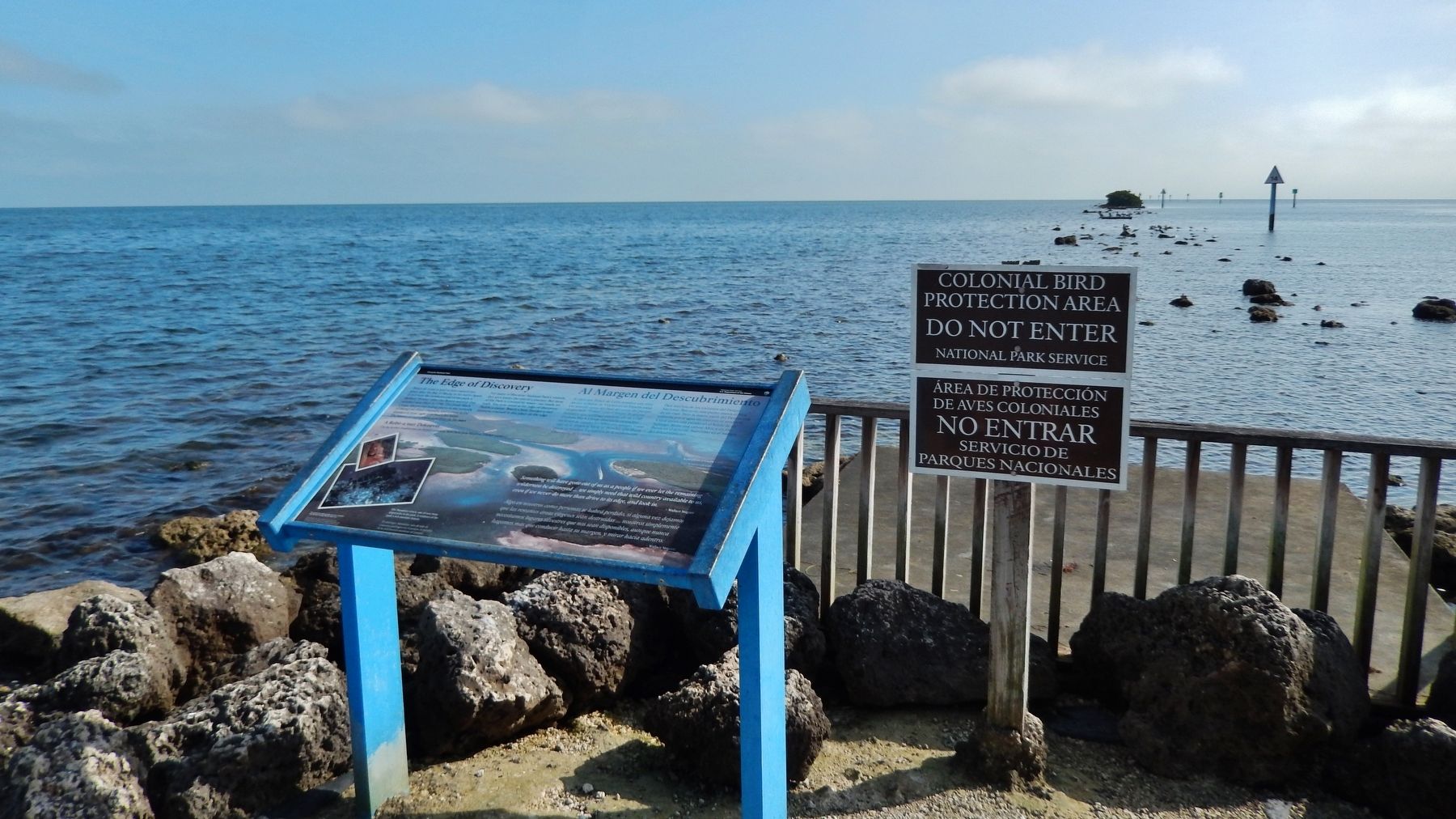
2. The Edge of Discovery Marker (wide view; looking east across Biscayne Bay)
Descubriendo pequeñas maravillas
The Mandalay wreck, one of over forty shipwrecks in the park, is evidence of the park’s rich maritime history.
El naufragio Mandalay, uno de más de cuarenta naufragios en el parque, es prueba de la rica historia marítima del parque.
Este proyecto fue posible en parte gracias a una donación del South Florida National Parks Trust.
Erected by National Park Service, U.S. Department of the Interior.
Topics. This historical marker is listed in these topic lists: Exploration • Parks & Recreational Areas • Waterways & Vessels.
Location. 25° 27.802′ N, 80° 19.861′ W. Marker is in Homestead, Florida, in Miami-Dade County. It can be reached from Southwest 328th Street 2.8 miles east of Southwest 117th Avenue (Colonial Road) when traveling east. Marker is located at the east end of the Maritime Heritage Trail, near the Dante Fascell Visitor Center in Biscayne National Park. Touch for map. Marker is at or near this postal address: 9700 Southwest 328th Street, Homestead FL 33033, United States of America. Touch for directions.

Regionally, this marker is in South Florida, on the Gold Coast, and in Greater Miami. It is also in the American South and on the Eastern Seaboard. Globally, it is in the North Atlantic Region, North America, a Gulf of Mexico state, the Western Hemisphere, the Western World, and the Anglosphere. Historically, it finds itself in what was once New Spain, the territory of the Mississippian Culture, one of the Confederate States of America, and the Antebellum South.
Other nearby markers. At least 8 other markers are within walking distance of this marker: A Sudden Squall (approx. 0.2 miles away); Ring the Biscayne Channel Sea Bell! (approx. 0.2 miles away); Two Parks, Divided (approx. 0.2 miles away); The Jones Family of Biscayne (approx. 0.2 miles away); Maritime Heritage Trail (approx. ¼ mile away); The Edge of "Progress" / Al Margen del "Progreso" (approx. ¼ mile away); HMS Fowey Cannon (approx. ¼ mile away); His Majesty's Ship Fowey (approx. ¼ mile away). Touch for a list and map of all markers in Homestead.
Also see . . .
1. Mandalay Wreck, Key Biscayne. The Mandalay was a 128 foot steel schooner. While en route from a ten day Bahamas cruise on New Years Day, 1966, with all 23 passengers and crew sound asleep, the Mandalay went hard aground at 3:00 AM. Heavy seas almost capsized her as the Coast Guard helicopters rushed to the scene where fortunately all passengers and crew were rescued. (Submitted on April 6, 2019, by Cosmos Mariner of Cape Canaveral, Florida.)
2. Youtube video of Mandalay wreck dive (1.5 min.). (Submitted on April 6, 2019, by Cosmos Mariner of Cape Canaveral, Florida.)
Credits. This page was last revised on October 27, 2020. It was originally submitted on April 6, 2019, by Cosmos Mariner of Cape Canaveral, Florida. This page has been viewed 421 times since then and 32 times this year. Photos: 1, 2. submitted on April 6, 2019, by Cosmos Mariner of Cape Canaveral, Florida.
