The Fan District in Richmond, Virginia — The American South (Mid-Atlantic)
Monroe Park
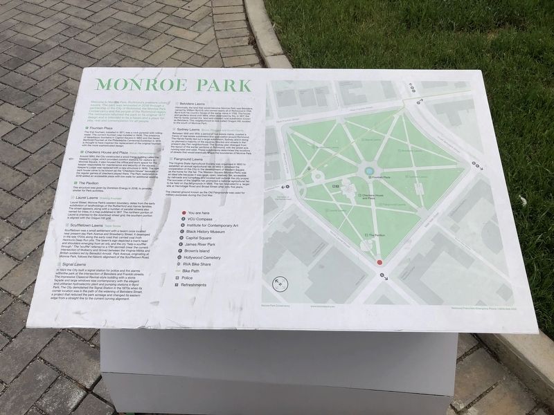
Welcome to Monroe Park, Richmond's premiere urban square. The park was renovated in 2018 through a partnership of the City of Richmond, the Monroe Park Conservancy and the people of the Richmond region. The renovation returned the park to its original 1877 design and is intended to be a haven and a place for play, rest and contemplation for all people.
1. Fountain Plaza
The first fountain, installed in 1871, was a rock pyramid with rolling water. The current fountain was installed in 1906. The presence of tiered tazzo fountains in Capitol Square in 1860 and the tiered Bartholdi Fountain at the Philadelphia Centennial Exhibition in 1876 is thought to have inspired the replacement of the original fountain with the more sophisticated design.
2. Checkers House and Plaza Police | Refreshments
Around 1890, the City constructed a wood frame building called the Keeper's Lodge, which provided comfort stations for visitors to Monroe Square. It also housed the official work space for the keeper responsible for maintenance and security of the square. Keeper's Lodge was replaced with a new structure in 1939. The new park house came to be known as the "Checkers House" because of the regular games of checkers played there. The Park restoration in 2018 added an accessible plaza with low walls for additional seating.
3. The Pavilion
This structure was given by Dominion Energy in 2018, to provide shelter for Park activities.
4. Laurel Lawns Drinking Fountain
Laurel Street, Monroe Park's western boundary, dates from the early subdivision of landholdings of the Rutherford and Harvie families. The street appears, along with a number of parallel streets also named for trees, in a map published in 1817. The northern portion of Laurel is oriented to the downtown street grid; the southern portion is aligned with the Oregon Hill grid.
5. Scuffletown Lawns Table Tennis
Scuffletown was a small settlement with a tavern once located near present-day Park Avenue and Strawberry Street. It developed in the late 1700s along the early road that carried coal from Henrico's Deep Run pits. The tavern's sign depicted a man's head and shoulders emerging from an orb, and the cry "help a scuffler through." The "scuffle" referred to a 1781 skirmish (near the current intersection of Mulberry and Grove) between the Virginia Militia and British soldiers led by Benedict Arnold. Park Avenue, originating at Monroe Park, follows the historic alignment of the Scuffletown Road.
6. Signal Lawns
In 1923 the City built a signal station for police and fire alarms within the park
7. Belvidere Lawns
Historically, the land that would become Monroe Park was Belvidere, named by William Byrd III, who owned nearly all of Richmond in 1745. Byrd built his country house of the same name in 1758. The house and gardens stood until 1854, when destroyed the fire. In 1817, the Harvie family owned the land and created rural subdivision known as Belvidera. The neighborhood is now called Oregon Hill, located to the south of Monroe Park.
8. Sydney Lawns Bocce, Pétanque and Quoits Courts
Between 1816 and 1819, a period of real estate mania, created a frenzy of real estate subdivision and speculation around Richmond. The Harvie Family laid out a large subdivision, Sydney, and in doing so planned a majority of the squares (blocks) and streets in the Present-day Fan neighborhood. The Sydney plan diverged from the layout of the earlier sections of Richmond, with the street axis running east and west. These subdivisions determined the locations of streets that would eventually shape the boundaries of Monroe Park.
9. Fairground Lawns
The Virginia State Agricultural Society was organized in 1850 to establish an annual agricultural fair. In 1853 it obtained the cooperation of the City in development of Western Square as the home for the fair. The Western Square (Monroe Park) was an ideal site because it was large, open, relatively flat, accessible by railroads and turnpikes, and located just outside the city proper. The success of the Virginia fair prompted a national agricultural fair to be held on the fairgrounds in 1858. The fair relocated to a larger site at Hermitage Road and Broad Street after only five years.
The cleared ground known as the Old Fairgrounds was used for military purposes during the Civil War.
Erected 2018 by Monroe Park Conservancy.
Topics. This historical marker is listed in these topic lists: Architecture • Entertainment • Parks & Recreational Areas • Roads & Vehicles. A significant historical year for this entry is 2018.
Location. 37° 32.756′ N, 77° 27.085′ W. Marker is in Richmond, Virginia. It is in The Fan District. Marker is at the intersection of West Main Street (Virginia Route 147) and North Laurel Street on West Main Street. Touch for map. Marker is at or near this postal address: 711 West Main Street, Richmond VA 23220, United States of America. Touch for directions.
Other nearby markers. At least 8 other markers are within walking distance of this marker. A different marker also named Monroe Park (about 400 feet away, measured in a direct line); Cathedral of the Sacred Heart (about 500 feet away); Jacob House (about 700 feet away); Founders Hall (approx. 0.2 miles away); Richmond Professional Institute (approx. 0.2 miles away); Grace Evelyn Arents (approx. 0.3 miles away); The Equal Suffrage League of Virginia (approx. 0.3 miles away); Oregon Hill (approx. 0.3 miles away). Touch for a list and map of all markers in Richmond.
Credits. This page was last revised on June 7, 2023. It was originally submitted on May 11, 2019, by Devry Becker Jones of Washington, District of Columbia. This page has been viewed 227 times since then and 21 times this year. Photos: 1, 2. submitted on May 11, 2019, by Devry Becker Jones of Washington, District of Columbia.

