Chetumal in Othón P. Blanco, Quintana Roo, Mexico — The Yucatan Peninsula (The Southeast)
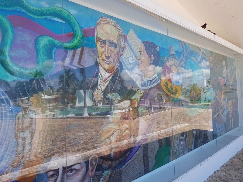
Quintana Roo, from Territory to State
Dimensiones: 2.50 metros de altura por 13.00 metros de largo con un total de 32.50 metros cuadrados.
Técnica: “Isoplástica Carrasco”
Sinopsis
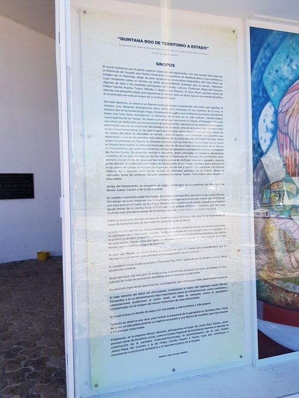
El mural comienza por la parte superior izquierda del espectador, con una versión del mapa de la Peninsula de Yucatán que ilustra claramente la superficie de Quintana Roo y que contiene la imagen de un flamingo, abajo de éste, localizamos la escultura enigmática del Chac Mool, de cuyo recipiente sobre el vientre, se están desprendiendo burbujas que se elevan, indicando algunas de ellas a las ciudades principales del Estado; Cancún, Chetumal, Playa del Carmen, Felipe Carrllo Puerto, Tulum, Alfredo V. Bonfil e Isla Mujeres. El Chac Mool, sostiene entre las piernas una pequeña estela que representa el número cero, es decir, que en un sentido filosófico es el principio de todo el origen de la civilización maya.
Del lado derecho, se observa un Nacom (cacique maya) sosteniendo otro sello, que significa el número uno, después distinguimos otros sellos, uno montado en los cuernos de la luna, el número dos en la numerología maya y finalmente el cuatro, que señala los huracanes apuntando hacia una luna llena, recordemos la influencia de la luna en la vida cultural, meteorológica, cosmogónica de los mayas. Se observa un árbol que representa al ébano, el Huanacaxtle y que sus raices se confunden con la escalinata de una pirámide, para evocar las zonas arqueológicas, patrimonio que no es solamente del Estado o de la nación, sino de la humanidad. Quintana Roo posee importantes áreas en las que el agua que no tiene salida hacia el mar, por ello debajo de las ramas del árbol se descubre un cenote. Junto al cenote está plasmado un cocodrilo que representa a uno de los cenotes más importantes de la zona, lamado Cocodrilo Dorado. Hacia abajo encontramos las figuras de Gonzalo Guerrero con sus tres hijos y a su mujer con un bebé en brazos para ilustrar el inicio del mestizaje, además de la primera naturalización de un ibérico en Mesoamérica, que junto con Gerónimo de Aguilar generaron una leyenda anterior a la llegada de Hernán Cortés. En dirección vertical al cocodrilo, están colocados un caracol y una especie coralífera de las que abundan en los litorales de la Península de Yucatán. Por encima del coral aparece una corriente de agua que ilustra la presencia de múltiples lagunas o aguadas. Hacia la parte inferior, se contempla una escena de fusilamiento de los mayas rebeldes, que
participaron
en la guerra de castas. Se ilustran las efigies de Jacinto Pat y Cecilio Chi, que junto con Manuel
Antonio Ay y algunos otros héroes locales en diferentes periodos de la historia, desde la
conquista hasta las primeras décadas posrevolucionarias fueron torturados, encarcelados o
asesinados.
Arriba del fusilamiento, se encuentra un juego morfológico de la superficie del Municipio de Benito Juárez, Cancún y de la Isla Cozumel.
En sentido ascendente están los bustos de Andrés Quintana Roo, así como el de Leona Vicario. Por debajo de estas imágenes una tortuga Carey, se dirige hacia el escudo estatal, por encima de una vista parcial del fuerte de San Felipe Bacalar, relacionado con la cárcel, a donde se enviaban desde finales de la colonia hasta el Porfiriato, a los presos políticos o rebeldes, por eso está ilustrado este dramático pasaje de la historia nacional y local, con un preso en una jaula.
Sobre la jaula, está ubicada una casa de madera, pues a principios del siglo XX la mayoría de las casas de Chetumal eran de ese material, parecidas a las de Belice.
La cabaña, por decirlo así, está por debajo de un aluvión, producto de las tormentas tropicales. Se distinguen dos especies de animales, la de una variedad de murciélagos como el zapatero, el ciricotero, el vampiro, el guanero y el pescado, el cual va tras el pequeño huachinango que
habita en esta región, incluso ellos son parte de algunas leyendas locales. La otra especie es la del Manatí, que se halla en peligro de extinción.
Al lado del Manatí, un mono araña se recarga en una "T", como una remembranza por la inteligencia que tenian estos primates para resguardarse de los ciclones.
El simpático mono le jala la solapa a Francisco May Pech, quien dirigía la compra y venta de la producción chiclera.
Al pie del árbol, hay una serie de frutos como el cacahuate, la sandía, el melón, el tomate, el chile, además de todas las principales hortalizas que se cosechan anualmente.
En dirección transversal izquierda hay un boquinete, que está suspendido para resaltar la pesca.
Al lado derecho del árbol del chicozapote, localizamos el rostro del Ingeniero Aarón Merino Fernández, y en su administración dejó importantes obras de infraestructura, como carreteras y urbanizaciones posteriores al ciclón Janet, sin faltar la campaña contra el paludismo representada con la imagen del mosco transmisor de esta enfermedad.
El mural incluye el detalle de playa con una palapa y una tumbona o silla playera.
También se observa una vaca, para ilustrar la presencia de la ganadería en Quintana Roo. Atrás de la res, se talla plásticamente un ingenio azucarero y una una fábrica de muebles, que hace alusión a los parques industriales.
Finalmente, en la esquina inferior derecha, distinguimos el busto de Javier Rojo Gómez, quien proveyó obras de beneficio social, como el Centro Regional de Enseñenza Normal en Bacalar, la construcción de la carretera Chetumal-Escárcega, la pavimentación de la ruta Puerto Juárez-Playa del Carmen y la de Felipe Carrillo Puerto a Tulúm, todo ellos contribuyó a incrementar la economía doméstica y el repunte turístico en el Estado.
Maestro: Julio Carrasco Bretón
"Quintana Roo, from Territory to State"
Dimensions: 2.50 meters high by 13.00 meters wide, for a total of 32.50 square meters.
Technique: "Carrasco Isoplastic"
Synopsis:
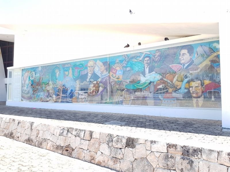
The mural begins at the top left of the viewer, with a version of the map of the Yucatan Peninsula that clearly illustrates the surface of Quintana Roo and contains the image of a flamingo. Below this, an enigmatic sculpture of Chac Mool, from whose container on his belly, rise bubbles that are soon detached, indicating some of them to be the main cities of the State: Cancún, Chetumal, Playa del Carmen, Felipe Carrillo Puerto, Tulúm, Alfredo V. Bonfil and Isla Mujeres. The Chac Mool also holds between its legs a small stela that represents the number zero, that is to say, that in a philosophical sense is the beginning of the entire origin of the Mayan civilization.
On the right side, there is a Nacom (Mayan chieftain) holding another seal, which means the number one. Other seals are also present, for example, one mounted on the horns of the moon, number two in Mayan numerology and finally number four, which points to hurricanes leading to a full moon. This recalls the influence of the moon on the cultural, meteorological, and cosmogonic life of the Maya. There is a tree that represents the ebony or the huanacaxtle and that its roots are confused with the staircase of a pyramid, so as to evoke the archaeological zones, patrimony of not only the State or of the nation, but of all of humanity. Quintana Roo has important areas in which the water has no outlet to the sea, so under the branches of the tree a cenote is discovered. Next to the cenote is a crocodile that represents one of the most important cenotes in the area, known as the Golden Crocodile. Below that we find the figures of Gónzalo Guerrero with his three children and his wife with a babe in arms to illustrate the beginning of mestizaje, in addition to the first naturalization of an Iberian in Mesoamerica, which together with Gerónimo de Aguilar generated a legend before the arrival of Hernán Cortés. Upwards from the crocodile, a snail and a type of coral that abounds in the seas of the Yucatan Peninsula appear. Above the coral a stream of water appears illustrating the
presence of multiple lagoons or swamps. On the lower part, a scene is shown of the shooting of the rebellious Mayas, symbolizing those that participated in the Caste War. Jacinto Pat and Cecilio Chi are shown, who together with Manuel Antonio Ay and some other local heroes in different periods of history, ranging from the Conquest until the first post-Revolutionary decades, were tortured, imprisoned or murdered.
Above their execution, there is a morphological symbol of the surface of the Municipality of Benito Juárez, Cancún and of the Island of Cozumel.
Moving in an updwards direction are the busts of Andrés Quintana Roo, as well as that of Leona Vicario. Below these images, a Hawksbill turtle heads towards the state seal, over a partial view of the fort of San Felipe Bacalar. This fort is related to its prison, where prisoners were sent from the end of the colonial period up to the Porfiriato. Political prisoners or rebels were sent there and this dramatic passage of national and local history is illustrated with a prisoner in a cage.
On the cage, a wooden house has also been placed, since at the beginning of the 20th century most of the houses of Chetumal were of made that material, similar to those of Belize.
The cabin is also shown below a flood wave, a product of tropical storms. Two species of animals are distinguished, that of a variety of bats such as the shoemaker, the ciricotero, the vampire, the guano and the fish bat, which goes after the small red snapper that lives in this region. Even the fish is a part of some local legends. The other species is the manatee, which is in danger of extinction.
Next to the manatee, a spider monkey safeguards itself next to the shape of a "T", as a reminder of the intelligence that these primates had to protect themselves from cyclones.
The monkey is pulling on the lapel of Francisco May Pech, who directed the purchase and sale of chicle production.
At the foot of the tree, there are a series of fruits such as peanuts, watermelon, melon, tomato, chili, as well as all the main vegetables that are harvested annually.
Towards the left there is a boquinete fish, which is shown suspended to highlight the importance of fishing.
On the right side of the chicozapote or chewing gum tree, we locate the face of Engineer Aarón Merino Fernández, as in his administration he left important infrastructure works, such as roads and urbanization after Hurricane Janet, without leaving out his campaign against malaria which is represented with the image of the mosquito, the transmitter of this disease.
The mural includes a beach detail with a thatched hut and a beach chair.
A cow is also observed, to illustrate the presence of livestock in Quintana Roo. Behind the cow, a sugar mill and a furniture factory are included, which allude to the industrial concerns of the state.
Finally, in the lower right corner, we can distinguish the bust of Javier Rojo Gómez, who provided many works of social benefit, such as the Normal Teaching Center in Bacalar, the construction of the Chetumal-Escárcega highway, the paving of the route from Puerto Juárez to Playa del Carmen and from Felipe Carrillo Puerto to Tulúm, all of which contributed to increase the domestic economy and the tourist industry in the State.
Artist: Julio Carrasco Bretón
Topics. This historical marker is listed in these topic lists: Colonial Era • Industry & Commerce • Native Americans • Settlements & Settlers.
Location. 18° 29.574′ N, 88° 17.577′ W. Marker is in Chetumal, Quintana Roo, in Othón P. Blanco. Marker is on Esmeralda just west of Avenida Reforma, on the left when traveling west. Touch for map. Marker is in this post office area: Chetumal QR 77000, Mexico. Touch for directions.
Other nearby markers. At least 8 other markers are within walking distance of this marker. Chetumal (about 180 meters away, measured in a direct line); Chetumal - Where Mexico Begins (about 240 meters away); The Force of Hurricane Janet (approx. 0.3 kilometers away); Casa de la Crónica (approx. 0.3 kilometers away); Anglo-Caribbean Style Residence (approx. 0.4 kilometers away); Avenida 5 de Mayo No. 23 (approx. 0.4 kilometers away); Avenida 5 de Mayo No. 29 (approx. 0.4 kilometers away); Theater of the City and the Constitution of Quintana Roo (approx. 0.4 kilometers away). Touch for a list and map of all markers in Chetumal.
Credits. This page was last revised on May 19, 2019. It was originally submitted on May 19, 2019, by J. Makali Bruton of Accra, Ghana. This page has been viewed 118 times since then and 7 times this year. Photos: 1, 2, 3, 4, 5, 6. submitted on May 19, 2019, by J. Makali Bruton of Accra, Ghana.
