The Tidal Basin in Southwest Washington in Washington, District of Columbia — The American Northeast (Mid-Atlantic)
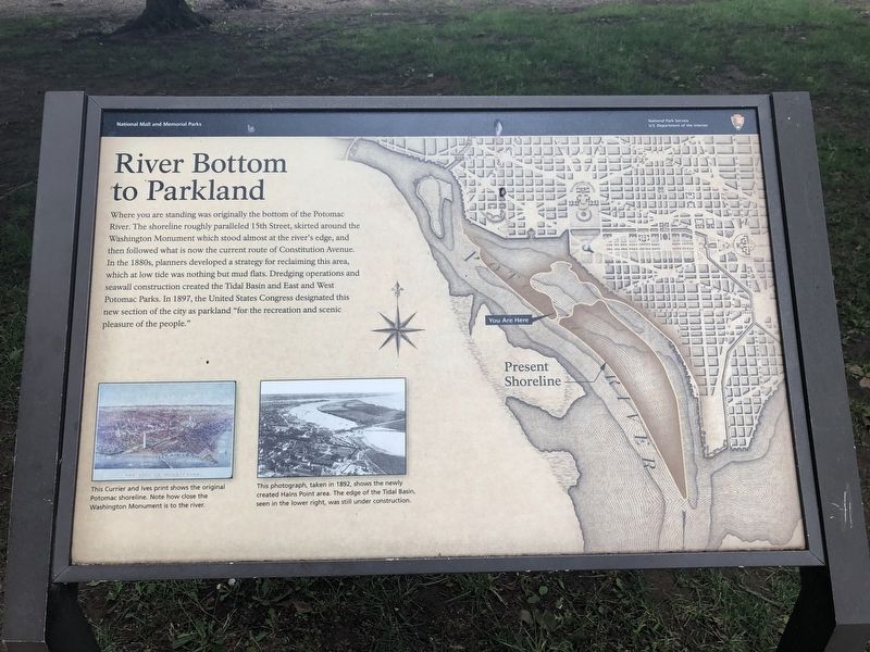
River Bottom to Parkland
National Mall and Memorial Parks
— National Park Service, U.S. Department of the Interior —
Erected by National Park Service, U.S. Department of the Interior.
Topics. This historical marker is listed in these topic lists: Parks & Recreational Areas • Roads & Vehicles • Waterways & Vessels. A significant historical year for this entry is 1897.
Location. 38° 52.863′ N, 77° 2.446′ W. Marker is in Southwest Washington in Washington, District of Columbia. It is in The Tidal Basin. Marker can be reached from Ohio Drive Southwest west of East Basin Drive Southwest, on the right when traveling north. Touch for map. Marker is at or near this postal address: 1420 Ohio Drive Southwest, Washington DC 20418, United States of America. Touch for directions.
Other nearby markers. At least 8 other markers are within walking distance of this marker . Yoshino (within shouting distance of this marker); The Gift of Friendship (about 500 feet away, measured in a direct line); Forgotten Founder (about 500 feet away); George Mason (about 500 feet away); The United Nations (about 700 feet away); Air Mail (about 800 feet away); "He Died in Harness" (approx. 0.2 miles away); Wartime President (approx. 0.2 miles away). Touch for a list and map of all markers in Southwest Washington.
More about this marker.
[Captions:]
This Currier and Ives print shows the original Potomac shoreline. Note how close the Washington Monument is to the river.
This photograph, taken in 1892, shows the newly created Hains Point area. The edge of the Tidal Basin, seen in the lower right, was still under construction.
Credits. This page was last revised on January 30, 2023. It was originally submitted on June 18, 2019, by Devry Becker Jones of Washington, District of Columbia. This page has been viewed 205 times since then and 26 times this year. Photos: 1, 2. submitted on June 18, 2019, by Devry Becker Jones of Washington, District of Columbia.

