Mianach Hero agus Urláir Chóireála
⎯⎯⎯
Hero Mine and Dressing Floors
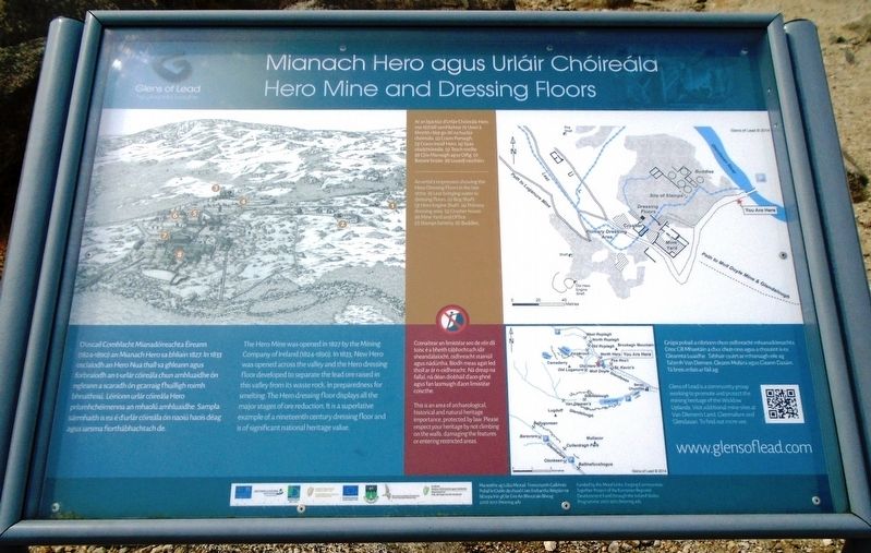

Ar an bpictiúr d'Urláir Chóireála Hero sna 1870idí samhlaítear (1) Uisce á bhreith i léat go dtí na hurláir chóireála. (2) Crann Portaigh. (3) Crann Ineall Hero. (4) Spás céadchóireála. (5) Teach meilte. (6) Clós Mianaigh agus Oifig. (7) Bátaire brúite. (8) Losaidí níocháin.
Cosnaítear an limistéar seo de réir dlí toisc é a bheith tábhachtach idir sheandálaíocht, oidhreacht stairiúil agus nádúrtha. Bíodh meas agat led thoil ar án n-oidhreacht. Ná dreap na fallaí, ná déan díobháil d'aon ghné agus fan lasmuigh d'aon limistéar coiscthe.
Grúpa pobail a oibríonn chun oidhreacht mhianadóireachta Cnoc Cill Mhantáin a chur chun cinn agus a chosaint is ea Gleannta Luaidhe. Tabhair cuairt ar mhianaigh eile ag Talamh
An artist's impression showing the Hero Dressing Floors in the late 1870s. (1) Leat bringing water to dressing floors. (2) Bog Shaft. (3) Hero Engine Shaft. (4) Primary dressing area. (5) Crusher house. (6) Mine Yard and Office. (7) Stamps battery. (8) Buddles.
This is an area of archaeological, historical and natural heritage importance, protected by law. Please respect your heritage by not climbing on the walls, damaging the features or entering restricted areas.
Glens of Lead is a community group working to promote and protect the mining heritage of the Wicklow Uplands. Visit additional mine sites at Van Diemen's Land, Glenmalure and Glendasan.
this page online
Erected by Glens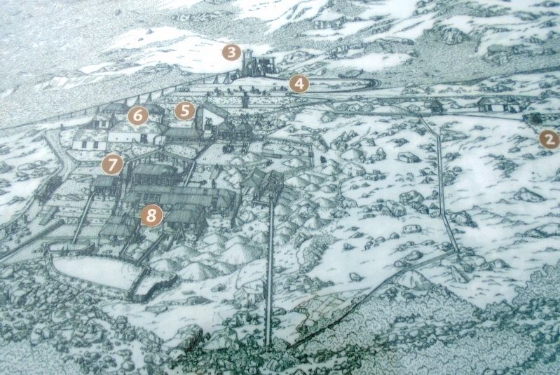
Topics. This historical marker is listed in these topic lists: Environment • Industry & Commerce • Man-Made Features. A significant historical year for this entry is 1827.
Location. 53° 1.39′ N, 6° 21.76′ W. Marker is near Glendasan, Leinster, in County Wicklow. It is on Wicklow Gap Road (Leinster Route R756), on the left when traveling west. Touch for map. Touch for directions.
Regionally, this marker is in the Ancient East. Globally, it is on the Atlantic Ocean, in the North Atlantic Region, in Europe, on the Island of Ireland, on the Celtic Fringe, in the European Union, in Atlantic Europe, on one of the British Isles, in the Western World, and in the Anglosphere.
Other nearby markers. At least 8 other markers are within 21 kilometers of this marker, measured as the crow flies: An Cloigtheach / The Round Tower (approx. 2.7 kilometers away); 'Teach na Sagart' / The 'Priest's House' (approx. 2.8 kilometers away); An Ardeaglais / The Cathedral (approx. 2.8 kilometers away); St. Kevin's Way
Also see . . .
1. History of the Glendalough and Glendasan Mines (Luganure). (Submitted on June 27, 2019, by William Fischer, Jr. of Reynoldsburg, Ohio.)
2. Mining in Wicklow Mountains National Park. (Submitted on June 28, 2019, by William Fischer, Jr. of Reynoldsburg, Ohio.)
Credits. This page was last revised on August 19, 2020. It was originally submitted on June 27, 2019, by William Fischer, Jr. of Reynoldsburg, Ohio. This page has been viewed 220 times since then and 13 times this year. Photos: 1, 2, 3, 4, 5, 6. submitted on June 28, 2019, by William Fischer, Jr. of Reynoldsburg, Ohio.
