Nautical Artefacts at Kinsale Museum
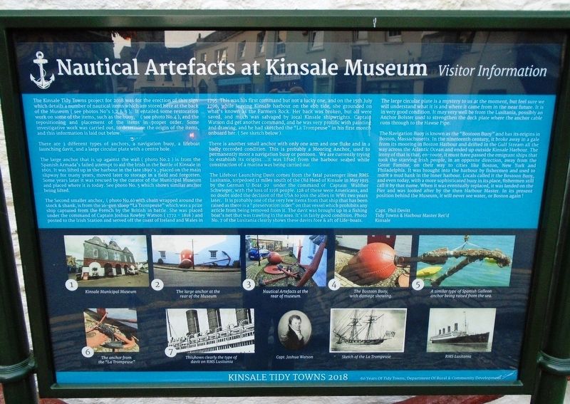
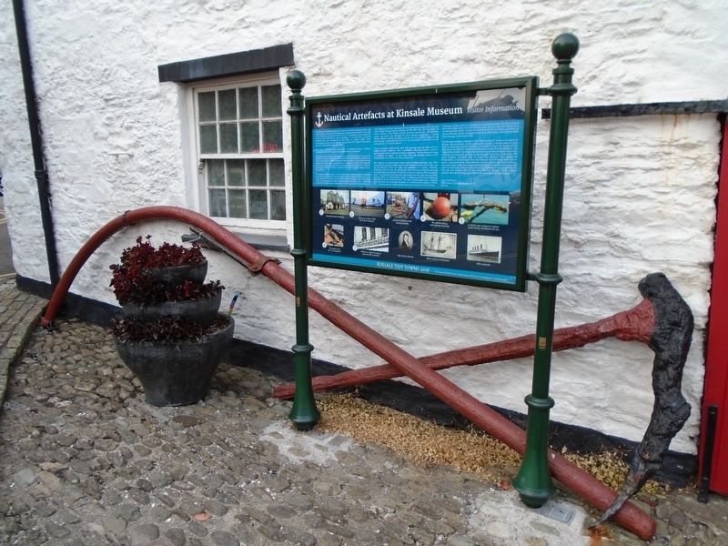
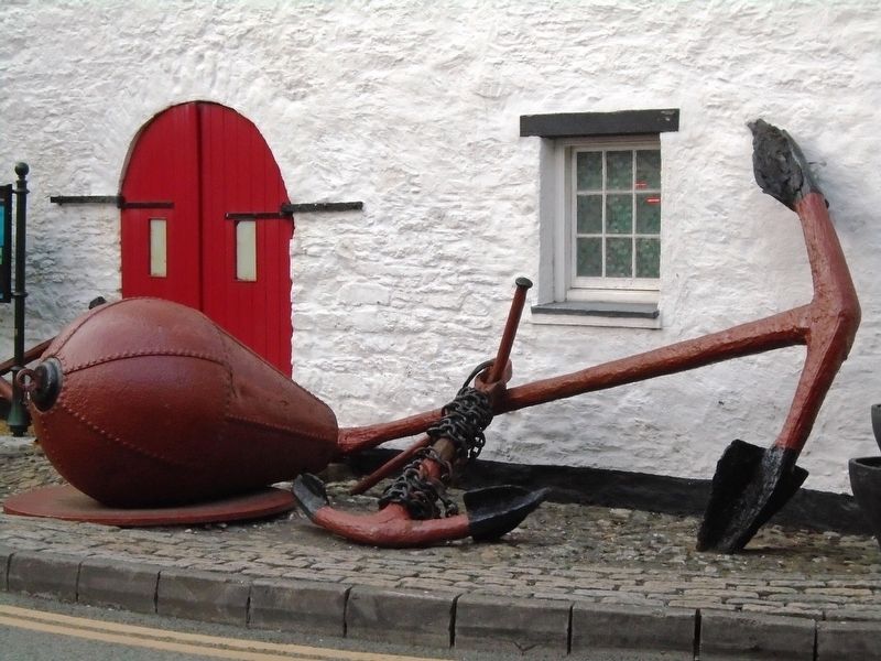
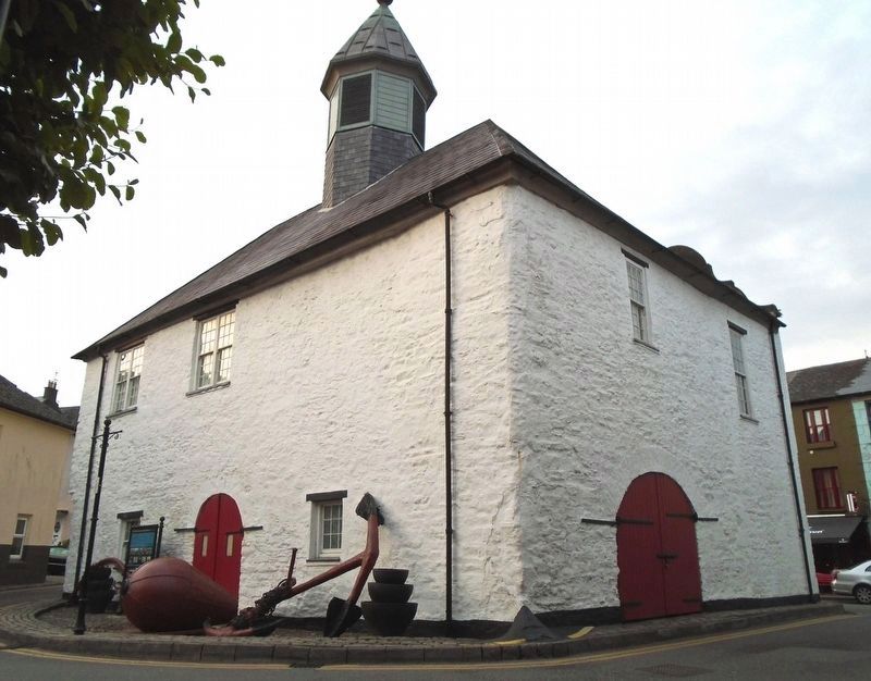
The Kinsale Tidy Towns project for 2018 was for the erection of this sign which details a number of nautical items which are stored here at the back of the Museum (see photos No's 1,2 & 3). It entailed some restoration work on some of the items, such as the buoy, (see photo No.4), and the repositioning and placement of the items in proper order. Some investigative work was carried out, to determine the origin of the items, and this information is laid out below.
There are 3 different types of anchors, a navigation buoy, a lifeboat launching davit, and a large circular plate with a centre hole.
The large anchor that is up against the wall (photo No.2) is from the Spanish Armada's failed attempt to aid the Irish in the Battle of Kinsale in 1601. It was lifted up in the harbour in the late 1890's, placed on the main slipway for many years, moved later to storage in a field and forgotten. Some years later it was rescued by the curator of the Municipal Museum and placed where it is today. See photo No. 5 which shows similar anchor being lifted.
The Second small anchor, (photo No.6) with chain wrapped around the stock & shank, is from the 16-gun sloop "La Trompeuse" which was a prize ship captured from the French by the British in battle. She was placed under the command of Captain Joshua Rowley Watson (1772 - 1818) and posted
to the Irish Station and served off the coast of Ireland and Wales in 1795. This was his first command but not a lucky one, and on the 15th.July 1796, while leaving Kinsale harbour on the ebb tide, she grounded on what's known as the Farmers Rock. Her back was broken, but all were saved, and much was salvaged by local Kinsale shipwrights. Captain Watson did get another command, and he was very prolific with painting and drawing, and he had sketched the "La Trompeuse" in his first month onboard her. (See sketch below).There is another small anchor with only one arm and one fluke and in a badly corroded condition. This is probably a Mooring Anchor, used to permanently moor a navigation buoy or pontoon. We are currently trying to establish its origins....it was lifted from the harbour seabed while construction of a marina was being carried out.
The Lifeboat Launching Davit comes from the fatal passenger liner RMS Lusitania, torpedoed 11 miles south of the Old Head of Kinsale in May 1915 by the German U Boat 20 under the command of Captain Walther Schwieger, with the loss of 1198 people, 128 of these were Americans, and no doubt aided the decision of the USA to join the allies in WW1 two years later. It is probably one of the very few items from that ship that has been raised as there is a "preservation order" on that vessel which prohibits any article from being removed from
The large circular plate is a mystery to us at the moment, but feel sure we will understand what it is and where it came from in the near future. It is in very good condition. It may very well be from the Lusitania, possibly an Anchor Bolster used to strengthen the deck plate where the anchor cable runs through to the Hawse Pipe.
The Navigation Buoy is known as the "Bostoon Buoy" and has its origin in Boston, Massachusetts. In the nineteenth century, it broke away in a gale from its mooring in Boston Harbour and drifted in the Gulf Stream all the way across the Atlantic Ocean and ended up outside Kinsale Harbour. The irony of that is that, en-route, it must have passed the emigrant ships that took the starving Irish people, in an opposite direction, away from the Great Famine, on their way to cities like Boston, New York and Philadelphia. It was brought into the harbour by fishermen and used to mark a mud bank in the inner harbour. Locals called it the Bostoon Buoy, and even today, with a more sophisticated buoy in its place, fishermen still call it by that name. When it was eventually replaced, it was landed on the Pier and was looked after by the then Harbour Master. In its
present position behind the Museum, it will never see water, or Boston again!
Capt. Phil Devitt
Tidy Towns & Harbour Master Ret'd
Kinsale
[Photo captions]
1. Kinsale Municipal Museum
2. The large anchor at the rear of the Museum
3. Nautical Artefacts at the rear of museum.
4. The Bostoon Buoy, with damage showing.
5. A similar type of Spanish Galleon anchor being raised from the sea.
6. The anchor from the "La Trompeuse"
7. This shows clearly the type of davit on RMS Lusitania
Capt. Joshua Watson
Sketch of the La Trompeuse
RMS Lusitania
Erected 2018 by Kinsale Tidy Towns.
Topics. This historical marker is listed in these topic lists: Disasters • Man-Made Features • Wars, Non-US • Waterways & Vessels. A significant historical year for this entry is 2018.
Location. 51° 42.375′ N, 8° 31.464′ W. Marker is in Kinsale, Munster, in County Cork. Marker is on Market Lane, on the left when traveling east. Touch for map. Marker is at or near this postal address: Market Square, Kinsale, Munster P17 D962, Ireland. Touch for directions.
Other nearby markers. At least 8 other markers are within walking distance of this marker. Múseum / Museum (within shouting distance of this marker); Peter Barry (within shouting distance of this marker); The Town Pound (within
Related marker. Click here for another marker that is related to this marker.
Also see . . .
1. The Kinsale Regional Museum. (Submitted on July 24, 2019, by William Fischer, Jr. of Scranton, Pennsylvania.)
2. History of Kinsale. (Submitted on July 24, 2019, by William Fischer, Jr. of Scranton, Pennsylvania.)
3. Lost Liners: Lusitania. (Submitted on July 24, 2019, by William Fischer, Jr. of Scranton, Pennsylvania.)
4. RMS Lusitania. (Submitted on July 24, 2019, by William Fischer, Jr. of Scranton, Pennsylvania.)
Credits. This page was last revised on September 15, 2019. It was originally submitted on July 24, 2019, by William Fischer, Jr. of Scranton, Pennsylvania. This page has been viewed 185 times since then and 15 times this year. Photos: 1, 2, 3, 4. submitted on July 24, 2019, by William Fischer, Jr. of Scranton, Pennsylvania.


