Sandston in Henrico County, Virginia — The American South (Mid-Atlantic)
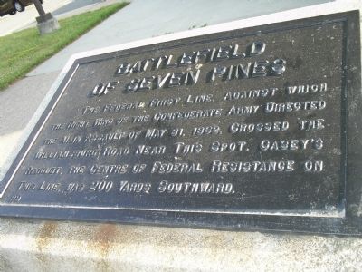
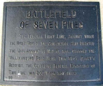
Battlefield of Seven Pines
Erected by Battlefield Markers Association. (Marker Number 39.)
Topics and series. This historical marker is listed in these topic lists: Notable Events • Notable Places • War, US Civil. In addition, it is included in the Freeman Markers (Richmond Battlefields) series list. A significant historical date for this entry is May 31, 1864.
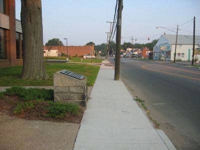
Location. 37° 31.358′ N, 77° 18.738′ W. Marker is in Sandston, Virginia, in Henrico County. Marker is on East Williamsburg Road (U.S. 60) east of Naglee Avenue, on the right when traveling east. Marker is located in front of the Sandston Library. Touch for map. Marker is at or near this postal address: 23 E Williamsburg Rd, Sandston VA 23150, United States of America. Touch for directions.
Other nearby markers. At least 8 other markers are within walking distance of this marker. Seven Pines (a few steps from this marker); Site of the First Public Library in Henrico County (a few steps from this marker); a different marker also named Battlefield of Seven Pines (about 600 feet away, measured in a direct line); McClellan’s First Line (approx. 0.2 miles away); a different marker also named Battlefield of Seven Pines (approx. 0.2 miles away); Sandston (approx. ¼ mile away); a different marker also named Battlefield of Seven Pines (approx. 0.4 miles away); McClellan’s Picket Line (approx. half a mile away). Touch for a list and map of all markers in Sandston.
Also see . . .
1. Seven Pines. CWSAC Battle Summaries website. (Submitted on August 22, 2008, by Bill Coughlin of Woodland Park, New Jersey.)
2. The Battle of Seven Pines. Detailed information of the Seven Pines battle. (Submitted on August 22, 2008, by Bill Coughlin of Woodland Park, New Jersey.)
3. Virtual Tour by Markers of the Battle of Seven Pines. This is one of several markers describing the actions of May 31 - June 1, 1862. (Submitted on May 1, 2009, by Bernard Fisher of Richmond, Virginia.)
Additional keywords. Freeman Markers, Richmond Battlefield Parks Corporation, Douglas Southall Freeman
Credits. This page was last revised on February 18, 2023. It was originally submitted on August 22, 2008, by Bill Coughlin of Woodland Park, New Jersey. This page has been viewed 2,853 times since then and 63 times this year. Last updated on December 8, 2008, by Bernard Fisher of Richmond, Virginia. Photos: 1. submitted on August 22, 2008, by Bill Coughlin of Woodland Park, New Jersey. 2, 3. submitted on December 8, 2008, by Bernard Fisher of Richmond, Virginia. • Craig Swain was the editor who published this page.


