Williston in Williams County, North Dakota — The American Midwest (Upper Plains)
Plants of the Plains
Missouri-Yellowstone Confluence Interpretive Center

Photographed By Barry Swackhamer, August 16, 2019
1. Plants of the Plains Marker
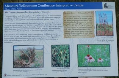
Captions: (bottom left) Big sagebrush was important to the native population for its wound-healing properties.; (bottom center) Buffalograss is short, drought-resistant prairie turfgrass.; (bottom right) Coneflowers are still sought by people for their medicinal properties and are common ingredients in over-the-counter natural remedies.; (top right) Big bluestem grass grows from there to 10 feet tall and was an important part of the American bison's diet.
This area held large herds of bison, elk, and deer, which had grazed on grasses and shrubs for millennia. Chief among the native grasses were big bluestem, buffalo grass, and needle-and-tread grass. Big sagebrush was a common shrub on the semi-arid plains.
Prairies provided native peoples with plants, used for food and medicine. Paste or tea made from purple coneflower root was used by many Northern Plains tribes to treat their coughs, sore throats, and headaches. They called the plant "elk root" because they learned of its effectiveness when they saw sick or wounded elk eat the plant. When Meriwether Lewis sent seeds to President Jefferson, he indicated it was used for snakebites.
Indian bread root, also called prairie turnip, was an important food for native peoples because it can be eaten raw, boiled, dried, or pounded into flour. It was also sought after by grizzly bears, once common among the wooded stream bottoms. Indian breadroot seeds collected by Lewis are preserved today by the Academy of Natural Sciences in Philadelphia.
This root (beadroot) forms a considerable article of food with the Indians of the Missouri, who for this purpose prepare them in several ways. they are esteemed good at all seasons of the year, but are best from the middle of July to the latter end to Autumn when they are sought and gathered by the provident part of the natives for their winter store. when collected they are striped of their rhind and strung on small throngs or chords and exposed to the sun or placed in the smoke of their fires to dry; when well dryed they will keep for several years.... -- Meriwether Lewis, Wednesday May 8th 1805
Erected by State Historical Society of North Dakota.
Topics and series. This historical marker is listed in these topic lists: Exploration • Native Americans • Natural Features. In addition, it is included in the Former U.S. Presidents: #03 Thomas Jefferson, and the Lewis & Clark Expedition series lists. A significant historical date for this entry is May 8, 1805.
Location. 47° 58.941′ N, 103° 59.702′ W. Marker is in Williston, North Dakota, in Williams County. Marker can be reached from 39th Lane Northwest near 153rd Avenue Northwest. Touch for map. Marker is in this post office area: Williston ND 58801, United States of America. Touch for directions.
Other nearby markers. At least 8 other markers are within walking distance of this marker. Water Ways and Mean (a few steps from this marker); Lesser Known Forts at the Confluence (approx. 0.3 miles away); Mosquitoes (approx. 0.3 miles away); Parade Ground (approx. 0.4 miles away); Fort Buford State Historic Site (approx. 0.4 miles away); Fort Buford Historic Site (approx. 0.4 miles away); Missouri-Yellowstone Confluence (approx. 0.4 miles away); Telegraph Office (approx. 0.4 miles away). Touch for a list and map of all markers in Williston.
More about this marker. This marker is on the grounds of Fort Buford State Historic Site.
Credits. This page was last revised on December 3, 2019. It was originally submitted on December 3, 2019, by Barry Swackhamer of Brentwood, California. This page has been viewed 177 times since then and 14 times this year. Photos: 1, 2. submitted on December 3, 2019, by Barry Swackhamer of Brentwood, California.
