
Bayside in Saint Andrews, New Brunswick — The Atlantic Provinces (North America)
Where Two Worlds Met
⎯⎯⎯
Rencontre de deux mondes
Photographed by Cosmos Mariner, July 13, 2019
1. Where Two Worlds Met /
Rencontre de deux mondes Marker
Rencontre de deux mondes Marker

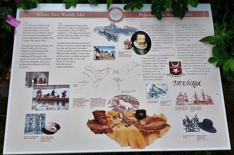
The Micmac, Maliseet, and Passamaquoddy hunters and traders provided a commercial lifeline for Sieur de Monts' colony. Their first-hand knowledge of the territory allowed these entrepreneurs to control the supply of furs.
Through their earlier dealings with French traders, the Micmac, Maliseet, and Passamaquoddy were very familiar with the usefulness of European trade goods. To continue this exchange of furs for European items, they formed trade alliances with Sieur de Monts.
The anticipation of huge profits from the fur trade motivated people to participate in Sieur de Monts' expedition. In Europe, the popularity of beaver felt hats made beaver pelts a highly valued commodity.
In 1603, Sieur de Monts received from Henry IV a ten-year exclusive right to the fur trade, and the title of Lieutenant-General of Acadie, a territory between the 40th and 46th parallels. In return, Sieur de Monts had to undertake and pay the costs of colonization. In this way, Henry IV was able to realize his vision of overseas colonization.
Lies chasseurs et les négociants des ri peuples micmacs, malécites et
this page online
Les Micmacs, les Malécites et les Passamaquoddy, qui ont déjà commercé avec les Français, connaissent donc l'utilité des produits européens. Pour continuer à troquer des fourrures contre ces produits, ils concluent des alliances commerciales avec le sieur de Monts.
Les membres de l'expédition du sieur de Monts sont motivés par l'espoir de tirer d'énormes profits de la traite des fourrures. En Europe, la mode du chapeau de castor fait de la peau de castor un objet de commerce de grande valeur.
En 1603, le sieur de Monts se voit accorder par Henri IV un droit exclusif de dix ans sur la traite des fourrures, et le titre de lieutenant général de l'Acadie, territoire s'étendant du 40e au 46e parallèle. Le sieur de Monts doit, en échange, entreprendre et payer les coûts de la colonisation du territoire. C'est ainsi que Henri IV concrétise sa vision de la te colonisation outre-mer.
Erected by Parks Canada / Parcs Canada.
Topics and series.

Courtesy N.S. Ed. Media Services/Micmac Assoc. for Cultural Studies
2. Marker detail: Micmac, Maliseet, and Passamaquoddy
The Micmac, Maliseet, and Passamaquoddy, living in a common northern environment, shared many cultural similarities, yet their histories were different.
Les Micmacs, Malécites et Passamaquoddy, vivant tous dans un même milieu septentrional, ont de nombreux points communs sur le plan cuturel, bien que leur histoire soit différente.
Les Micmacs, Malécites et Passamaquoddy, vivant tous dans un même milieu septentrional, ont de nombreux points communs sur le plan cuturel, bien que leur histoire soit différente.
Location. 45° 8.064′ N, 67° 6.768′ W. Marker is in Bayside, New Brunswick, in Saint Andrews. It can be reached from New Brunswick Highway 127 (New Brunswick Route 127) 9 kilometers south of Route 1, on the right when traveling south. Marker is located at the Saint Croix Island National Historic Site, along the interpretive trail. Touch for map. Marker is at or near this postal address: 3509 New Brunswick Highway 127, Bayside NB E5B 2V2, Canada. Touch for directions.

Regionally, this marker is in Charlotte County and the Fundy Isles. It is also in the Maritimes and in Atlantic Canada. Globally, it is in the North Atlantic Region, North America, the Western Hemisphere, the Western World, and the Anglosphere. Historically, it finds itself in what was once a British colony, the Viceroyalty of New France, and Acadia.
Other nearby markers. At least

Courtesy British Library, C74G.5
3. Marker detail: Aboriginal peoples selling in an open market
Detail from: Aboriginal peoples selling in an open market.
Détail de l’image: Peuples autochtones vendant leurs produits au marché.
Détail de l’image: Peuples autochtones vendant leurs produits au marché.
Related markers. Click here for a list of markers that are related to this marker. Saint Croix Island International Historic Site / Île Sainte-Croix Lieu historique international
Also see . . . Saint Croix Island International Historic Site: Where Two Worlds Meet. (Submitted on January 18, 2020, by Cosmos Mariner of Cape Canaveral, Florida.)

Photographed by Anonymous 17th-century French School, Museum of Grenoble
4. Marker detail: Henry IV, King of France /
Henri IV, Roi de France
Henri IV, Roi de France

Courtesy British Library, G6633(6)
5. Marker detail: Fort Caroline
The French building Fort Caroline, Florida, 1564.
Les Français construisent le fort Caroline en Floride, 1564.
Les Français construisent le fort Caroline en Floride, 1564.

6. Marker detail: The French had been fishing cod and trading for furs for over a century before 1604
En 1604, les Français pêchent la morue et font la traite des fourrures depuis déjà plus d'un siècle.

Courtesy Amman, J., Book of Trades, 1971
7. Marker text: European hatters making felt hats
Chapeliers européens confectionnant des chapeaux de feutre

Photographed by Cosmos Mariner, July 13, 2019
8. Where Two Worlds Met Marker • wide view
(leftmost of 3 related markers at this location)
(leftmost of 3 related markers at this location)
Credits. This page was last revised on June 1, 2021. It was originally submitted on January 15, 2020, by Cosmos Mariner of Cape Canaveral, Florida. This page has been viewed 230 times since then and 15 times this year. Photos: 1. submitted on January 15, 2020, by Cosmos Mariner of Cape Canaveral, Florida. 2, 3, 4, 5, 6, 7, 8. submitted on January 17, 2020, by Cosmos Mariner of Cape Canaveral, Florida.
