Salamá, Baja Verapaz, Guatemala — Central America
Salamá, Baja Verapaz
Inscription.
Nuestro estandarte · Nuestros colores
El nombre original de esta región fue Tucurutan a veces escrito como Tezulutlan o Tezulutlan, según afirma el diccionario Geográfico Nacional, Tierra de Hombres y mujeres valientes.
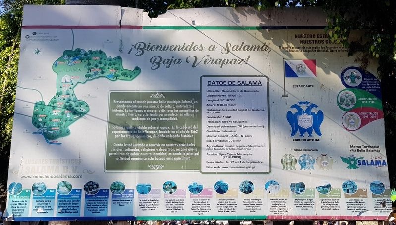
Presentamos al mundo nuestro bello municipio Salamá, en donde encontrará una mezcla de cultura, naturaleza e historia. Le invitamos a conocer y disfrutar las maravillas de nuestra tierra, caracterizada por prevalecer en ella un ambiente de paz y tranquilidad. Salamá significa “Tabla sobre el agua”. Es la cabecera del departamento de Baja Verapaz, fundado en el año de 1562 por los frailes dominicos, dejando un legado histórico. Queda usted invitado a convivir en nuestras actividades sociales, culturales, religiosos y deportivos, razones que le permitirán descubrir nuestra identidad, en donde la principal actividad económica esta basada en la agricultura.
Datos de Salamá
Ubicación: Region Norte de Guatemala.
Latitud Norte: 15°06'12
Longitud: 90°16'00"
Altura: 940.80 msnm
Distancia: de la ciudad capital de Guatemala 150km
Fundación: 1,562
Población: 60,174 habitantes
Densidad poblacional: 70 (personas km)
Gentilicio: Salamateco
Idioma: Español - Achi - Q'eqchi
Ext. Territorial: 776 km2
Agricultura: tomate, pepino, chile pimiento, ejote francés, brócoli, maíz, frijol.
Alcalde: Byron Tejeda Marroquin (2016-2020)
Feria titular: del 17 a 21 de Septiembre
Sitio web: www.munisalama.gob.gt
Estandarte · Escudo Actual · Otras versiones
Dibujo del ave bicéfala que calco Fray Bartolome de una estela de Piedra en Salamá
Administración 1994-1998
Administración 2002-2006
Marca Territorial “Mi Bella Salamá”
Lugares Turísticos Salamá B.V.
www.conociendosalama.com
01 Salto de Chilascó – Hermosa caída de agua de 130 mts. De altura de bosques exuberantes y biodiversidad admirable.
02 Biotopo de Quetzal – Santuario para la conservación y protección del ave símbolo de Guatemala el quetzal.
03 Reserva Ecológico Saq Ha’ – Ubicada en el corridor Biológico del bosque nuboso es una reserva de singular belleza, con su biodiversidad.
04 El Tempisque – Comunidad ubicada en los … del río Salamá en donde prevalence su cultura maya ancestral, dedicada a la producción agrícola tradicional.
05 Microcuenca Río Cachil – Fuente de abastacimiento de agua para el Municipio de Salamá.
06 Iglesia Parroquial San Mateo Apóstol – Su fachada es de estilo barroco fundada en el siglo XVI, dedicada al Santo Patrón del pueblo, el evangelista y apóstol San Mateo.
07 Iglesia San Ignacio – Fue construido en la época colonial, dedicada al milagrosa Señor Crucificado de Ostúa, su celebración se realiza el 14 de Enero de cada año.
08 Iglesia Las Anonas – Ubicada en la Sierra de Chuscús, rodeada de bosques de pino con vista paisajística hacia el valle Salamá. Se distingue por su romerío al Señor de la Agonia.
09 Peña de Lego – Es famosa por su vista paisajista hacia el área su del municipio, se caracteriza por ser un lugar rocoso y de clima frio, rodeado de bosque de roble y encino.
10 Poza Los Cajones – Caídas y pozos de agua formadas entre las rocas a través del tiempo, propiciando un lugar para la recreación y convivencia familiar.
11 Trapiche de Agua – Comunidad indígena en donde fabrica ollas, comales y jarros de cascarón, con origen ancestral, su agricultura la constituye el maiz, frijol y caña de azucar.
12 Aguas Termales – Pequeñas pozos de aguas termales que nacen entre las rocas, convirtiendo un lugar atractivo, de beneficio y recreación.
13 Iglesia Llano Grande – Lugar asentada en un valle de gente laboriosa, dedicados a la agricultura y ganaderia, cuenta con una iglesia católica moderna.
14 Chivac – Lugar ubicado a las cercanías del Río Motagua, su clima es cálido y en su agricultura prevalecen las siembras de maicillo y rosa de Jamaica.
15 Río Motagua – La playa del Río Motagua permite la recreación familiar en un ambiente cálido, además es un valioso recurso para la extracción de minerales.
7956-3100
[email protected]
www.munisalama.gob.gt
Welcome to Salamá, Baja Verapaz!
Our banner · Our colors
The original name of this region was Tucurutan, also written as Tezulutlan, according to the National Geographic Dictionary. It meant “Land of brave men and women.”
We present to the world our beautiful municipality Salamá, where you will find a mixture of culture, nature and history. We invite you to know and enjoy the wonders of our land, characterized by an atmosphere of peace and tranquility. Salamá means "Wood on the water." It is the capital of the department of Baja Verapaz, founded in 1562 by Dominican friars, leaving a historical legacy. You are invited to participate in our social, cultural, religious and sports activities, allowing you to discover our identity, where the main economic activity is based on agriculture.
Important facts about Salamá:
Location: Northern Region of Guatemala.
Latitude: 15° 06' 12”
Longitude:
90° 16' 00"
Height: 940.80 masl
Distance: from the capital city of Guatemala 150 km
Foundation: 1562
Population: 60,174 inhabitants
Population density: 70 persons per km2
Demonym: Salamateco
Languages: Spanish - Achi - Q'eqchi
Territorial extension: 776 km2
Agriculture: tomato, cucumber, pepper, French bean, broccoli, corn, beans.
Mayor: Byron Tejeda Marroquin (2016-2020)
Annual fair: September 17-21
Website: www.munisalama.gob.gt
Our Banner · Municipal Seal · Other versions
Drawing of the double-headed bird that Friar Bartolome traced on a stone in Salamá
Administration 1994-1998
Administration 2002-2006
Territorial Brand - “My Beautiful Salamá”
Tourist Locations in Salamá, Baja Verapaz
www.conociendosalama.com
01 Chilascó Waterfall – A beautiful waterfall, 130 meters high in lush forests and admirable biodiversity.
02 Quetzal Biological Reserve - Sanctuary for the conservation and protection of the Guatemalan national bird, the quetzal.
03 Saq Ha ’Ecological Reserve - Located in the biological corridor of the cloud forest, it is a reserve of unique beauty with its biodiversity.
04 El Tempisque - Community located along the Salamá River where its ancestral Mayan culture prevails, dedicated to traditional agricultural production.
05 Cachil River Microbasin - Water supply for the Municipality of Salamá.
06 San Mateo Apostle Parish Church - Its facade is of Baroque style founded in the 16th century, dedicated to the patron saint of the town, the evangelist and Apostle San Mateo.
07 San Ignacio Church - It was built in the colonial era, dedicated to the miraculous Crucified Christ of Ostúa, its celebration takes place on January 14 of each year.
08 Las Anonas Church - Located in the Sierra de Chuscús, surrounded by pine forests with a scenic view of the Salamá valley. It is distinguished by its pilgrimage to the Lord of Agony.
09 Peña de Lego - It is famous for its landscape and view towards the area of the municipality, it is characterized as a rocky place with cold weather, surrounded by an oak forest.
10 Poza Los Cajones – Waterfalls and natural springs have formed between the rocks over time, providing a place for recreation and family fun.
11 Water Mill (Trapiche) – An indigenous community where clay pots, plates and jugs are made with ancestral techniques. Its agriculture is corn, beans and sugar cane.
12 Hot Springs - Small hot springs that spring from the area’s rocks, making them an attractive place for recreation.
13 Llano Grande Church - A place set in a valley of industrious people, dedicated to agriculture and livestock, it has a modern Catholic church.
14 Chivac - A place located near the Motagua River, its climate is warm and its agriculture includes corn and sorrel tea.
15 Motagua River - The Motagua River beach allows family recreation in a warm environment, it is also a valuable resource for mineral extraction.
7956-3100
[email protected]
www.munisalama.gob.gt
Erected by Municipalidad de Salamá.
Topics. This historical marker is listed in these topic lists: Churches & Religion • Colonial Era • Industry & Commerce • Parks & Recreational Areas. A significant historical date for this entry is January 14, 1562.
Location. 15° 6.153′ N, 90° 19.123′ W. Marker is in Salamá, Baja Verapaz. Marker is at the intersection of 7a Calle and 6a Avenida, on the left when traveling south on 7a Calle. Touch for map. Marker is in this post office area: Salamá, Baja Verapaz 15001, Guatemala. Touch for directions.
Other nearby markers. At least 3 other markers are within 18 kilometers of this marker, measured as the crow flies. Miguel Angel Asturias (within shouting distance of this marker); José Mariano Mociño (approx. 16.4 kilometers away); Sebastián Castro García (approx. 17.3 kilometers away).
Credits. This page was last revised on February 19, 2020. It was originally submitted on February 15, 2020, by J. Makali Bruton of Accra, Ghana. This page has been viewed 664 times since then and 72 times this year. Photos: 1, 2, 3, 4, 5. submitted on February 15, 2020, by J. Makali Bruton of Accra, Ghana.


