Castle Rock in Cowlitz County, Washington — The American West (Northwest)
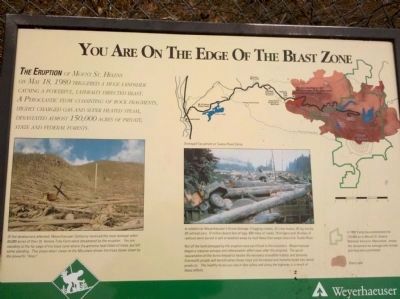
Mount St. Helens - Edge of the Blast Zone
The eruption of Mount St. Helens on May 18, 1980 triggered a huge landslide causing a powerful, laterally directed blast. A pyroclastic flow consisting of rock fragments, highly charged gas and super heated steam, devastated almost 150,000 acres of private, state and federal forests.
Side Bar:
In 1982 Congress established the 110,000 acre Mount St. Helens National Volcanic Monument. Inside the monument no salvage and no tree planting were permitted.
Erected by Wyerhaeuser.
Topics. This historical marker is listed in these topic lists: Disasters • Environment • Horticulture & Forestry. A significant historical date for this entry is May 18, 1980.
Location. 46° 19.776′ N, 122° 26.239′ W. Marker is in Castle Rock, Washington, in Cowlitz County. Marker is on Spirit Lake Highway (Washington Route 504), on the right when traveling east. This road is open seasonally, so check ahead. Touch for map. Marker is in this post office area: Castle Rock WA 98611, United States of America. Touch for directions.
Other nearby markers. At least 1 other marker is within 15 miles of this marker, measured as the crow flies. Mossyrock (approx. 14.4 miles away).

Photographed By Lora Mueller
2. Close-Up of Photo Displayed on Marker
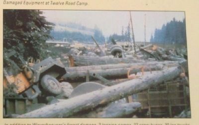
Damaged Equipment at Twelve Road Camp - In addition to Weyerhaeuser's forest damage, 3 logging camps, 22 crew buses, 30 log trucks, 39 railroad cars, 12 million board feet of logs, 650 miles of roads, 19 bridges and 16 miles of railroad were buried in ash or washed away by mud flows that swept down the Toutle River.
Not all the land damaged by the eruption was sacrificed to the mountain. Weyerhaeuser began a massive salvage and reforestation effort soon after the eruption. The quick rejuvenation of the forest helped to hasten the recovery of wildlife habitat and streams. Eventually people will benefit when these trees are harvested and manufactured into wood products. The healthy forest you see in this valley and along the highway is a result of those efforts.
Not all the land damaged by the eruption was sacrificed to the mountain. Weyerhaeuser began a massive salvage and reforestation effort soon after the eruption. The quick rejuvenation of the forest helped to hasten the recovery of wildlife habitat and streams. Eventually people will benefit when these trees are harvested and manufactured into wood products. The healthy forest you see in this valley and along the highway is a result of those efforts.

Photographed By Lora Mueller
3. Close-Up of Photo Displayed on Marker
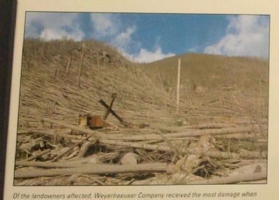
Of the landowners affected, Weyerhaeuser Company received the most damage when 68,000 acres of their St. Helens Tree Farm were devastated by the eruption. You are standing at the far edge of the blast zone where the extreme heat killed all the trees, but left some standing. This photo taken closer to the Mountain shows the trees blown down by the powerful "blast".
Credits. This page was last revised on March 3, 2020. It was originally submitted on December 19, 2011, by Lora Wilson of Paw Paw, West Virginia. This page has been viewed 1,330 times since then and 27 times this year. Last updated on March 2, 2020, by Lora Wilson of Paw Paw, West Virginia. Photos: 1, 2, 3, 4. submitted on December 19, 2011, by Lora Wilson of Paw Paw, West Virginia. • J. Makali Bruton was the editor who published this page.
Editor’s want-list for this marker. Wide area view of the marker and its surroundings. • Photos of the area showing effects of the eruption and forest restoration. • Can you help?

