Fort Washington in Prince George's County, Maryland — The American Northeast (Mid-Atlantic)
A Park with a Past
Oxon Cove Park
— National Park Service, U.S. Department of the Interior —
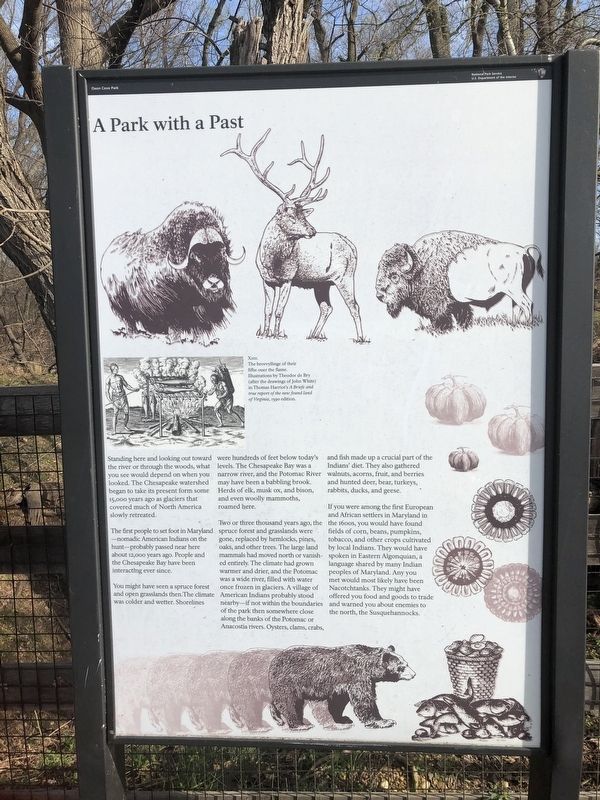
Standing here and looking out toward the river or through the woods, what you see would depend on when you looked. The Chesapeake watershed began to take its present form some 15,000 years ago as glaciers that covered much of North America slowly retreated.
The first people to set foot in Maryland—nomadic American Indians on the hunt—probably passed near here about 12,000 years ago. People and the Chesapeake Bay have been interacting ever since.
You might have seen a spruce forest and open grasslands then. The climate was colder and wetter. Shorelines were hundred of feet below today's levels. The Chesapeake Bay was a narrow river, and the Potomac River may have been a babbling brook. Herds of elk, musk ox, and bison, and even woolly mammoths, roamed here.
Two or three thousand years ago, the spruce forest and grasslands were gone, replaced by hemlocks, pines, oaks, and other trees. The large land mammals had moved north or vanished entirely. The climate had grown warmer and drier, and the Potomac was a wide river, filled with water once frozen in glaciers. A village of American Indians probably stood nearby—if not within the boundaries of the park then somewhere close along the banks of the Potomac or Anacostia rivers. Oysters, clams, crabs, and fish made up a crucial part of the Indians' diets. They also gathered, walnuts, acorns, fruit, and berries and hunted deer, bear, turkeys, rabbits, ducks, and geese.
If you were among the first European and African settlers in Maryland in the 1600s, you would have found fields of corn, beans, pumpkins, tobacco, and other crops cultivated by local Indians. They would have spoken in Eastern Algonquian, a language shared by many Indian peoples of Maryland. Any you met would most likely have been Nacotchtanks. They might have offered you food and goods to trade and warned you about enemies to the north, the Susquehannocks.
Erected by National Park Service, U.S. Department of the Interior.
Topics. This historical marker is listed in these topic lists: Animals • Colonial Era • Environment • Native Americans.
Location. 38° 48.098′ N, 77° 0.288′ W. Marker is in Fort Washington, Maryland, in Prince George's County. Marker can be reached from Bald Eagle Road, 0.2 miles Oxon Hill Road (Maryland Route 414), on the left when traveling north. Touch for map. Marker is at or near this postal address: 6411 Oxon Hill Rd, Oxon Hill MD 20745, United States of America. Touch for directions.
Other nearby markers. At least 8 other markers are within walking distance of this marker. A Voice Unheard… (a few steps from this marker); Oxon Cove Park and Oxon Hill Farm (within shouting distance of this marker); War All Around
Credits. This page was last revised on March 3, 2023. It was originally submitted on March 22, 2020, by Devry Becker Jones of Washington, District of Columbia. This page has been viewed 117 times since then and 12 times this year. Photos: 1, 2. submitted on March 22, 2020, by Devry Becker Jones of Washington, District of Columbia.

