Mount Vernon in Fairfax County, Virginia — The American South (Mid-Atlantic)
The Potomac Watershed
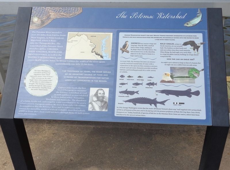
For thousands of years, the river served as an important source of food and a means of transportation for Native American communities in the region.
Captain John Smith, the first known European to encounter the Potomac watershed, arrived in 1608 and found an area inhabited by three Indian tribes—Pamunkey, Powhatan, and Nanticoke. The abundance of wildlife, fertile soil, and navigable water contributed to the area's colonization by European settlers. We know from early 17th-century documentation that the Potomac River and its tributaries were sources for incredible stocks of seafood. Colonists described schools of fish so dense that a boat could not move through them; 14-inch oysters were also common.
(left sidebar)
The name "Potomac" is a European spelling of an Algonquian name which supposedly means "river of swans." Other accounts say the name means "place where people trade" or "the place to which tribute is brought." The Potomac's common spelling through the 18th century was "Patowmack," simplified from the earlier "Patawomeke."
(right sidebar)
George Washington wasn't the only Mount Vernon resident interested in catching fish. Ospreys and bald eagles soar over the shoreline, occasionally diving into the water to seize a fish with their talons.
Ospreys have narrow wings and long legs. They fly with a marked kink in their wings, making an M-shape when seen from below. The tall sycamore tree on the shoreline, adjacent to the wharf, is home to a large osprey nest.
Bald eagles, unique to North America, are not actually bald. The feathers on their heads and tails turn white when they reach maturity. When flying, the bald eagle very rarely flaps its wings but glides instead, holding its wings almost completely flat.
How far can an eagle see?
An eagle's eye is almost as large as that of a human, but an eagle can see a rabbit from one mile away.
At Great Falls, the Potomac becomes an estuary—a partly enclosed coastal body of water with a connection to the open sea that contains a mixture of fresh and salt water. Estuaries provide excellent habitats and breeding grounds for a wide variety of wildlife.
In 1793, George Washington wrote that the
water off Mount Vernon's shore was "well supplied with various kinds of Fish at all Seasons of the year, and in the Spring with the greatest profusion of Shad, Herring, Bass, Carp, Perch, Sturgeon & ca." Today, hundreds of species of fish live in the Potomac River. Some are native, others have been introduced to the area at various times.
Topics. This historical marker is listed in these topic lists: Animals • Exploration • Native Americans • Waterways & Vessels.
Location. 38° 42.31′ N, 77° 5.298′ W. Marker is in Mount Vernon, Virginia, in Fairfax County. Marker can be reached from Mount Vernon Highway (Virginia Route 235) near George Washington Memorial Parkway. Marker is located at the Mount Vernon Wharf, which is on the grounds of George Washington's Mount Vernon estate. Touch for map. Marker is at or near this postal address: 3200 Mount Vernon Hwy, Alexandria VA 22309, United States of America. Touch for directions.
Other nearby markers. At least 8 other markers are within walking distance of this marker. George Washington's Fisheries (here, next to this marker); Preserving the Viewshed (a few steps from this marker); War at our Doorstep (a few steps from this marker); Commerce and Transportation (a few steps from this marker); History of the Wharf (a few steps from this marker); Home of George and Martha Washington / See Mount Vernon From The Water! (within shouting distance of this marker); The Mount Vernon Wharf (within shouting distance of this marker); Visionary Farmer (within shouting distance of this marker). Touch for a list and map of all markers in Mount Vernon.
Credits. This page was last revised on July 17, 2023. It was originally submitted on April 13, 2020, by Jason Voigt of Glen Carbon, Illinois. This page has been viewed 188 times since then and 22 times this year. Photos: 1. submitted on April 13, 2020, by Jason Voigt of Glen Carbon, Illinois. 2. submitted on April 14, 2020, by Jason Voigt of Glen Carbon, Illinois. • Bernard Fisher was the editor who published this page.

