Hanging Rock in Roanoke County, Virginia — The American South (Mid-Atlantic)
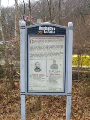
Two Future Presidents In Wartime Retreat
Hanging Rock Battlefield Trail
Colonel Rutherford Birchard Hayes, who would become nineteenth president, commanded the first Brigade of Brigadier General George Crook’s Second Division. The brigade consisted of troops from West Virginia and Ohio, including the 23rd Ohio. A young captain with that regiment was destined to become the twenty-fifth president of the United States. His name was William McKinley.
In addition to the battle at Lynchburg, the 23rd Ohio fought at Carnifex Ferry, Princeton, South Mountain, Antietam, Cloyds Mountain, Berryville, Winchester, Fisher’s Hill, and Cedar Creek.
Although McKinley survived the War Between the States, going on to serve in the United States House of Representatives, as governor of Ohio, and ultimately as president, ironically he was felled by bullets – not from the gunfire of wartime battles, but from an assassin.
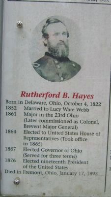
Rutherford B. Hayes
Born in Delaware, Ohio, October 4, 1822
1852 Married to Lucy Ware Webb
1861 Major in the 23rd Ohio (Later commissioned as Colonel, Brevent Major General)
1864 Elected to United States House of Representatives (Took office in 1865)
1867 Elected Governor of Ohio (Served for three terms)
1876 Elected nineteenth President of the United States
Died in Fremont, Ohio, January 17, 1893
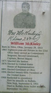
William McKinley
Born in Niles, Ohio, January 29, 1843
1861 Eighteen-year-old Private in the 23rd Ohio (later served as Commissary Sergeant, Second Lieutenant, Captain, Brevet Major)
1871 Married Ida Saxton
1876 Elected to United States House of Representatives
1891 Elected Governor of Ohio
1896 Elected twenty-fifth President of the United States
1900 Reelected to presidency. Shot by assassin in Buffalo, New York, September 6, 1901. Died in Buffalo from bullet wounds, September 14, 1901
Erected 1999 by County of Roanoke, the City of Salem, and the Hanging Rock Battlefield and Railway Preservation Foundation.
Topics and series. This historical marker is listed in these topic lists: Roads & Vehicles • War, US Civil. In addition, it is included in the Former U.S. Presidents: #19 Rutherford B. Hayes, and the Former U.S. Presidents: #25 William McKinley series lists. A significant historical month for this entry is January 1900.
Location. 37° 19.489′ N, 80° 2.49′ W. Marker is in Hanging Rock, Virginia, in Roanoke County. Marker can be reached from the
intersection of Thompson Memorial Drive (Virginia Route 311) and Kessler Mill Drive. Touch for map. Marker is in this post office area: Salem VA 24153, United States of America. Touch for directions.
Other nearby markers. At least 8 other markers are within walking distance of this marker. The Hanging Rock Coal Trestle (about 400 feet away, measured in a direct line); McCausland Attacks (about 600 feet away); George Morgan Jones (approx. ¼ mile away); The Battle of Hanging Rock (approx. ¼ mile away); United Daughters of the Confederacy Monuments (approx. ¼ mile away); Hanging Rock Battlefield Trail (approx. ¼ mile away); a different marker also named Battle of Hanging Rock (approx. ¼ mile away); Hanging Rock (approx. 0.4 miles away). Touch for a list and map of all markers in Hanging Rock.
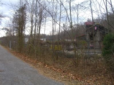
More about this marker. Marker is one of several interpretive signs along the cinder-surfaced, 1.7-mile long Hanging Rock Battlefield Trail that winds along Mason Creek and Kessler Mill Road in Salem, Virginia.
Related markers. Click here for a list of markers that are related to this marker. Other markers mentioning the "two future presidents" who fought in the Shenandoah Valley.
Credits. This page was last revised on December 27, 2019. It was originally submitted on January 7, 2009, by Kevin W. of Stafford, Virginia. This page has been viewed 2,144 times since then and 62 times this year. Photos: 1, 2, 3, 4. submitted on January 7, 2009, by Kevin W. of Stafford, Virginia. • Craig Swain was the editor who published this page.


