Claremont in Los Angeles County, California — The American West (Pacific Coastal)
Cahuilla Park

Photographed by Levi Gonzalez, June 7, 2020
1. Cahuilla Park Marker
By the time Claremont was settled, Indians, who used to live here were on the Morongo Indian Reservation in Riverside County. Since most Indians who lived there were Cahuilla, early residents of Claremont believed that the name of the Indians who lived across Indian Hill Blvd. on the mesa were also Cahuilla. Unfortunately, that is not the case. Cahuilla Indians lived closer to Palm Springs. This park was named for the Indians in 1963, as Claremont's population was expanding rapidly. Citizens voted for a park bond of $875,000 to purchase land for neighborhood parks. $400,000 of that money went to purchase land for this large "community" park. At eighteen acres Cahuilla is the largest developed park in the city. Completed in 1967, the park includes two buildings, the Walter P. Taylor Hall and the Youth Activity Center as well as several playing fields. Taylor was a member of the Claremont City Council from 1960 to 1964 and worked hard to acquire park lands. Since the park's 1967 opening the Guthrie Skate Park has been added as well as a new building for Youth and Family Services.
Topics. This historical marker is listed
this page online
Location. This marker has been replaced by another marker nearby. 34° 6.915′ N, 117° 43.224′ W. Marker is in Claremont, California, in Los Angeles County. It is on Indian Hill Boulevard 0.1 miles south of Scripps Drive, on the right when traveling south. Touch for map. Marker is at or near this postal address: 1717 N Indian Hill Blvd, Claremont CA 91711, United States of America. Touch for directions.

Regionally, this marker is in Greater Los Angeles and in the Transverse Ranges. It is also on the American Pacific Coast. Globally, it is in North America, on the Ring of Fire, on the Pacific Rim, in the Western Hemisphere, in the Western World, and in the Anglosphere. Historically, it finds itself in what was once New Spain and also Mexico’s Alta California.
Other nearby markers. At least 8 other markers are within one mile of this location, measured as the crow flies: Joāt Park (here, next to this marker); Alexander Hughes Community Center (approx. ¾ mile away); Lewis Park (approx.

Photographed by Levi Gonzalez, June 7, 2020
2. Cahuilla Park sign
The marker is on the left side of the sign.
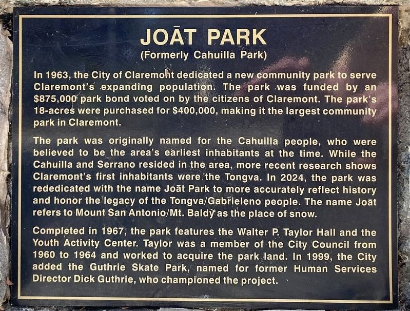
More about this marker. In 2024 this marker was replaced and the park was re-dedicated as Joāt Park.
Photographed by Craig Baker, September 13, 2026
3. Replacement Marker
See Nearby Marker - Joāt Park.
Credits. This page was last revised on September 15, 2026. It was originally submitted on June 21, 2020, by Levi Gonzalez of Rancho Cucamonga, California. This page has been viewed 654 times since then and 76 times this year. Photos: 1, 2. submitted on June 21, 2020, by Levi Gonzalez of Rancho Cucamonga, California. 3. submitted on September 15, 2026, by Craig Baker of Sylmar, California. • J. Makali Bruton was the editor who published this page.
