Fox Point in Providence in Providence County, Rhode Island — The American Northeast (New England)
Providence River Bridge
Its Design and Construction ⎯⎯⎯ Its Journey Up Narragansett Bay by Barges
Providence Harbor Walk at Fox Point & India Point
Photographed by Devry Becker Jones (CC0), June 19, 2020
1. Providence River Bridge Marker
Inscription.
Providence River Bridge. Its Design and Construction, also, Its Journey Up Narragansett Bay by Barges.
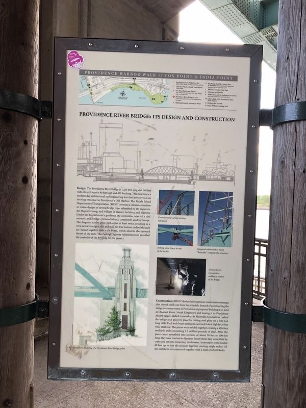
Providence River Bridge: Its Design and Construction. Design: The Providence River Bridge is 1,235 feet long and 164 feet wide. Its arch span is 80 feet high and 400 feet long. This structure is a modern day architectural and engineering feat that also serves as an inviting entrance to Providence's Old Harbor. The Rhode Island Department of Transportation (RIDOT) oversaw a citizens' committee to review designs of several bridge types submitted by the engineers, the Maguire Group, and William D. Warner, Architects and Planners. Under the Department's guidance the committee selected a tied network arch bridge (pictured above), commonly used in Europe. The diagonal cables cross each other at least twice resulting in a very slender and graceful arch and tie. The bottom ends of the arch are linked together with a tie beam, which absorbs the outward thrust of the arch. The Federal Highway Administration provided the majority of the funding for the project., Construction: RIDOT devised an ingenious construction strategy that shaved a full year from the schedule. Instead of constructing the bridge over open water in Providence, it proposed building it on land at Quonset Point, North Kingstown and towing it to Providence aboard barges. Skilled ironworkers in Plainville, Connecticut crafted the bridge arch piece by piece by cutting steel plate on a 170-foot long table. Each arch beam section is a curved 4-foot high by 3-foot wide steel box. The pieces were welded together creating a 400-foot multiple arch containing 5.5 million pounds of steel. After the pieces were assembled into sections of about 50 feet to 100 feet long, they were trucked to quonset Point where they were lifted by crane and set onto temporary steel towers. Ironworkers were hoisted 80 feet up to bolt the sections together creating single arches. All the members are connected together with a total of 65,000 bolts.,
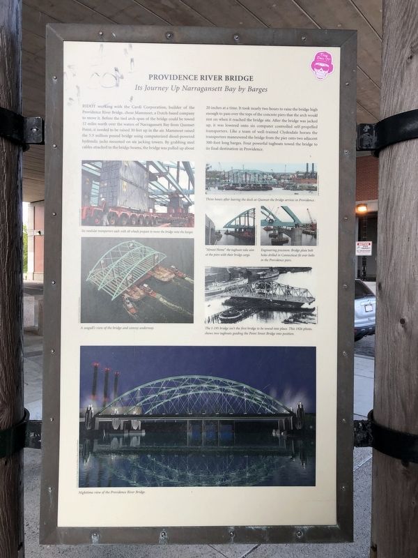
Providence River Bridge Its Journey Up Narragansett Bay by Barges. RIDOT working with the Cardi Corporation, builder of the Providence River Bridge, chose Mammoet, a Dutch-based company to move it. Before the tied arch span of the bridge could be towed 12 miles north over the waters of Narragansett Bay from Quonset Point, it needed to be raised 30 feet up in the air. Mammoet raised the 5.5 million pound bridge using computerized diesel-powered hydraulic jacks mounted on six jacking towers. By grabbing steel cables attached to the bridge beams, the bridge was pulled up about 20 inches at a time. It took nearly two hours to raise the bridge high enough to pass over the tops of the concrete piers that the arch would est on when it reached the bridge site. After the bridge was jacked up, it was lowered onto six computer controlled self-propelled transporters. Like a team of well-trained Clydesdale horses the transporters maneuvered the bridge from the pier onto two adjacent 300-foot long barges. Four powerful tugboats towed the bridge to its final destination in Providence.
Providence River Bridge: Its Design and Construction
Design: The Providence River Bridge is 1,235 feet long and 164 feet wide. Its arch span is 80 feet high and 400 feet long. This structure is a modern day architectural and engineering feat that also serves as an inviting entrance to Providence's Old Harbor. The Rhode Island Department of Transportation (RIDOT) oversaw a citizens' committee to review designs of several bridge types submitted by the engineers, the Maguire Group, and William D. Warner, Architects and Planners. Under the Department's guidance the committee selected a tied network arch bridge (pictured above), commonly used in Europe. The diagonal cables cross each other at least twice resulting in a very slender and graceful arch and tie. The bottom ends of the arch are linked together with a tie beam, which absorbs the outward thrust of the arch. The Federal Highway Administration provided the majority of the funding for the project.
Construction: RIDOT devised an ingenious construction strategy that shaved a full year from the schedule. Instead of constructing the bridge over open water in Providence,
Click or scan to see this page online
it proposed building it on land at Quonset Point, North Kingstown and towing it to Providence aboard barges. Skilled ironworkers in Plainville, Connecticut crafted the bridge arch piece by piece by cutting steel plate on a 170-foot long table. Each arch beam section is a curved 4-foot high by 3-foot wide steel box. The pieces were welded together creating a 400-foot multiple arch containing 5.5 million pounds of steel. After the pieces were assembled into sections of about 50 feet to 100 feet long, they were trucked to quonset Point where they were lifted by crane and set onto temporary steel towers. Ironworkers were hoisted 80 feet up to bolt the sections together creating single arches. All the members are connected together with a total of 65,000 bolts.
Providence River Bridge Its Journey Up Narragansett Bay by Barges
RIDOT working with the Cardi Corporation, builder of the Providence River Bridge, chose Mammoet, a Dutch-based company to move it. Before the tied arch span of the bridge could be towed 12 miles north over the waters of Narragansett Bay from Quonset Point, it needed to be raised 30 feet up in the air. Mammoet
Photographed by Devry Becker Jones (CC0), June 19, 2020
2. Providence River Bridge Marker
raised the 5.5 million pound bridge using computerized diesel-powered hydraulic jacks mounted on six jacking towers. By grabbing steel cables attached to the bridge beams, the bridge was pulled up about 20 inches at a time. It took nearly two hours to raise the bridge high enough to pass over the tops of the concrete piers that the arch would est on when it reached the bridge site. After the bridge was jacked up, it was lowered onto six computer controlled self-propelled transporters. Like a team of well-trained Clydesdale horses the transporters maneuvered the bridge from the pier onto two adjacent 300-foot long barges. Four powerful tugboats towed the bridge to its final destination in Providence. (Marker Number 4.)
Location. 41° 48.954′ N, 71° 24.029′ W. Marker is in Providence, Rhode Island, in Providence County. It is in Fox Point. It is at the intersection of Bridge Street and India Street, on the left when traveling north on
Photographed by Devry Becker Jones (CC0), June 19, 2020
3. Providence River Bridge Marker
Bridge Street. Touch for map. Marker is at or near this postal address: 661 S Water St, Providence RI 02903, United States of America. Touch for directions.
Regionally, this marker is on Rhode Island’s Narragansett Bay. It is also in the American Northeast and in New England. Globally, it is in the North Atlantic Region, North America, the Western Hemisphere, the Western World, and the Anglosphere. Historically, it finds itself in what was once one of the original Thirteen Colonies.
Credits. This page was last revised on February 8, 2023. It was originally submitted on June 22, 2020, by Devry Becker Jones of Washington, District of Columbia. This page has been viewed 648 times since then and 36 times this year. Photos:1, 2, 3. submitted on June 22, 2020, by Devry Becker Jones of Washington, District of Columbia.