Downtown Providence in Providence County, Rhode Island — The American Northeast (New England)
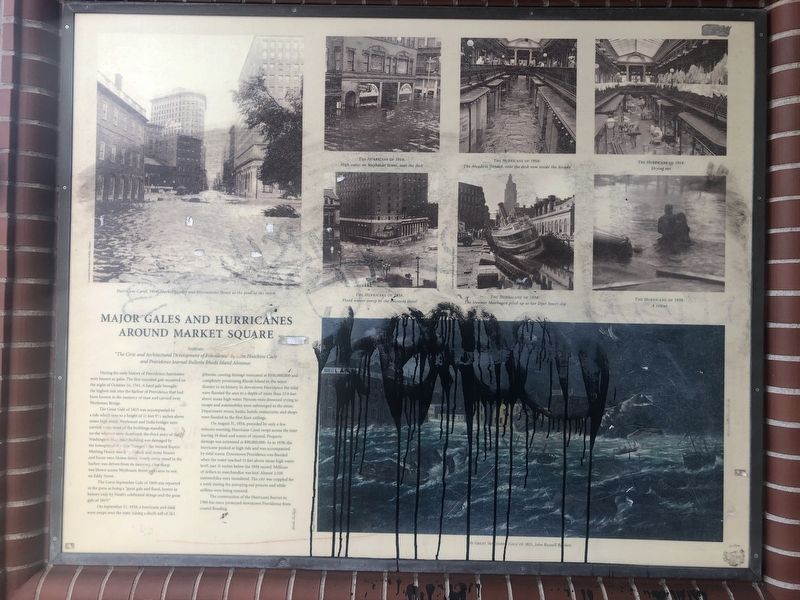
Major Gales and Hurricanes around Market Square
Sources: "The Civic and Architectural Development of Providence" by John Hutchins Cady
| — | and Providence Journal Bulletin Rhode Island Almanac | — |
Photographed by Devry Becker Jones (CC0), June 19, 2020
1. Major Gales and Hurricanes around Market Square Marker
During the early history of Providence, hurricanes were known as gales. The first recorded gale occurred on the night of October 24, 1761. A hard gale brought the highest tide into the harbor of Providence that had been known in the memory of man and carried away Weybosset Bridge.
The Great Gale of 1815 was accompanied by a tide which rose to a height of 11 feet 9½ inches above mean high water. Weybosset and India bridges were carried away; most of the buildings standing on the wharves were destroyed; the third story of the Washington Insurance Building was damaged by the bowsprit of the ship "Ganges"; the Second Baptist Meeting House was demolished; and many houses and barns were blown down. Nearly every vessel in the harbor was driven from its mooring. One sloop was blown across Weybosset Street and came to rest on Eddy Street.
The Great September Gale of 1869 was reported in the press as being a "great gale and flood, beaten in history only by Noah's celebrated deluge and the great gale of 1815!"
On September 21, 1938, a hurricane and tidal wave swept over the state, taking a death toll of 262 person, causing
this page online
On August 31, 1954, preceded by only a few minutes warning, Hurricane Carol swept across the state leaving 19 dead and scores of injured. Property damage was estimated at $90,000,000. As in 1938, the hurricane peaked at high tide and was accompanied by tidal waves. Downtown Providence was flooded when the water reached 13 feet above mean high water level, just 11 inches below the 1938 record. Millions of dollars in merchandise was lost. Almost 3,500 automobiles were inundated. The city was crippled for a week during the pumping out process and while utilities were being restored.
The construction of the Hurricane River in 1966 has been protected downtown Providence from coastal flooding.
Topics and series. This historical marker is listed in these topic lists: Bridges & Viaducts • Disasters • Roads & Vehicles • Waterways & Vessels. In addition, it is included in the Lost at Sea series list. A significant historical date for this entry is October 24, 1761.
Location. 41° 49.524′ N, 71° 24.547′ W. Marker has been reported damaged. Marker is in Providence, Rhode Island, in Providence County. It is in Downtown Providence. It is at the intersection of Westminster Street and Memorial Boulevard (U.S. 44), on the right when traveling west on Westminster Street. Touch for map. Marker is at or near this postal address: 11 Westminster St, Providence RI 02903, United States of America. Touch for directions.

Regionally, this marker is on Narragansett Bay. It is also in the American Northeast, in New England, and on the Eastern Seaboard. Globally, it is in the North Atlantic Region, North America, the Western Hemisphere, the Western World, and the Anglosphere. Historically, it finds itself in what was once one of the original Thirteen Colonies.
Other nearby markers. At least 8 other markers are within walking distance of this location: Across the River from Market Square (here, next to this marker); The Hurricane of September 21, 1938 (within shouting distance of this marker); Great Gale of September 23, 1815 (within shouting distance of this marker); Around the Corner from Market Square (within shouting distance of this marker); The History of The Weybosset Bridge (within shouting distance of this marker); The Hurricane of September 21st 1938 (within shouting distance of this marker); Luigi Scala (within shouting distance of this marker); United States Merchant Marine Memorial (about 300 feet away, measured in a direct line). Touch for a list and map of all markers in Providence.
Credits. This page was last revised on February 8, 2023. It was originally submitted on June 22, 2020, by Devry Becker Jones of Washington, District of Columbia. This page has been viewed 315 times since then and 30 times this year. Photo 1. submitted on June 22, 2020, by Devry Becker Jones of Washington, District of Columbia.
Editor’s want-list for this marker. A wide shot of the marker in context • Can you help?
