Vieux-Québec-Cap-Blanc-colline Parlementaire in Capitale-Nationale, — Central Canada (French-Canadian)
Le Parc La Cetière
⎯⎯⎯
La Cetière Park

Photographed by Cosmos Mariner, August 4, 2019
1. Le Parc La Cetière / La Cetière Park Marker

Au détour du chemin qui mène à la Haute-Ville
Entre 1650 et 1660, le gouverneur de la Nouvelle-France, Jean de Lauzon, concède les terrains aujourd'hui occupés par le parc La Cetière. Les nouveaux propriétaires s'empressent d'y faire bâtir maison.
Jacques Maheu est l'un d'eux. Il possède quatre terres dans les environs de Québec. Il élève quelques animaux et s'adonne à la culture, à la chasse et à la pêche.
At the bend in the road to Upper Town
Between 1650 and 1660, the Governor of New France, Jean de Lauzon, ceded the lots on which the parc La Cetiere stands. The new owners quickly built houses on their property.
Jacques Maheu was one of them. He owned four pieces of land around Quebec. He raised a few animals and busied himself with farming, hunting and fishing.
Topics. This historical marker is listed in these topic lists: Colonial Era • Parks & Recreational Areas • Settlements & Settlers. A significant historical year for this entry is 1650.
Location. 46° 48.821′ N, 71° 12.192′ W. Marker is in Québec, in Capitale-Nationale. It is in Vieux-Québec-Cap-Blanc-colline Parlementaire. It is on Rue
this page online

Regionally, this marker is in Central Canada. Globally, it is in North America, the Western Hemisphere, and the Western World. Historically, it finds itself in what was once a British colony, the Viceroyalty of New France, the Haudenosaunee (Iroquois) Confederacy, and Rupert’s Land.
Other nearby markers. At least 8 other markers are within walking distance of this marker: À la française… / French Style… (here, next to this marker); Les vestiges des maisons Gaillard et Soulard (here, next to this marker); Un horloger bien de son temps / A clock-maker of the time (here, next to this marker); L'hôtel Mountain Hill et Le Soleil (a few steps from this marker); La Fresque des Québécois / The Mural of Quebecers (a few steps from this marker); Urselines de Quebec (within shouting distance of this marker); Charles Aubert de la Chesnaye
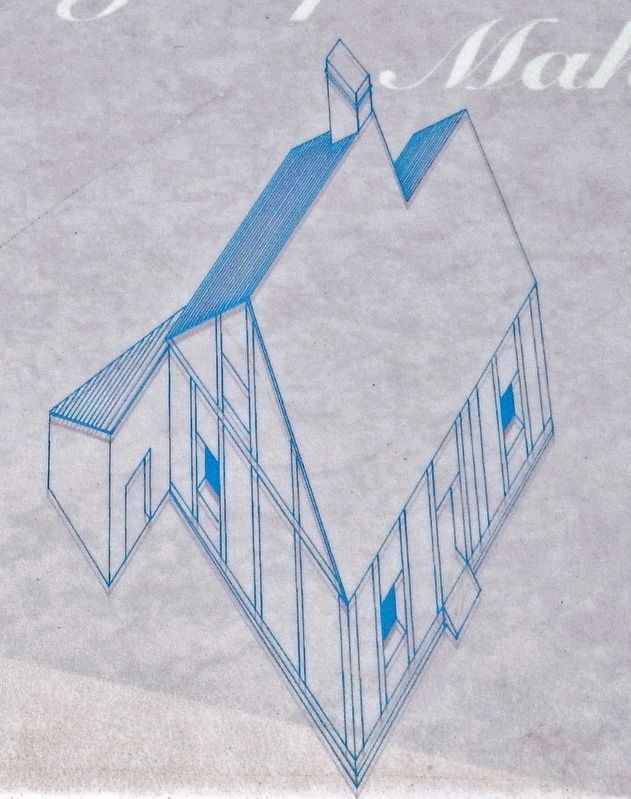
2. Marker detail: Maison Jacques Maheu / Jacques Maheu House
• • •
Reconstruction of Jacques Maheu's half-timbered house. The frame is made of posts set at regular intervals; the spaces between are filled with a mixture of stone and mortar, and covered with a coat of wet dash. (Drawing: Robert Côté, Musée de la civilisation, archives of the Musée de l’Amérique française, Place-Royale collection.)
Related markers. Click here for a list of markers that are related to this marker. Parc de la Cetière

Photographed by Ministère de la Culture et des Communications, IQU2154b-8
3. Marker detail: Ministère de la Culture et des Communications, IQU2154b-8
• • •
French stoneware pots containing salted butter from Normandy were found ln Jacques Maheu 's cellar.

Photographed by Cosmos Mariner, August 4, 2019
4. Le Parc La Cetière / La Cetière Park Marker
Credits. This page was last revised on February 9, 2023. It was originally submitted on July 11, 2020, by Cosmos Mariner of Cape Canaveral, Florida. This page has been viewed 1,325 times since then and 134 times this year. Photos: 1. submitted on July 12, 2020, by Cosmos Mariner of Cape Canaveral, Florida. 2, 3, 4. submitted on July 14, 2020, by Cosmos Mariner of Cape Canaveral, Florida.
