Wharton Township near Farmington in Fayette County, Pennsylvania — The American Northeast (Mid-Atlantic)
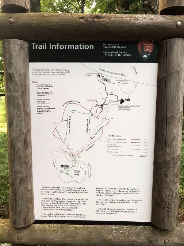
Trail Information
Fort Necessity National Battlefield
— National Park Service, U.S. Department of the Interior —
Portions of this trail system pass through the Great Meadows where George Washington and his troops fought a large French and Indian force on July 3, 1754.
The Braddock Road Trace is the remnant of the road built by Washington in 1754 and improved by General Braddock's army the next year. This road became one of the major routes of transportation from the east before the completion of the National Road.
The trails wind through the mixed deciduous forest. When Washington and his men passed through this area, the forest had never been logged. The trees were large and well spaced with the absence of the undergrowth due to the shade of the trees.
The stand of pine the trail passes through are the legacy of Civilian Conservation Corps of the 1930's.
Although changed over time, the park still offers today's explorers an opportunity to imagine a time passed.
Erected by National Park Service, U.S. Department of the Interior.
Topics and series. This historical marker is listed in these topic lists: Colonial Era • Forts and Castles • Roads & Vehicles • War, French and Indian . In addition, it is included in the Braddock’s Road and Maj. Gen. Edward Braddock, the Civilian Conservation Corps (CCC), and the The Historic National Road series lists. A significant historical date for this entry is July 3, 1754.
Location. 39° 48.629′ N, 79° 35.737′ W. Marker is near Farmington, Pennsylvania, in Fayette County. It is in Wharton Township. Marker is on Washington Parkway, 0.8 miles south of National Pike (U.S. 40), on the right when traveling south. Touch for map. Marker is in this post office area: Farmington PA 15437, United States of America. Touch for directions.
Other nearby markers. At least 8 other markers are within walking distance of this marker. Surrender Negotiations (approx. 0.4 miles away); The French Attack (approx. 0.4 miles away); British Defenses (approx. half a mile away); Fort Necessity (approx. half a mile away); Building Fort Necessity (approx. half a mile away); Do you measure up in Washington's Army? / Are you dressed for the campaign? (approx. 0.6 miles away); Civilian Conservation Corps at Fort Necessity (approx. 0.6 miles away); The Great Meadows Campaign (approx. 0.6 miles away). Touch for a list and map of all markers in Farmington.
Additional commentary.
1. Duplicates
There are duplicates of the marker
— Submitted July 13, 2020, by Devry Becker Jones of Washington, District of Columbia.
Credits. This page was last revised on February 7, 2023. It was originally submitted on July 12, 2020, by Devry Becker Jones of Washington, District of Columbia. This page has been viewed 225 times since then and 8 times this year. Photos: 1, 2. submitted on July 12, 2020, by Devry Becker Jones of Washington, District of Columbia.

