Spokane in Spokane County, Washington — The American West (Northwest)
Spokane County Conservation Futures Program
Inscription.
"There can be no greater issue than that of conservation in this country."
—Theodore Roosevelt, 1912
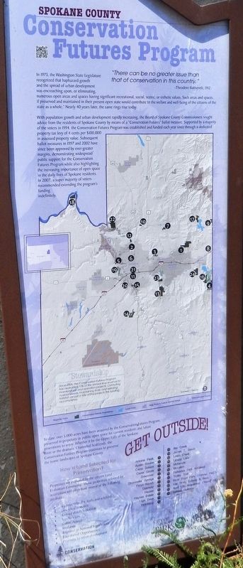
In 1973, the Washington State Legislature recognized that haphazard growth and the spread of urban development was encroaching upon, or eliminating, numerous open areas and spaces having significant recreational, social, scenic, or esthetic values. Such areas and spaces, if preserved and maintained in their present open state would contribute to the welfare and well-being of the citizens of the state as a whole. Nearly 40 years later, the same rings true today.
With population growth and urban development rapidly increasing, the Board of Spokane County Commissioners sought advice from the residents of Spokane County by means of a "Conservation Futures" ballot measure. Supported by a majority of the voters in 1994, the Conservation Futures Program was established and funded each year since through a dedicated property tax levy of 4 cents per $100,000 in assessed property value. Subsequent ballot measures in 1997 and 2002 have since been approved by ever-greater margins, demonstrating widespread public support for the Conservation Futures Program while also highlighting the increasing importance of open space in the daily lives of Spokane residents. In 2007, a super majority of voters recommended extending the programs funding indefinitely.
To date, over 5,000 acres have been acquired by the Conservation Futures Program, preserved in perpetuity as a public open space for current residents and future generations to enjoy. Whether it be the Upper Falls of the Spokane River or the dramatic Channeled Scablands, the Conservations Futures Program continues to preserve the iconic landscapes of Spokane County.
How is Land Selected for Preservation?
Properties are evaluated by the citizen Land Evaluation Committee. Those properties selected for acquisition will often have several of the following attributes:
Connectivity (for trails and wildlife)
Shoreline Features
Critical Wildlife Habitat
Scenic Views
Public Access
Wetlands
Regional or National Significance
Educational Opportunities
Proximity to urban development
Stewardship
Since 2005, the Conservation Futures Program has dedicated 15% of the annual levy revenue to maintenance and operations projects. Controlling noxious weeds, maintaining trails, and restoring habitat are just a few of the projects this funding accomplishes.
Erected by City of Spokane Parks Recreation.
Topics. This historical marker is listed in these topic lists: Environment • Parks & Recreational Areas. A significant historical year for this entry is 1994.
Location.

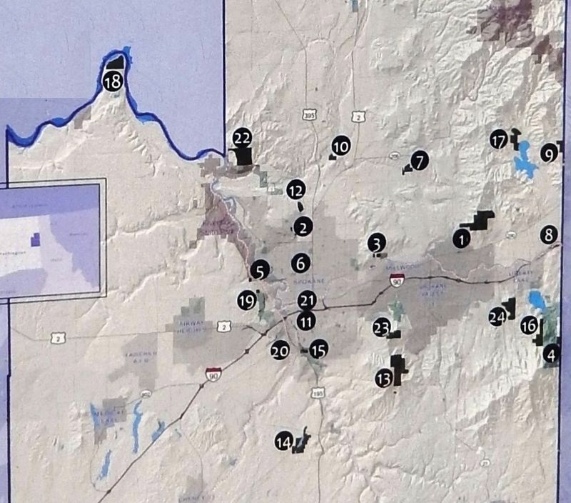
2. Marker detail: Conservation Futures Acquisition Map
1. Antoine Peak 2. Austin Ravine 3. Camp Sekani 4. Cedar Grove 5. Downriver 6. Drumheller Springs 7. Feryn Ranch 8. Gateway 9. Hauser 10. Haynes Estate 11. High Drive 12. Holmberg 13. Iller Creek 14. James T. Slavin 15. Latah Creek 16. Liberty Lake 17. McKenzie 18. McLellan 19. Palisades Park Addition 20. Trolley Trail 21. River Front Park (Former YMCA) 22. Van Horn, Edburg & Bass 23. April 2016 Acquisition 24. Saltese Uplands
Click for more information.
Click for more information.
Other nearby markers. At least 8 other markers are within walking distance of this marker. The Great Fire of 1889 (about 300 feet away, measured in a direct line); Canada Island Resolution (about 400 feet away); Havermale Island Pioneer Stronghold (about 500 feet away); Great Northern Railway Passenger Depot Clock Tower (about 700 feet away); Early Spokane (about 700 feet away); Post Street Substation (approx. 0.2 miles away); Spokane's Electric Streetcars (approx. 0.2 miles away); Post Street Bridge (approx. 0.2 miles away). Touch for a list and map of all markers in Spokane.
Also see . . . Conservation Futures Program. Spokane County Parks, Recreation & Golf entry:
As of July 2020, the Conservation Futures Program has acquired over 9,145 acres through 52 acquisitions owned and managed by Spokane County, City of Spokane, and City of Cheney. (Submitted on August 5, 2020, by Cosmos Mariner of Cape Canaveral, Florida.)
Credits. This page was last revised on February 28, 2022. It was originally submitted on August 5, 2020, by Cosmos Mariner of Cape Canaveral, Florida. This page has been viewed 147 times since then and 13 times this year. Photos: 1, 2, 3. submitted on August 5, 2020, by Cosmos Mariner of Cape Canaveral, Florida.

