Mackinaw City in Emmet County, Michigan — The American Midwest (Great Lakes)
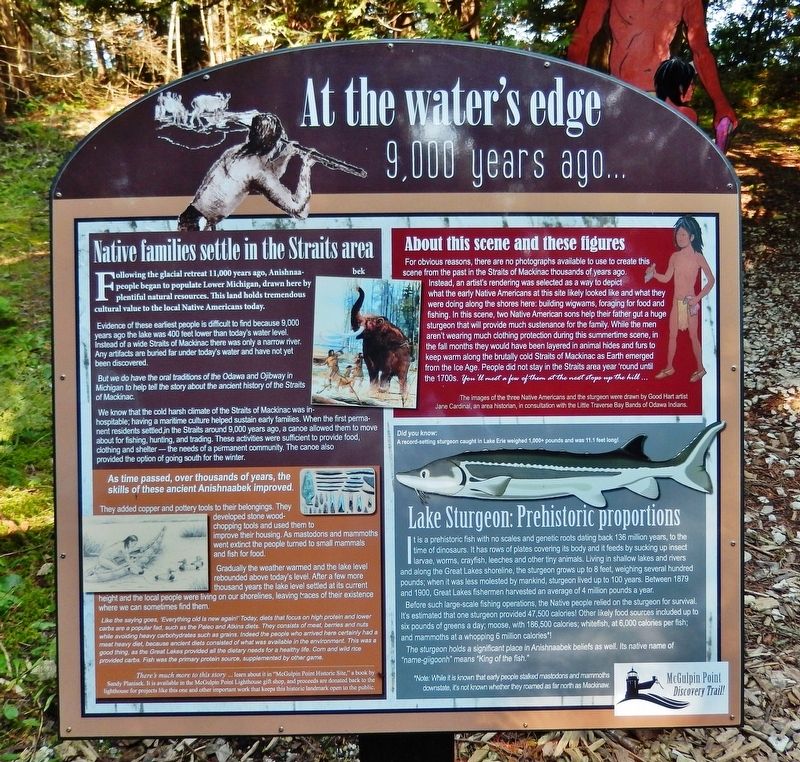
At the Water's Edge
9,000 years ago...
Following the glacial retreat 11,000 years ago, Anishnaabek people began to populate Lower Michigan, drawn here by plentiful natural resources. This land holds tremendous cultural value to the local Native Americans today.
Evidence of these earliest people is difficult to find because 9,000 years ago the lake was 400 feet lower than today's water level. Instead of a wide Straits of Mackinac there was only a narrow river. Any artifacts are buried far under today's water and have not yet been discovered.
But we do have the oral traditions of the Odawa and Ojibway in Michigan to help tell the story about the ancient history of the Straits of Mackinac.
We know that the cold harsh climate of the Straits of Mackinac was inhospitable; having a maritime culture helped sustain early families. When the first permanent residents settled in the Straits around 9,000 years ago, a canoe allowed them to move about for fishing, hunting, and trading. These activities were sufficient to provide food, clothing and shelter — the needs of a permanent community. The canoe also provided the option of going south for the winter.
As time passed, over thousands of years, the skills of these ancient Anishnaabek improved.
They added copper and pottery tools to their belongings. They developed stone wood-chopping tools and used them to improve their housing. As mastodons and mammoths went extinct the people turned to small mammals and fish for food.
Gradually the weather warmed and the lake level rebounded above today's level. After a few more thousand years the lake level settled at its current height and the local people were living on our shorelines, leaving traces of their existence where we can sometimes find them.
Like the saying goes, “Everything old is new again!” Today, diets that focus on high protein and lower carbs are a popular fad, such as the Paleo and Atkins diets. They consist of meat, berries and nuts while avoiding heavy carbohydrates such as grains. Indeed the people who arrived here certainly had a meat heavy diet, because ancient diets consisted of what was available in the environment. This was a good thing, as the Great Lakes provided all the dietary needs for a healthy life. Corn and wild rice provided carbs. Fish was the primary protein source, supplemented by other game.
About this scene and these figures
For obvious reasons, there are no photographs available to use to create this scene from the past in the Straits of Mackinac thousands of years ago. Instead, an artist's rendering was selected as a way to depict what the early Native Americans at this site likely
looked like and what they were doing along the shores here: building wigwams, foraging for food and fishing. In this scene, two Native American sons help their father gut a huge sturgeon that will provide much sustenance for the family. While the men aren't wearing much clothing protection during this summertime scene, in the fall months they would have been layered in animal hides and furs to keep warm along the brutally cold Straits of Mackinac as Earth emerged from the Ice Age. People did not stay in the Straits area year 'round until the 1700s. You’ll meet a few of them at the next stops up the hill…
The images of the three Native Americans and the sturgeon were drawn by Good Hart artist Jane Cardinal, an area historian, in consultation with the Little Traverse Bay Bands of Odawa Indians.
Lake Sturgeon: Prehistoric proportions
Did you know: A record-breaking sturgeon caught in Lake Erie weighed 1,000+ pounds and was 11.1 feet long!
It is a prehistoric fish with no scales and genetic roots dating back 136 million years, to the time of dinosaurs. It has rows of plates covering its body and it feeds by sucking up insect larvae, worms, crayfish, leeches and other tiny animals. Living in shallow lakes and rivers and along the Great Lakes shoreline, the sturgeon grows up to 8 feet, weighing several hundred pounds; when it was less molested by mankind, sturgeon lived up to 100 years. Between 1879 and 1900, Great Lakes fishermen harvested an average of 4 million pounds a year.
Before such large-scale fishing operations, the Native people relied on the sturgeon for survival. It's estimated that one sturgeon provided 47,500 calories! Other likely food sources included up to six pounds of greens a day; moose, with 186,500 calories; whitefish, at 6,000 calories per fish; and mammoths at a whopping 6 million calories*!
The sturgeon holds a significant place in Anishnaabek beliefs as well. Its native name of "name-giigoonh" means "King of the fish."
*Note: While it is known that early people stalked mastodons and mammoths downstate, it’s not known whether they roamed as far north as Mackinaw.
There's much more to this story… learn about it in "McGulpin Point Historic Site," a book by Sandy Planisek. It is available in the McGulpin Point Lighthouse gift shop, and proceeds are donated back to the lighthouse fur projects like this one and other important work that keeps this historic landmark open to the public.
Topics. This historical marker is listed in these topic lists: Animals • Anthropology & Archaeology • Native Americans • Waterways & Vessels.
Location. 45° 47.349′ N, 84° 46.364′ W. Marker is in Mackinaw City, Michigan, in Emmet County. Marker can be reached from Headlands Road north of McGulpin Point Road, on the right when traveling north. Marker is located along the Discovery Trail at McGulpin Point Lighthouse & Historic Site. Touch for map. Marker is at or near this postal address: 500 Headlands Road, Mackinaw City MI 49701, United States of America. Touch for directions.
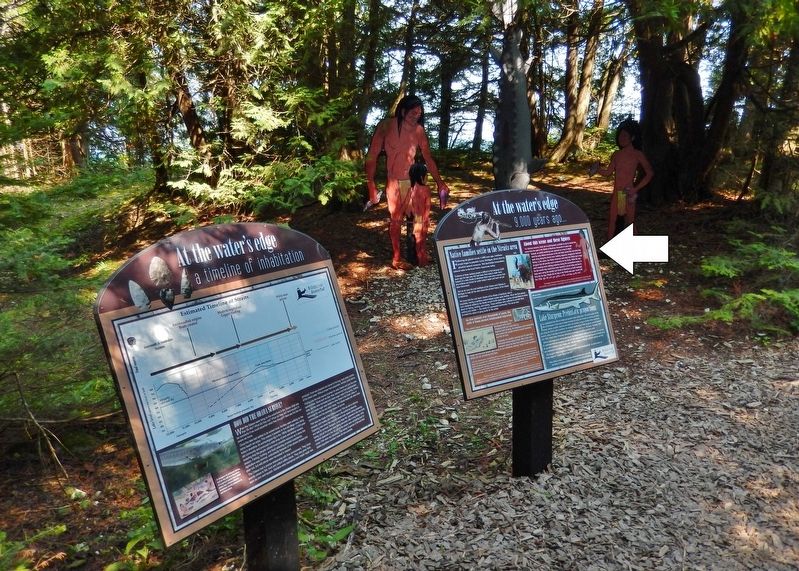
Other nearby markers. At least 8 other markers are within walking distance of this marker. At The Water's Edge (here, next to this marker); Warrior, brother & leader (within shouting distance of this marker); Charles de Langlade (about 500 feet away, measured in a direct line); Settling the Straits (about 600 feet away); McGulpin Family Life (about 700 feet away); William H. Barnum (about 700 feet away); Minneapolis (about 700 feet away); James W. Bennett (about 700 feet away). Touch for a list and map of all markers in Mackinaw City.
Related markers. Click here for a list of markers that are related to this marker. Discovery Trail to the Straits of Mackinac
Also see . . . Discovery Trail to the Straits of Mackinac. At the edge of the water you will meet a traditional Native family from 9,000 years ago. (Submitted on August 16, 2020, by Cosmos Mariner of Cape Canaveral, Florida.)
Credits. This page was last revised on August 17, 2020. It was originally submitted on August 12, 2020, by Cosmos Mariner of Cape Canaveral, Florida. This page has been viewed 136 times since then and 5 times this year. Photos: 1, 2. submitted on August 15, 2020, by Cosmos Mariner of Cape Canaveral, Florida.

