Gravelly Point Park in Arlington in Arlington County, Virginia — The American South (Mid-Atlantic)
A Roadside Respite
George Washington Memorial Parkway | Roaches Run Waterfowl Sanctuary
| — | National Park Service, U.S. Department of the Interior | — |
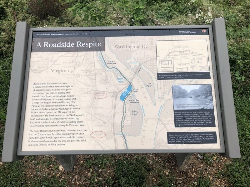
Roaches Run Waterfowl Sanctuary, a nature preserve that hosts many species of migratory birds, included a designed recreational road pull-off parking area intended as a feature of the Mount Vernon Memorial Highway, the original portion of the George Washington Memorial Parkway. The Parkway, which initially ran just from Arlington Memorial Bridge to George Washington's Mount Vernon estate, opened in 1932 as part of the celebration of the 200th anniversary of Washington's birth and served as a scenic roadway connecting historic sites related to his life while providing access to recreational opportunities along the Potomac River.
The name Roaches Run is attributed to a creek emptying into the Potomac near here that was on property once owned by James Roach, a prominent mid-19th century businessman who resided in the area and provided brick and stone for local building projects.
[Caption:]
Facilities at Roaches Run were created in 1935 by members of the Civilian Conservation Corps (CCC), one of President Franklin Roosevelt's New Deal work relief programs. CCC enrollees from Camp NP-6-VA at Fort Hunt constructed the parking area, planted trees, built a trail encircling Roaches Run, and constructed a feed shed and game warden's cabin on the far west side.
Erected by National
this page online
Topics and series. This historical marker is listed in these topic lists: Animals • Charity & Public Work • Roads & Vehicles • Waterways & Vessels. In addition, it is included in the Civilian Conservation Corps (CCC), the Former U.S. Presidents: #01 George Washington, and the Former U.S. Presidents: #32 Franklin D. Roosevelt series lists. A significant historical year for this entry is 1932.
Location. 38° 51.907′ N, 77° 2.523′ W. Marker is in Arlington, Virginia, in Arlington County. It is in Gravelly Point Park. It is on George Washington Memorial Parkway 1½ miles south of 14th Street Bridge (Interstate 395), on the right when traveling south. Touch for map. Marker is in this post office area: Arlington VA 22202, United States of America. Touch for directions.

Regionally, this marker is in the Washington Metropolitan Area and in Northern Virginia. It is also in the American South, specifically in the Upper South, in the Mid-Atlantic, and on the Eastern Seaboard. Globally, it is in the North Atlantic Region, North America, the Western Hemisphere, the Western World,
Other nearby markers. At least 8 other markers are within walking distance of this marker: Ronald Reagan Washington National Airport & George Washington Memorial Parkway (about 600 feet away, measured in a direct line); a different marker also named From Brownfield to Playing Fields (approx. ¼ mile away); Arlington's Natural Side (approx. ¼ mile away); Long Bridge Park: A Legacy of Recreation (approx. ¼ mile away); A Historic Junction (approx. ¼ mile away); Looking Beyond the Park (approx. ¼ mile away); Significance of Roaches Run Sanctuary (approx. 0.3 miles away); New and Renewed Land (approx. 0.3 miles away). Touch for a list and map of all markers in Arlington.
Other markers no longer nearby. From Brownfield to Playing Fields (was approx. ¼ mile away but has been replaced with another marker now near it); Long Bridge Park: A Community Space (was approx. ¼ mile away but has been replaced with another
Credits. This page was last revised on March 3, 2023. It was originally submitted on September 26, 2020, by Devry Becker Jones of Washington, District of Columbia. This page has been viewed 1,540 times since then and 62 times this year. Photos: 1, 2, 3. submitted on September 26, 2020, by Devry Becker Jones of Washington, District of Columbia.
