Fort Smith in Sebastian County, Arkansas — The American South (West South Central)
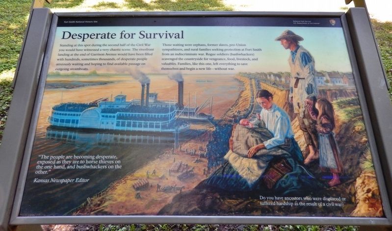
Desperate For Survival
Fort Smith National Historic Site
— National Park Service, U.S. Department of the Interior —
Those waiting were orphans, former slaves, pro-Union sympathizers, and rural families seeking protection at Fort Smith from an indiscriminate war. Rogue soldiers (bushwhackers) scavenged the countryside for vengeance, food, livestock, and valuables. Families, like this one, left everything to save themselves and begin a new life — without war.
”The people are becoming desperate, exposed as they are to horse thieves on the one hand, and bushwhackers on the other.”
—Kansas Newspaper Editor
Do you have ancestors who were displaced or suffered hardship as the result of a civil war?
Erected by National Park Service, U.S. Department of the Interior.
Topics. This historical marker is listed in these topic lists: Settlements & Settlers • War, US Civil • Waterways & Vessels.
Location. 35° 23.416′ N, 94° 25.908′ W. Marker is in Fort Smith, Arkansas, in Sebastian County. Marker can be reached from the intersection of Parker Avenue and South 3rd Street. Marker is located on the Fort Smith National Historic Site grounds, near Belle Point on the west side of the fort. Touch for map. Marker is at or near this postal address: 301 Parker Avenue, Fort Smith AR 72901, United States of America. Touch for directions.
Other nearby markers. At least 8 other markers are within walking distance of this marker. Old Commissary (about 600 feet away, measured in a direct line); A Building Worth Saving (about 700 feet away); Frisco Train Depot (about 700 feet away); The Bastion That Never Was (about 700 feet away); Officer’s Garden (about 700 feet away); Belle Point (about 800 feet away); Whiskey War (approx. 0.2 miles away); The Officer’s Quarters (approx. 0.2 miles away). Touch for a list and map of all markers in Fort Smith.
Also see . . . The Civil War at Fort Smith. By the spring of 1865, the Civil War in the area around Fort Smith had became a bitter guerrilla conflict that would actually continue for years to come as outlaw bands roamed the mountains of both Arkansas and the Indian Nations of what is now Oklahoma, preying on innocents and battling against the law. (Submitted on September 30, 2020, by Cosmos Mariner of Cape Canaveral, Florida.)
Credits. This page was last revised on September 30, 2020. It was originally submitted on September 28, 2020, by Cosmos Mariner of Cape Canaveral, Florida. This page has been viewed 218 times since then and 56 times this year. Photos: 1, 2. submitted on September 30, 2020, by Cosmos Mariner of Cape Canaveral, Florida.

