Near Wisconsin Dells in Columbia County, Wisconsin — The American Midwest (Great Lakes)
Indians -- Flora & Fauna
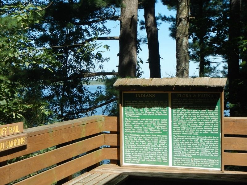
Indian tribes have lived in this area of Wisconsin for centuries. Jean Nicolet, a French Government representative, was the first white man to have contact with the Indians in 1634. At that time, the tribes living in central Wisconsin were the Chippewa, Sioux, Sac, Memoninee and the main tribe of the Dells are - the Winnebago.
The Indian tribes made artistic pottery, hunted buffalo, raised corn and squash on nearby plains, and fished the river. The Winnebago Indians called the river "Meskousing," meaning "where the waters water." The French spelled the Indian term "Ouisconsin," thus naming the Wisconsin River and the state.
The Winnebagos were forced from their lands to Nebraska, where they were unable to live on the dry, flat plains. Most of them returned under their last leader, Chief Yellow Thunder, who took out a land grant and settled a homestead a few miles south of the Dells. Most of the Indians who reside in the area today are descendants of this tribe. The Indians of the Dells area can be seen performing their tribal dances at the famous and colorful Stand Rock Indian Ceremonial. It was here, at the natural amphitheater near Stand Rock, that tribal council meetings and celebrations took place many years ago.
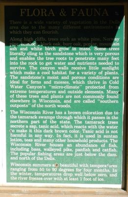
There is a wide variety of vegetation in the Dells area due to the many different environments in which they can flourish.
Along high cliffs trees such as white pine, Norway pine, hemlock, black oak, burr oak, poplar mountain ash and white birch grow in mass. Some trees literally cling to the sandstone which is very porous and enables the tree roots to penetrate many feet into the rock to get water and nutrients need t survive. The canyon walls receive little sunlight which make a cool habitant for a variety of plants. The sandstone's moist and porous conditions are ideal for ferns and mosses, which thrive in Cold Water Canyon's "micro-climate" protected from extreme temperatures and outside elements. Many of these trees and plants are not commonly found elsewhere in Wisconsin, and are called "southern outposts" of the north woods.
The Wisconsin River has a brown coloration due to the tamarack swamps through which it passes in the northern part of the state. The tamarack trees secrete a sap, tanic acid, which reacts with the water to make it this dark brown color. Tanic acid is not harmful in any way. In fact, it is used in suntan location, teas and many other household products. The Wisconsin River houses an abundance of fish, including bass, walleyed pike, panfish and catfish. The popular fishing areas are just below the dam, and north of the Dells.
Wisconsin summers are beautiful with temperatures ranging from 50 to 90 degrees for four months. In the winter, temperatures drop well below zero, and the river freezes over with at least 1 foot of ice.
Erected by Dells Boat Tours.
Topics. This historical marker is listed in these topic lists: Native Americans • Natural Features • Waterways & Vessels. A significant historical year for this entry is 1634.
Location. 43° 40.521′ N, 89° 48.897′ W. Marker is near Wisconsin Dells, Wisconsin, in Columbia County. These markers may only be seen on a Dells Boat Tours. Touch for map. Marker is in this post office area: Wisconsin Dells WI 53965, United States of America. Touch for directions.
Other nearby markers. At least 8 other markers are within 4 miles of this marker, measured as the crow flies. Leaping the Chasm (about 500 feet away, measured in a direct line); H.H. Bennett Photography & Promotion of the Wisconsin Dells Area (about 600 feet away); This Beauty Is Yours Because Others Before You Love The Dells (approx. one mile away); A Glimpse of the Old Dells (approx. one mile away); Lumber Raftsmen (approx. 3.6 miles away); Natural Ingenuity (approx. 3.6 miles away); Stanton Peter Helland (approx. 3.7 miles away); Wisconsin Dells (approx. 3.7 miles away). Touch for a list and map of all markers in Wisconsin Dells.
Credits. This page was last revised on October 1, 2020. It was originally submitted on October 1, 2020, by Barry Swackhamer of Brentwood, California. This page has been viewed 189 times since then and 27 times this year. Photos: 1, 2, 3. submitted on October 1, 2020, by Barry Swackhamer of Brentwood, California.


