Walla Walla in Walla Walla County, Washington — The American West (Northwest)
The Battle of Walla Walla
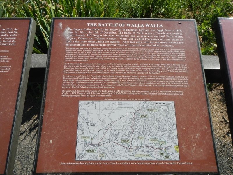
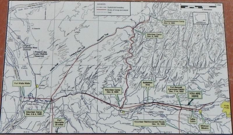
The conflict that took place here followed a running battle that started at the mouth of the Touchet River, nine miles west of here. The fighting took place in cold, snowy weather and encompassed the flat in front of you, the trees along the river, and these hills. A central point was the cabin of Joseph Larocque and his wife Lizette Walla Walla, located where the current farm buildings are just to the west. The out-numbered and ill-equipped volunteers took refuge and set ups their field headquarters and hospital there, which they enclosed in a stockade they called Fort Bennett. The main battlefield was located between the Larocque cabin and the cabin of Louis Tellier and Anqelique Pendoreille, a mile east of here. The Tellier cabin changed hands several times, sometimes being occupied by the Indians, sometimes by the Volunteers. Also known as the Battle of Frenchtown, it became a four-day stand-off.
The battle at Frenchtown was part of a larger war which broke out in September of 1855. The Walla Walla Treaty Council held in May and June of that year provided for reservations for tribes of the region, and ceded the majority of their tribal lands to the United States. Immediately after the Treaty Council and long before the treaties were ratified by Congress, miners, and squatters began occupying tribal lands. The tribes resisted and tried to protect their property and livestock. Members of the Walla Walla tribe had raided the Fort Walla Walla trading post at Wallula, and their chief Peopeomoxmox had reportedly vowed to kill Governor Isaac Stevens on his return from a council with the Blackfeet.
In response to a call from U.S. Army Major Gabriel Rains, Oregon Mounted Volunteers marched from the Willamette Valley and established Fort Henrietta on the Umatilla River. After inspecting the abandoned Fort Walla Walla trading post, they marched towards the Touchet River to punish the Walla Walla. Chief Peopeomoxmox met them under a white flag of truce and at their insistence became their hostage to prevent an immediate attack on his village. When the Volunteers returned to the Walla Walla River and started up the valley to establish a winter camp at the old Whitman Mission, the
battle began. Peopeomoxmox and four other hostages were killed by the Volunteers while in captivity at the Larocque cabin during the first day of the battle. The Chief's body was mutilated and dismembered.
The larger conflict known as the Yakama War finally ended in 1858 following an aggressive campaign by the U.S. Army under Colonel George Wright. In 1859, Congress ratified the three treaties signed in Walla Walla resulting in the Yakama, Nez Perce, and Umatilla reservations and officially opening the rest of the region to white settlement.
More information about the Battle and the Treaty Council is available at www.frenchtownpartners.org and at Tamástslikt Culture Institute.
Erected by Tamastslikt Cultural Institute.
Topics. This historical marker is listed in these topic lists: Native Americans • Wars, US Indian. A significant historical date for this entry is December 7, 1855.
Location. 46° 3.049′ N, 118° 30.513′ W. Marker is in Walla Walla, Washington, in Walla Walla County. Marker can be reached from Old Highway 12 near U.S. 12. The marker is located at the top of the hill in Frenchtown Historic District, near the St. Rose Cemetery. Touch for map. Marker is at or near this postal address: 8174 Old Highway 12, Walla Walla WA 99362, United States of America. Touch for directions.
Other nearby markers. At least 8 other markers are within walking distance of this marker. Local Tribes (here, next to this marker); Frenchtown
(here, next to this marker); Saint Rose Mission (here, next to this marker); Welcome to the Prince's Cabin (approx. 0.2 miles away); Hudson's Bay Company (approx. 0.2 miles away); The Prince (approx. 0.2 miles away); French-Canadian Cabin Design (approx. 0.2 miles away); St. Rose Mission (approx. 0.2 miles away). Touch for a list and map of all markers in Walla Walla.
Also see . . . The Battle of Walla Walla -- Legends of America. The Walla Walla tribe, who was resisting the not yet ratified treaty and the premature opening of their lands, had raided the Fort Walla Walla trading post at Wallula. (Submitted on October 27, 2020, by Barry Swackhamer of Brentwood, California.)
Credits. This page was last revised on October 27, 2020. It was originally submitted on October 27, 2020, by Barry Swackhamer of Brentwood, California. This page has been viewed 293 times since then and 42 times this year. Photos: 1, 2, 3. submitted on October 27, 2020, by Barry Swackhamer of Brentwood, California.


